

LAS SPECIFICATION VERSION 1.4 – R11 - asprs
LAS SPECIFICATION VERSION 1.4 – R11 - asprs
LAS SPECIFICATION VERSION 1.4 – R11 - asprs

You also want an ePaper? Increase the reach of your titles
YUMPU automatically turns print PDFs into web optimized ePapers that Google loves.
File Source ID: This field should be set to a value ranging from 1 to 65,535. If this file was<br />
derived from an original flight line, this is often the flight line number. A value of zero (0) is<br />
interpreted to mean that an ID has not been assigned. In this case, processing software is free to<br />
assign a number. Note that this scheme allows a LIDAR project to contain up to 65,535 unique<br />
sources. A source can be an original flight line or it can be result of merge and/or extract<br />
operations.<br />
Global Encoding: This is a bit field used to indicate certain global properties about the file. In<br />
<strong>LAS</strong> 1.2 (the version in which this field was introduced), only the low bit is defined (this is the bit,<br />
that if set, would have the unsigned integer yield a value of 1). This bit field is defined as:<br />
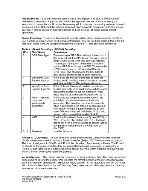
Table 4: Global Encoding - Bit Field Encoding<br />
Bits Field Name Description<br />
0 GPS Time Type The meaning of GPS Time in the point records. If<br />
this bit is not set, the GPS time in the point record<br />
fields is GPS Week Time (the same as versions<br />
1.0 through 1.2 of <strong>LAS</strong>). Otherwise, if this bit is<br />
set, the GPS Time is standard GPS Time (satellite<br />
GPS Time) minus 1 x 10 9 (Adjusted Standard<br />
GPS Time). The offset moves the time back to<br />
1 Waveform Data<br />
Packets Internal<br />
2 Waveform Data<br />
Packets External<br />
3 Return numbers<br />
have been<br />
synthetically<br />
generated<br />
near zero to improve floating point resolution.<br />
If this bit is set, the waveform data packets are<br />
located within this file (note that this bit is mutually<br />
exclusive with bit 2). This is deprecated now.<br />
If this bit is set, the waveform data packets are<br />
located externally in an auxiliary file with the same<br />
base name as this file but the extension *.wdp.<br />
(note that this bit is mutually exclusive with bit 1)<br />
If this bit is set, the point return numbers in the<br />
point data records have been synthetically<br />
generated. This could be the case, for example,<br />
when a composite file is created by combining a<br />
First Return File and a Last Return File. In this<br />
case, first return data will be labeled “1 of 2” and<br />
second return data will be labeled “2 of 2”<br />
4 WKT If set, the Coordinate Reference System (CRS) is<br />
WKT. If not set, the CRS is GeoTIFF. It should<br />
not be set if the file writer wishes to ensure legacy<br />
compatibility (which means the CRS must be<br />
GeoTIFF)<br />
5:15 Reserved Must be set to zero<br />
Project ID (GUID data): The four fields that comprise a complete Globally Unique Identifier<br />
(GUID) are now reserved for use as a Project Identifier (Project ID). The field remains optional.<br />
The time of assignment of the Project ID is at the discretion of processing software. The Project<br />
ID should be the same for all files that are associated with a unique project. By assigning a<br />
Project ID and using a File Source ID (defined above) every file within a project and every point<br />
within a file can be uniquely identified, globally.<br />
Version Number: The version number consists of a major and minor field. The major and minor<br />
fields combine to form the number that indicates the format number of the current specification<br />
itself. For example, specification number <strong>1.4</strong> would contain 1 in the major field and 4 in the minor<br />
field. It should be noted that the <strong>LAS</strong> Working Group does not associate any particular meaning<br />
to major or minor version number.<br />
American Society for Photogrammetry & Remote Sensing Page 6 of 27<br />
<strong>LAS</strong> <strong>SPECIFICATION</strong><br />
Version <strong>1.4</strong>-<strong>R11</strong>


