

LAS SPECIFICATION VERSION 1.4 – R11 - asprs
LAS SPECIFICATION VERSION 1.4 – R11 - asprs
LAS SPECIFICATION VERSION 1.4 – R11 - asprs

You also want an ePaper? Increase the reach of your titles
YUMPU automatically turns print PDFs into web optimized ePapers that Google loves.
A <strong>LAS</strong> <strong>1.4</strong> file writer who wishes to maintain backward compatibility must maintain both the<br />
legacy fields and the equivalent non-legacy fields in synchronization. Of course, this is not<br />
possible if the number of points exceeds UINT32_MAX, in which case the legacy fields must be<br />
set to zero. If a file writer is not maintaining backward compatibility, the legacy fields must always<br />
be set to zero.<br />
If there is a discrepancy between a non-zero legacy field and the equivalent <strong>LAS</strong> <strong>1.4</strong> field, the<br />
<strong>LAS</strong> <strong>1.4</strong> reader should use the legacy value to maintain the same behavior as a <strong>LAS</strong> 1.1 through<br />
<strong>LAS</strong> 1.3 reader. Best practice is to also throw an informative error so that the file can be<br />
repaired.<br />
COORDINATE REFERENCE SYSTEM (CRS) REPRESENTATION:<br />
GeoTIFF is being replaced by Well Known Text (WKT) as the required Coordinate Reference<br />
System (CRS) representation for the new point types (6-10) introduced by <strong>LAS</strong> <strong>1.4</strong>.<br />
GeoTIFF is maintained for legacy reasons for point types 0-5.<br />
A “WKT” bit has been added to the Global Encoding flag in the Public Header Block. If this bit is<br />
set, the CRS for the file will be located in the WKT (Extended) Variable Length Records (EVLR,<br />
VLR).<br />
A file writer who desires to maintain backward compatibility with legacy <strong>LAS</strong> for point types 0-5<br />
must add a GeoTIFF VLR to represent the CRS for the file and ensure that the WKT bit is false.<br />
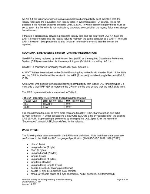
The CRS representation is summarized in Table 2<br />
Table 2: Coordinate Reference System Representation<br />
Point Type WKT bit == False WKT bit == True<br />
0-5 GeoTIFF WKT<br />
6-10 Error WKT<br />
It is considered a file error to have more than one GeoTIFF (E)VLR or more than one WKT<br />
(E)VLR in the file. A writer can append a new CRS EVLR to a file by “superseding” the existing<br />
CRS (E)VLR. Superseding is performed by changing the <strong>LAS</strong>_Spec ID of the record to<br />
“Superseded”, a new <strong>LAS</strong>F_Spec defined in this release.<br />
DATA TYPES:<br />
The following data types are used in the <strong>LAS</strong> format definition. Note that these data types are<br />
conformant to the 1999 ANSI C Language Specification (ANSI/ISO/IEC 9899:1999 ("C99").<br />
● char (1 byte)<br />
● unsigned char (1 byte)<br />
● short (2 bytes)<br />
● unsigned short (2 bytes)<br />
● long (4 bytes)<br />
● unsigned long (4 bytes)<br />
● long long (8 bytes)<br />
● unsigned long long (8 bytes)<br />
● float (4 byte IEEE floating point format)<br />
● double (8 byte IEEE floating point format)<br />
● string (a variable series of 1 byte characters, ASCII encoded, null terminated)<br />
American Society for Photogrammetry & Remote Sensing Page 4 of 27<br />
<strong>LAS</strong> <strong>SPECIFICATION</strong><br />
Version <strong>1.4</strong>-<strong>R11</strong>


