Nevada-Yuba-Placer Strategic Fire Plan 2011 - Board of Forestry ...
Nevada-Yuba-Placer Strategic Fire Plan 2011 - Board of Forestry ...
Nevada-Yuba-Placer Strategic Fire Plan 2011 - Board of Forestry ...
Create successful ePaper yourself
Turn your PDF publications into a flip-book with our unique Google optimized e-Paper software.
• Daugherty Hill Wildlife Area<br />
• Along Rural Roads in the Battalion<br />
• Oregon Ridge Fuel Break<br />
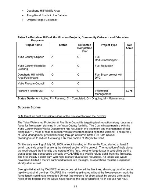
Table 7 – Battalion 16 Fuel Modification Projects, Community Outreach and Education<br />
Programs<br />
Project Name Status Estimated<br />
Completion<br />
Year<br />
95<br />
Project Type Net<br />
Acres<br />
<strong>Yuba</strong> County Chipper A O Fuel<br />
Reduction/Chipper<br />
<strong>Yuba</strong> County Roadside<br />
Clearing<br />
Daugherty Hill Wildlife<br />
Area Fuel breaks<br />
<strong>Yuba</strong> <strong>Fire</strong>safe Council O O<br />
A O Fuel Reduction<br />
O O Fuel Break project with<br />
DFG<br />
Richard’s Ranch VMP O O Vegetation<br />
Management<br />
Status Guide: A = Active, P = <strong>Plan</strong>ning, C = Completed, O = Ongoing, M = Maintenance.<br />
Success Stories<br />
BLM Grant for Fuel Reduction is One <strong>of</strong> the Keys to Stopping the Dry <strong>Fire</strong><br />
3,375<br />
The <strong>Yuba</strong> Watershed Protection & <strong>Fire</strong> Safe Council is targeting fuel reduction along roads as a<br />
focus for fire season planning in the <strong>Yuba</strong> County foothills. The Council’s partnership with the<br />
<strong>Yuba</strong> County Public Works Department has resulted in the treatment and maintenance <strong>of</strong> fuel<br />
along over 40 miles <strong>of</strong> road to reduce vehicle fires from spreading to the wildland. The Bureau<br />
<strong>of</strong> Land Management provided funding through California State <strong>Fire</strong> Safe Council<br />
Clearinghouse to reduce fuel along a six mile portion <strong>of</strong> Marysville Road.<br />
On the early evening <strong>of</strong> July 31, 2009, a truck traveling on Marysville Road started at least 5<br />
small road-side grass fires along the cleared section <strong>of</strong> the project. The reduction <strong>of</strong> fuels along<br />
the road slowed the intensity and spread <strong>of</strong> the fires. Another large factor in controlling the fire<br />
was a dozer line constructed annually by CALFIRE in a wildlife refuge uphill from the fire starts.<br />
The fires initially did not burn with high intensity due to fuel reductions. Air tanker use would<br />
have been limited if the fire continued to burn into the night, as operations must be suspended<br />
shortly after sunset.<br />
Strong initial attack by CALFIRE air resources reinforced the fire lines, allowing ground forces to<br />
rapidly control all the fires. CALFIRE fire modeling estimated without the fire prevention work the<br />
flame length could have exceeded 20 feet (too extreme for direct attack by ground units at the<br />
head <strong>of</strong> the fire)and the fire would have reached the top <strong>of</strong> Stanfield Hill in about a half hour.


