Pilot's Guide

You also want an ePaper? Increase the reach of your titles
YUMPU automatically turns print PDFs into web optimized ePapers that Google loves.
190-01194-00 Rev. A<br />
Garmin aera 795/796 Pilot’s <strong>Guide</strong><br />
GPS Navigation<br />
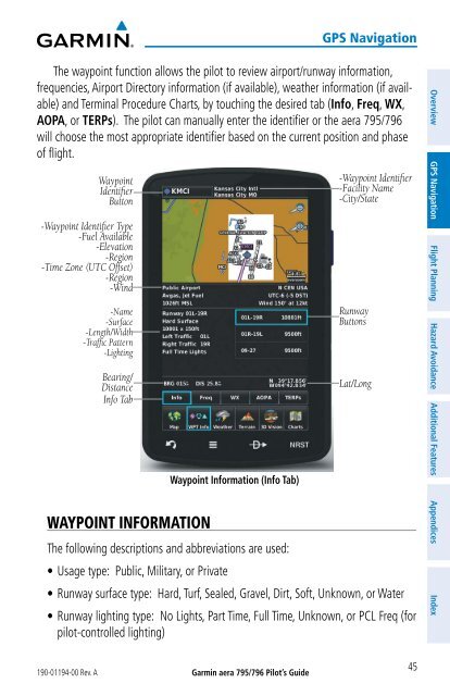
The waypoint function allows the pilot to review airport/runway information,<br />
frequencies, Airport Directory information (if available), weather information (if available)<br />
and Terminal Procedure Charts, by touching the desired tab (Info, Freq, WX,<br />
AOPA, or TERPs). The pilot can manually enter the identifier or the aera 795/796<br />
will choose the most appropriate identifier based on the current position and phase<br />
of flight.<br />
Waypoint<br />
Identifier<br />
Button<br />
-Waypoint Identifier Type<br />
-Fuel Available<br />
-Elevation<br />
-Region<br />
-Time Zone (UTC Offset)<br />
-Region<br />
-Wind<br />
-Name<br />
-Surface<br />
-Length/Width<br />
-Traffic Pattern<br />
-Lighting<br />
Bearing/<br />
Distance<br />
Info Tab<br />
WAYPOINT INFORMATION<br />
Waypoint Information (Info Tab)<br />
The following descriptions and abbreviations are used:<br />
• Usage type: Public, Military, or Private<br />
-Waypoint Identifier<br />
-Facility Name<br />
-City/State<br />
Runway<br />
Buttons<br />
Lat/Long<br />
• Runway surface type: Hard, Turf, Sealed, Gravel, Dirt, Soft, Unknown, or Water<br />
• Runway lighting type: No Lights, Part Time, Full Time, Unknown, or PCL Freq (for<br />
pilot-controlled lighting)<br />
45<br />
Overview GPS Navigation Flight Planning Hazard Avoidance Additional Features Appendices Index