Pilot's Guide

Create successful ePaper yourself
Turn your PDF publications into a flip-book with our unique Google optimized e-Paper software.
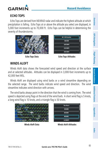
ECHO TOPS<br />
190-01194-00 Rev. A<br />
Garmin aera 795/796 Pilot’s <strong>Guide</strong><br />
Hazard Avoidance<br />
Echo Tops are derived from NEXRAD radar and indicate the highest altitude at which<br />
precipitation is falling. Echo Tops at or above the altitude you select are displayed, in<br />
5,000 foot increments up to 70,000 ft. Echo Tops can be helpful in determining the<br />
severity of thunderstorms.<br />
WINDS ALOFT<br />
Echo Tops Data Echo Tops Altitudes<br />
Winds Aloft data shows the forecasted wind speed and direction at the surface<br />
and at selected altitudes. Altitudes can be displayed in 3,000-foot increments up to<br />
42,000 feet MSL.<br />
Winds Aloft are displayed using wind barbs or a wind streamline depending on<br />
the selected range. The wind barbs indicate wind speed and direction. The wind<br />
streamline indicates wind direction with arrows.<br />
The wind barbs always point in the direction that the wind is coming from. The wind<br />
speed is depicted using flags at the end of the wind barb. A short wind flag is 5 knots,<br />
a long wind flag is 10 knots, and a triangle flag is 50 knots.<br />
Winds Aloft Data Winds Aloft Altitudes<br />
83<br />
Overview GPS Navigation Flight Planning Hazard Avoidance Additional Features Appendices Index