

Athgarvan Local Area Plan 2007 (pdf) - Kildare.ie
Athgarvan Local Area Plan 2007 (pdf) - Kildare.ie
Athgarvan Local Area Plan 2007 (pdf) - Kildare.ie

You also want an ePaper? Increase the reach of your titles
YUMPU automatically turns print PDFs into web optimized ePapers that Google loves.
4<br />
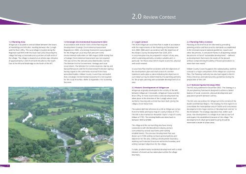
1.3 <strong>Plan</strong>ning <strong>Area</strong><br />
<strong>Athgarvan</strong> is situated in central <strong>Kildare</strong> between the towns<br />
of Newbridge and Kilcullen, nestling between the Curragh<br />
and the River Liffey. This rural village is located along the<br />
Regional road R416 with the local road L2032 bisecting the<br />
village forming a crossroads and a junction at both ends of<br />
the village. The village is situated at an almost equi-distance<br />
of approximately 3.5km from both Kilcullen to the South<br />
East of the M9 and Newbridge to the North of the M7.<br />
1.4 Strategic Environmental Assessment (SEA)<br />
In accordance with Article 13A(4) of the <strong>Plan</strong>ning and<br />
Development (Strategic Environmental Assessment<br />
Regulations) 2004, a Screening Assessment was prepared<br />
for the <strong>Athgarvan</strong> <strong>Local</strong> <strong>Area</strong> <strong>Plan</strong> and sent to the<br />
Environmental Authorit<strong>ie</strong>s on 18th August 2006 stating that<br />
a Strategic Environmental Assessment was not required.<br />
This was sent to the relevant prescribed bod<strong>ie</strong>s, namely<br />
The Minister for the Environment, Heritage and <strong>Local</strong><br />
Government, The Minister for Communications, Marine and<br />
Natural Resources and the Environmental Protection Agency.<br />
Having regard to the comments received from these<br />
prescribed bod<strong>ie</strong>s, <strong>Kildare</strong> County Council has concluded<br />
that a Strategic Environmental Assessment is not required<br />
for this <strong>Local</strong> <strong>Area</strong> <strong>Plan</strong>. (Refer to Appendix 3 for Screening<br />
Decision)<br />
2.0 Rev<strong>ie</strong>w Context<br />
2.1 Legal Context<br />
This Draft <strong>Athgarvan</strong> <strong>Local</strong> <strong>Area</strong> <strong>Plan</strong> is made in accordance<br />
with the requirements of the <strong>Plan</strong>ning and Development<br />
Acts 2000-2006 and in accordance with the objectives of<br />
the <strong>Kildare</strong> County Development <strong>Plan</strong> 2005-2011.<br />
A <strong>Local</strong> <strong>Area</strong> plan may be prepared in respect of any area,<br />
which a planning authority considers suitable and, in<br />
particular, for those areas which require economic, physical<br />
and social renewal.<br />
A <strong>Local</strong> <strong>Area</strong> <strong>Plan</strong> shall be consistent with the objectives of<br />
the development plan and shall consist of a written<br />
statement and a plan or plans indicating the objectives in<br />
such detail as may be determined by the planning authority<br />
for the proper planning and sustainable development of an<br />
area.<br />
2.2 Historic Development of <strong>Athgarvan</strong><br />
<strong>Athgarvan</strong> originally developed in the vicinity of the Mill,<br />
between <strong>Athgarvan</strong> Crossroads, <strong>Athgarvan</strong> House and the<br />
River Liffey. In more recent times some development has<br />
taken place in the direction of the Curragh where <strong>Local</strong><br />
Authority housing and a school has been built, giving the<br />
village a more linear form.<br />
The earl<strong>ie</strong>st definite reference to a mill at <strong>Athgarvan</strong> comes<br />
from the Noble and Keane map of County <strong>Kildare</strong> of 1752.<br />
The mill is also marked on Alexander Taylor’s map of County<br />
<strong>Kildare</strong> of 1783. The existing Malthouse dates back to<br />
between 1840 and1880.<br />
The village and the surrounding area have strong<br />
connections with the bloodstock industry and are<br />
surrounded by several stud farms and training<br />
establishments. The previous Development <strong>Plan</strong> was<br />
drawn up in 1996 setting out basic general polic<strong>ie</strong>s and<br />
objectives for the area, setting a development boundary,<br />
marking out Protected Structures within the boundary and<br />
setting transport objectives for the village.<br />
To date, predominately residential development with a small<br />
element of mixed use has taken place within the village<br />
boundary.<br />
2.3 <strong>Plan</strong>ning Policy Context<br />
<strong>Plan</strong>ning at this level must be informed by prevailing<br />
planning polic<strong>ie</strong>s and best practice standards as established<br />
in the international and national guidelines, reports and<br />
other documents. A consistent theme in all planning related<br />
documents is that of “sustainable development” – defined<br />
as development that meets the needs of the present<br />
without compromising the ability of future generations to<br />
meet their own needs.”<br />
<strong>Kildare</strong> County Council supports this national policy and this<br />
concept is a major component of the <strong>Athgarvan</strong> <strong>Local</strong> <strong>Area</strong><br />
<strong>Plan</strong>. The <strong>Plan</strong>ning Authority has also had regard to the EU<br />
Policy Directives and national policy guidelines during the<br />
preparation of this LAP.<br />
2.3.1 National Spatial Strategy (NSS)<br />
The NSS was published in December 2002. The Strategy is a<br />
20 year planning framework designed to ach<strong>ie</strong>ve a better<br />
balance of social, economic, physical development and<br />
population growth between centres.<br />
The NSS sets out polic<strong>ie</strong>s for <strong>Athgarvan</strong> in the context of the<br />
Dublin and Mid-East Region. The strategy for this region is to<br />
consolidate the metropolitan area of Dublin and concentrate<br />
development into major centres or “development centres” in<br />
the hinterland. The strategy stipulates that, within such<br />
areas, new development in a village must take account of<br />
and respect the established character of the village. The<br />
development of urban generated housing should be<br />
minimised outside of urban areas.<br />
5


