

Athgarvan Local Area Plan 2007 (pdf) - Kildare.ie
Athgarvan Local Area Plan 2007 (pdf) - Kildare.ie
Athgarvan Local Area Plan 2007 (pdf) - Kildare.ie

You also want an ePaper? Increase the reach of your titles
YUMPU automatically turns print PDFs into web optimized ePapers that Google loves.
8<br />
Specific goals of this plan, as translated into sectoral<br />
objectives and polic<strong>ie</strong>s in Chapter 3 are:<br />
• To rationalise the pattern of development in the village<br />
and to promote the development of a more coherent<br />
village core.<br />
• To identify appropriate areas for community and<br />
amenity focussed mixed-use development.<br />
• To identify additional areas for new and infill residential<br />
development, along with areas for local employment /<br />
enterprise, community and amenity.<br />
• To provide an orderly and definite edge between the<br />
village and its rural surroundings.<br />
• To maintain a strong visual and physical separation<br />
between <strong>Athgarvan</strong> and its neighbouring towns of<br />
Newbridge and Kilcullen.<br />
• To improve physical and social infrastructure services<br />
throughout the village.<br />
This LAP aims to address issues relating to the management<br />
of change in the village of <strong>Athgarvan</strong> and in particular the<br />
enhancement of the built and natural environment.<br />
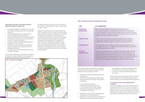
Figure 1 Strategic Considerations<br />
The Strategy is based on a number of key characteristics of<br />
the local area, as indicated below on Figure 1 and described<br />
on Table 1 overleaf.<br />
<strong>Athgarvan</strong> is nestled within areas of higher ground to the<br />
north, west and east. There is currently a trend of increased<br />
growth towards the direction of Newbridge. It is considered<br />
that the aforementioned areas cannot assimilate new<br />
development without significant impacts on the landscape<br />
and the overall character and integrity of the settlement,<br />
having regard to the topography of the village and its<br />
proximity to the NHA designated Curragh and the River<br />
Liffey. These factors, along with the principles of proper<br />
planning and sustainable development have combined to<br />
influence the overall longer term development strategy of<br />
the village, being directed towards the south of the existing<br />
settlement pattern.<br />
Table 1 Explanatory Notes of Development Strategy<br />
AREA KEY CONSIDERATION<br />
The Curragh This is a vast area of significant importance internationally and locally.<br />
Amenity Zone The Curragh is designated as a Natural Heritage <strong>Area</strong> (NHA) and is also identif<strong>ie</strong>d<br />
as a Special Landscape <strong>Area</strong> in the County Development <strong>Plan</strong>. It should be maintained<br />
free from unsuitable, incompatible development in order to protect its environmental,<br />
heritage, commercial and recreational integrity.<br />
The River Liffey The River Liffey is an important recreational and wildlife amenity in <strong>Athgarvan</strong>.<br />
It is proposed to maintain and improve the amenity of the Liffey through the<br />
protection of the River and its banks by zoning it for amenity recreation use.<br />
The Village Core The existing village core is at <strong>Athgarvan</strong> Crossroads providing limited local services<br />
(shop, public house, florist). The village centre should be consolidated and expanded<br />
to provide a wider range of local services.<br />
Favoured The IFPLUT covering the <strong>Athgarvan</strong> area identif<strong>ie</strong>s and considers lands to the south<br />
Expansion Zone of the existing settlement to be most suited to new and infill development, in the<br />
longer term and over the period of more than one LAP, in order to strengthen and<br />
consolidate the village development pattern and to provide for additional development<br />
lands. Development along the southern side of the village during the lifetime of<br />
this plan should not jeopardise the villages future ability to expand to the south.<br />
Having regard to these considerations, a development<br />
strategy with well defined edges and land use zones is<br />
defined, with the key objectives as follows:<br />
• Enhancement, strengthening and development of<br />
the village core.<br />
• Intensification and rationalisation of the existing<br />
residential footprint of the village, having regard to<br />
the following:<br />
1. The improvement of the road<br />
network and traffic management system.<br />
2. The introduction of the Curragh Sewerage<br />
Scheme and the phasing out of septic tanks<br />
3. Development of in fill sites;<br />
• Identification of lands suited to the establishment<br />
and expansion of community facilit<strong>ie</strong>s.<br />
• Definition of the lands north and south of the L2032<br />
with all adjacent sites fronting onto the roadway,<br />
thus providing a more aesthetically pleasing village.<br />
• Clear definition of all boundar<strong>ie</strong>s of <strong>Athgarvan</strong>.<br />
• Creation of an open space/amenity area along the<br />
River Liffey.<br />
<strong>Kildare</strong> County Council will implement this <strong>Plan</strong>, and secure<br />
the stated objectives, through its planning polic<strong>ie</strong>s and<br />
decision-making in terms of individual planning applications.<br />
2.7 Monitoring, rev<strong>ie</strong>w and implementation<br />
of the <strong>Plan</strong><br />
The Council is obliged to monitor and rev<strong>ie</strong>w the operation<br />
and implementation of the <strong>Plan</strong>. The Council will seek to<br />
implement the aims, polic<strong>ie</strong>s and objectives of the <strong>Plan</strong> in a<br />
proactive manner. The Council will engage with all relevant<br />
stakeholders, both statutory and non-statutory agenc<strong>ie</strong>s and<br />
organisations through the development control process.<br />
9


