

San Bernardino National Forest Land Management Plan - Part 2
San Bernardino National Forest Land Management Plan - Part 2
San Bernardino National Forest Land Management Plan - Part 2

Create successful ePaper yourself
Turn your PDF publications into a flip-book with our unique Google optimized e-Paper software.
September 2005 <strong>Land</strong> <strong>Management</strong> <strong>Plan</strong> <strong>Part</strong> 2<br />
<strong>San</strong> <strong>Bernardino</strong> <strong>National</strong> <strong>Forest</strong> Strategy<br />
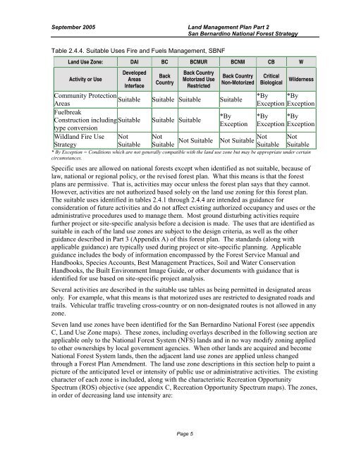
Table 2.4.4. Suitable Uses Fire and Fuels <strong>Management</strong>, SBNF<br />
<strong>Land</strong> Use Zone: DAI BC BCMUR BCNM CB W<br />
Activity or Use<br />
Developed<br />
Areas<br />
Interface<br />
Back<br />
Country<br />
Back Country<br />
Motorized Use<br />
Restricted<br />
Back Country<br />
Non-Motorized<br />
Critical<br />
Biological Wilderness<br />
Community Protection<br />
Suitable<br />
Areas<br />
Suitable Suitable Suitable<br />
*By *By<br />
Exception Exception<br />
Fuelbreak<br />
Construction including<br />
Suitable<br />
type conversion<br />
Suitable Suitable<br />
*By<br />
Exception<br />
*By *By<br />
Exception Exception<br />
Wildland Fire Use<br />
Strategy<br />
Not<br />
Suitable Not<br />
Not<br />
Not Suitable Not Suitable Suit able Suitable Not<br />
Suitable<br />
* By Exception = Conditions which are not generally compatible with the land use zone but may be appropriate under certain<br />
circumstances.<br />
Specific uses<br />
are allowed on national forests except when identified as not suitable, because of<br />
law, national or regional policy, or the revised forest plan. What this means is that the forest<br />
plans are permissive. That is, activities may occur unless the forest plan says that they cannot.<br />
However, activities are not authorized based solely on the land use zoning for this forest plan.<br />
The suitable uses identified in tables 2.4.1 through 2.4.4 are intended as guidance for<br />
consideration of future activities and do not affect existing authorized occupancy and uses<br />
or the<br />
administrative procedures used to manage them. Most ground disturbing activities require<br />
further project or site-specific analysis before a decision is made. The uses that are identified<br />
as<br />
suitable in each of the land use zones are subject to the design criteria, as well as the other<br />
guidance described in <strong>Part</strong> 3 (Appendix A) of this forest plan. The standards (along with<br />
applicable guidance) are typically used during project or site-specific planning. Applicable<br />
guidance includes the body of information encompassed by the <strong>Forest</strong> Service Manual and<br />
Handbooks, Species Accounts, Best <strong>Management</strong> Practices, Soil and Water Conservation<br />
Handbooks, the Built Environment Image Guide, or other documents with guidance that is<br />
identified for use based on site-specific project analysis.<br />
Several activities are described in the suitable use tables as<br />
being permitted in designated areas<br />
only. For example, what this means is that motorized uses are restricted to designated roads and<br />
trails. Vehicular traffic traveling cross-country or on non-designated routes is not allowed in any<br />
zone.<br />
Seven land use zones have been identified for the <strong>San</strong> <strong>Bernardino</strong> <strong>National</strong> <strong>Forest</strong> (see appendix<br />
C, <strong>Land</strong> Use Zone maps). These zones, including overlays described in the following section are<br />
applicable only to the <strong>National</strong> <strong>Forest</strong> System (NFS) lands and in no way modify zoning applied<br />
to other ownerships by local government agencies. When other lands are acquired and become<br />
<strong>National</strong> <strong>Forest</strong> System lands, then the adjacent land use zones are applied unless changed<br />
through a <strong>Forest</strong> <strong>Plan</strong> Amendment. The land use zone descriptions in this section help to paint<br />
a<br />
picture of the anticipated level or intensity of public use or administrative activities. The existing<br />
character of each zone is included, along with the characteristic Recreation Opportunity<br />
Spectrum (ROS) objective (see appendix C, Recreation Opportunity Spectrum maps). The<br />
zones,<br />
in order of decreasing land use intensity are:<br />
Page 5


