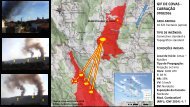
Relatório do Acidente ocorrido no Incêndio Florestal de Yarnel Hill
Neste incêndio, de 30 de Junho de 2013, morreram 19 combatentes florestais da equipa "Hot Shot" de Granite Mountain.
Neste incêndio, de 30 de Junho de 2013, morreram 19 combatentes florestais da equipa "Hot Shot" de Granite Mountain.

You also want an ePaper? Increase the reach of your titles
YUMPU automatically turns print PDFs into web optimized ePapers that Google loves.
• Fire behavior observed by the Granite Mountain IHC all day was in pulses and variable,<br />
<strong>no</strong>t a consistent fire spread direction.<br />
• The Granite Mountain IHC’s original assignment to establish an anchor point and<br />
construct fireline was <strong>no</strong> longer valid based on the fire’s movement.<br />
• The Granite Mountain IHC knew they were the only resource left on the fireline. The<br />
Blue Ridge IHC was pulling back to <strong>Yarnel</strong>l.<br />
• The primary focus of operational activity on the fire that day was on structure protection<br />
to the <strong>no</strong>rth and <strong>no</strong>rtheast. However, by this time, the fire was moving southeast and<br />
was beginning to threaten <strong>Yarnel</strong>l. A Granite Mountain IHC member sent a text message<br />
at 1555: “Fire is running at <strong>Yarnel</strong>l!”<br />
• General radio traffic markedly increased with the fire heading into <strong>Yarnel</strong>l, the<br />
evacuation or<strong>de</strong>r and its immediate initiation.<br />
• A Granite Mountain IHC member sent a photo text message at 1604: “This thing is<br />
runnin straight for yarnel jus starting evac. You can see fire on left town on the right.”<br />
• The Granite Mountain IHC heard the Boul<strong>de</strong>r Springs Ranch was a “bomb proof safety<br />
zone” that morning. Using Google Maps and an iPad, they had seen the Ranch, as well<br />
as potential trails and roads leading to it.<br />
COURSES OF ACTION AVAILABLE AT POINT A, AT ABOUT 1604:<br />
Course of Action A1: Stay in the black<br />
• An active weather update called for <strong>no</strong>rth-<strong>no</strong>rtheast winds with gusts up to 50 mph. Fire<br />
spread direction was likely to change during the after<strong>no</strong>on. The fire was actively running<br />
to the east-southeast, exhibiting extreme fire behavior, which exposes a very long flank.<br />
If the <strong>no</strong>rth wind materialized, it could drive the open flank south (i.e., the flank could<br />
turn into a head fire).<br />
• The cold, black area adjacent to them was over 400 acres and exten<strong>de</strong>d over the lee<br />
si<strong>de</strong> of the ridge.<br />
• The Granite Mountain IHC was on foot, separated from their trucks with limited overall<br />
mobility.<br />
• The Granite Mountain IHC and DIVS A were the only resources remaining on the fireline;<br />
the others had withdrawn to <strong>Yarnel</strong>l.<br />
• The Granite Mountain IHC’s original assignment to establish an anchor point and<br />
construct fireline was <strong>no</strong> longer valid based on fire movement, so there was <strong>no</strong> tactical<br />
reason to remain at this location.<br />
<strong>Yarnel</strong>l <strong>Hill</strong> Fire Serious Acci<strong>de</strong>nt Investigation 35