Relatório do Acidente ocorrido no Incêndio Florestal de Yarnel Hill
Neste incêndio, de 30 de Junho de 2013, morreram 19 combatentes florestais da equipa "Hot Shot" de Granite Mountain.
Neste incêndio, de 30 de Junho de 2013, morreram 19 combatentes florestais da equipa "Hot Shot" de Granite Mountain.

You also want an ePaper? Increase the reach of your titles
YUMPU automatically turns print PDFs into web optimized ePapers that Google loves.
help <strong>de</strong>tect trends in fire behavior<br />
based on smoke plume<br />
<strong>de</strong>velopment. The Flagstaff Doppler<br />
radar showed an increase in plume<br />
height shortly after the outflow<br />
boundary initially passed, likely<br />
indicative of increased fire behavior.<br />
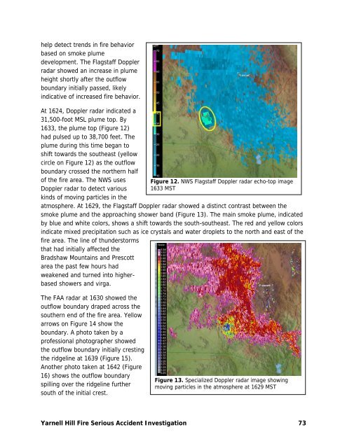
At 1624, Doppler radar indicated a<br />
31,500-foot MSL plume top. By<br />
1633, the plume top (Figure 12)<br />
had pulsed up to 38,700 feet. The<br />
plume during this time began to<br />
shift towards the southeast (yellow<br />
circle on Figure 12) as the outflow<br />
boundary crossed the <strong>no</strong>rthern half<br />
of the fire area. The NWS uses<br />
Doppler radar to <strong>de</strong>tect various<br />
kinds of moving particles in the<br />
atmosphere. At 1629, the Flagstaff Doppler radar showed a distinct contrast between the<br />
smoke plume and the approaching shower band (Figure 13). The main smoke plume, indicated<br />
by blue and white colors, shows a shift towards the south-southeast. The red and yellow colors<br />
indicate mixed precipitation such as ice crystals and water droplets to the <strong>no</strong>rth and east of the<br />
fire area. The line of thun<strong>de</strong>rstorms<br />
that had initially affected the<br />
Bradshaw Mountains and Prescott<br />
area the past few hours had<br />
weakened and turned into higherbased<br />
showers and virga.<br />
The FAA radar at 1630 showed the<br />
outflow boundary draped across the<br />
southern end of the fire area. Yellow<br />
arrows on Figure 14 show the<br />
boundary. A photo taken by a<br />
professional photographer showed<br />
the outflow boundary initially cresting<br />
the ridgeline at 1639 (Figure 15).<br />
A<strong>no</strong>ther photo taken at 1642 (Figure<br />
16) shows the outflow boundary<br />
spilling over the ridgeline further<br />
south of the initial crest.<br />
Figure 12. NWS Flagstaff Doppler radar echo-top image<br />
1633 MST<br />
Figure 13. Specialized Doppler radar image showing<br />
moving particles in the atmosphere at 1629 MST<br />
<strong>Yarnel</strong>l <strong>Hill</strong> Fire Serious Acci<strong>de</strong>nt Investigation 73