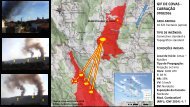
Relatório do Acidente ocorrido no Incêndio Florestal de Yarnel Hill
Neste incêndio, de 30 de Junho de 2013, morreram 19 combatentes florestais da equipa "Hot Shot" de Granite Mountain.
Neste incêndio, de 30 de Junho de 2013, morreram 19 combatentes florestais da equipa "Hot Shot" de Granite Mountain.

You also want an ePaper? Increase the reach of your titles
YUMPU automatically turns print PDFs into web optimized ePapers that Google loves.
Weather: The Southwest region of the United States experiences a weather phe<strong>no</strong>me<strong>no</strong>n<br />
k<strong>no</strong>wn as the Summer Monsoon. The monsoon period represents a switch in wind patterns<br />
from a drier westerly flow to a moist southerly or easterly flow. This typically occurs from mid-<br />
June through mid-July and generally lasts into September. During the initial stages of the<br />
monsoon, drier thun<strong>de</strong>rstorms are <strong>do</strong>minant but generally give way to larger footprints of<br />
wetter storms. Gusty outflow winds <strong>do</strong>minate the drier thun<strong>de</strong>rstorm period. Storms typically<br />
form over the higher terrain such as the Mogollon Rim and then try to move off the higher<br />
terrain as the day progresses. Terrain features pertinent to thun<strong>de</strong>rstorm formation inclu<strong>de</strong> the<br />
Bradshaw Mountains and Mogollon Rim. There is typically a one to two-week period when the<br />
moisture shift is dynamic and provi<strong>de</strong>s highly variable weather.<br />
Temperatures are typically hot just prior to and during this transition. Relative humidity values<br />
will start out low and then fluctuate wi<strong>de</strong>ly as storms and cloud cover become more numerous.<br />
Winds are highly variable during this period with highest wind speeds tied to thun<strong>de</strong>rstorms.<br />
These winds, k<strong>no</strong>wn as <strong>do</strong>wndrafts, micro-bursts, outflows, and gust fronts, generally <strong>de</strong>liver<br />
erratic wind shifts and short bursts of strong speeds.<br />
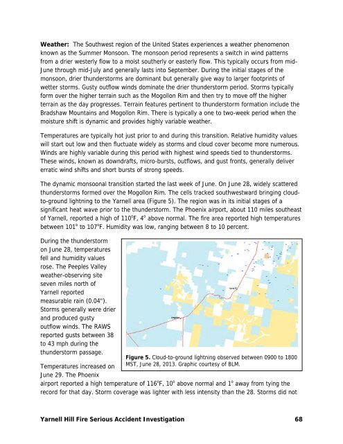
The dynamic monsoonal transition started the last week of June. On June 28, wi<strong>de</strong>ly scattered<br />
thun<strong>de</strong>rstorms formed over the Mogollon Rim. The cells tracked southwestward bringing cloudto-ground<br />
lightning to the <strong>Yarnel</strong>l area (Figure 5). The region was in its initial stages of a<br />
significant heat wave prior to the thun<strong>de</strong>rstorm. The Phoenix airport, about 110 miles southeast<br />
of <strong>Yarnel</strong>l, reported a high of 110 o F, 4 o above <strong>no</strong>rmal. The fire area reported high temperatures<br />
between 101 o to 107 o F. Humidity was low, ranging between 8 to 10 percent.<br />
During the thun<strong>de</strong>rstorm<br />
on June 28, temperatures<br />
fell and humidity values<br />
rose. The Peeples Valley<br />
weather-observing site<br />
seven miles <strong>no</strong>rth of<br />
<strong>Yarnel</strong>l reported<br />
measurable rain (0.04").<br />
Storms generally were drier<br />
and produced gusty<br />
outflow winds. The RAWS<br />
reported gusts between 38<br />
to 43 mph during the<br />
thun<strong>de</strong>rstorm passage.<br />
Figure 5. Cloud-to-ground lightning observed between 0900 to 1800<br />
MST, June 28, 2013. Graphic courtesy of BLM.<br />
Temperatures increased on<br />
June 29. The Phoenix<br />
airport reported a high temperature of 116 o F, 10 o above <strong>no</strong>rmal and 1 o away from tying the<br />
record for that day. Storm coverage was lighter with less intensity than the 28. Storms did <strong>no</strong>t<br />
<strong>Yarnel</strong>l <strong>Hill</strong> Fire Serious Acci<strong>de</strong>nt Investigation 68