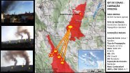
Relatório do Acidente ocorrido no Incêndio Florestal de Yarnel Hill
Neste incêndio, de 30 de Junho de 2013, morreram 19 combatentes florestais da equipa "Hot Shot" de Granite Mountain.
Neste incêndio, de 30 de Junho de 2013, morreram 19 combatentes florestais da equipa "Hot Shot" de Granite Mountain.

You also want an ePaper? Increase the reach of your titles
YUMPU automatically turns print PDFs into web optimized ePapers that Google loves.
• If they <strong>de</strong>scen<strong>de</strong>d from the ridge, they would maintain sight of the Ranch.<br />
• Fire was still heading east-southeast toward <strong>Yarnel</strong>l.<br />
• Smoke column was pre<strong>do</strong>minantly going east-southeast with clear air south of the fire.<br />
As the crew reached the <strong>de</strong>scent point at about 1620, they likely knew or perceived:<br />
• Below the two-track road, they could see the following:<br />
o A box canyon<br />
o Pockets of heavy brush mixed with rock-strewn hillsi<strong>de</strong>s with some large boul<strong>de</strong>rs<br />
o Washes and game trails and areas of lesser vegetation they could tie together and<br />
make a path<br />
o Steep <strong>de</strong>scent initially and then flattening terrain<br />
• The direct path to the Ranch appeared shorter, and potentially faster, than continuing to<br />
follow the two-track road around the rim of the box canyon.<br />
• The weather in the update had <strong>no</strong>t materialized at their location and the update was<br />
about 50 minutes old.<br />
WHAT THEY LIKELY DID NOT KNOW AT POINT B:<br />
• A large thun<strong>de</strong>rstorm over 15 miles to the <strong>no</strong>rth and <strong>no</strong>rtheast was creating an outflow<br />
boundary that was going to cause a wind direction shift and increase in velocity,<br />
resulting in an increase in fire spread rates and a directional change to the south.<br />
• This outflow boundary had reached the <strong>no</strong>rth end of the fire at 1618 according to<br />
Fe<strong>de</strong>ral Aviation Administration (FAA) radar.<br />
• The crew’s possible rate of travel would be less than half of what it had been to this<br />
point due to lack of a <strong>de</strong>fined trail, heavy vegetation, and rocky terrain between the<br />
crew and the Ranch.<br />
• Boul<strong>de</strong>r Springs Ranch was further away than it appeared.<br />
• Other resources did <strong>no</strong>t un<strong>de</strong>rstand fully when the Granite Mountain IHC attempted to<br />
communicate their movement.<br />
FOUR COURSES OF ACTION AVAILABLE AT POINT B, AROUND 1620:<br />
Course of Action B1: Descend here; move toward the Ranch through the box canyon<br />
• Appeared to be the most direct, shortest, and fastest path to the Ranch.<br />
• The fastest route was <strong>de</strong>sirable because of the perceived threat to the community of<br />
<strong>Yarnel</strong>l.<br />
<strong>Yarnel</strong>l <strong>Hill</strong> Fire Serious Acci<strong>de</strong>nt Investigation 38