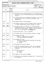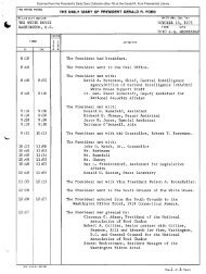
October 31, 1975 - Gerald R. Ford Presidential Library and Museum
October 31, 1975 - Gerald R. Ford Presidential Library and Museum
October 31, 1975 - Gerald R. Ford Presidential Library and Museum

Create successful ePaper yourself
Turn your PDF publications into a flip-book with our unique Google optimized e-Paper software.
The Eugene Isl<strong>and</strong> Block 32 oil <strong>and</strong> gas field is located 15 miles offshore<br />
from St. Mary Parish of southern Louisiana in 16-20 feet of water. The<br />
location is 95 miles west southwest of New Orleans in the offshore<br />
Miocene belt.<br />
The producing formations consist of 21 separate s<strong>and</strong>s in a thick Miocene<br />
s<strong>and</strong>-shale sequence at depths from 6,400 to 12,800 feet.<br />
The structure at Eugene Isl<strong>and</strong> Block 32 field is a slightly elongated dome<br />
with an east wes.t axis. The dome was caused by deep seated salt intrusion.<br />
The Jurassic Louann salt has been encountered at about 17,000 feet. There<br />
are several northeast southwest faults that cross the field which, together<br />
with partial withdrawal of the salt, have caused a series of graben blocks<br />
over the center of the dome. The s<strong>and</strong>s are overlain <strong>and</strong> underlain by shale,<br />
<strong>and</strong> bottom water is present in most reservoirs. A tendency for some of the<br />
s<strong>and</strong> members to shale-out provides additional reservoir delineation. There<br />
are 17 productive <strong>and</strong> 4 depleted oil reservoirs occurring from 6,400 to 10,400<br />
feet. There are six productive <strong>and</strong> three depleted nonassociated gas reservoirs<br />
from 10,100 to 12,800 feet. The productive area of the field is 2,000 acres<br />
(3 square miles).<br />
Hydrocarbons originally in place were estimated by the volumetric analysis method.<br />
The report is very well documented with structure <strong>and</strong> isopach maps as well<br />
as with reservoir rock <strong>and</strong> fluid parameters for the important zones. The<br />
study team, in some instances, could not determine the exact position of<br />
the gas/oil contact in reservoir segments containing original gas caps.<br />
The oil reservoirs produce with combinations of water drive <strong>and</strong> gas cap drive.<br />
A water injection project is active in one reservoir <strong>and</strong> secondary recovery<br />
reserves are indicated for five reservoirs. The nonassociated gas reservoirs<br />
produce with combinations of pressure depletion <strong>and</strong> water drive.<br />
Ultimate recovery <strong>and</strong> proved reserves at Eugene Isl<strong>and</strong> Block 32 field have<br />
been estimated by determination of recovery efficiency factors based on<br />
empirical methods, with adjustments based upon judgment of the study team.<br />
The report mentions that there is a higher probability of the estimates<br />
being optimistic than pessimistic. Furthermore, the report mentions that<br />
the production of the proved reserves will require workovers, recompletions,<br />
drill"ing of new wells, <strong>and</strong> secondary recovery projects--the economics of<br />
which have not been considered. Again, the report states that recoveries<br />
from some of the smaller reservoirs may be overly optimistic. The recovery<br />
from the nonassociated gas reservoirs, producing with pressure depletion,<br />
was determined from study of pressure data versus cumulative production<br />
relationships.<br />
The FEA report on the Eugene Isl<strong>and</strong> Block 32 field has been prepared by<br />
the U.S. Geological Survey, Department of the Interior, under Interagency<br />
Agreement CG-05-50059-00.<br />
56