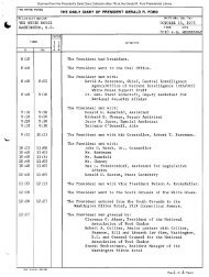
October 31, 1975 - Gerald R. Ford Presidential Library and Museum
October 31, 1975 - Gerald R. Ford Presidential Library and Museum
October 31, 1975 - Gerald R. Ford Presidential Library and Museum

Create successful ePaper yourself
Turn your PDF publications into a flip-book with our unique Google optimized e-Paper software.
The Spraberry Trend oil field is located in Upton, Reagan, Irion,<br />
Martin, Midl<strong>and</strong>, <strong>and</strong> Glasscock Counties of West Texas, within the<br />
Midl<strong>and</strong> Basin.<br />
The producing formations are the Upper <strong>and</strong> Lower Spraberry which are<br />
C1earfork-Wichita equivalent of Permian age. The underlying Dean S<strong>and</strong><br />
is Wo1fcamp, also of Permian age. The Upper Spraberry is generally<br />
around 400 feet thick; the Lower Spraberry ranges from 500 to 600 feet<br />
in thickness; <strong>and</strong> the Dean S<strong>and</strong> is about 120 feet thick. Over most of<br />
the area. about 90 percent of the thickness is s<strong>and</strong>, s·i1t. <strong>and</strong> shale<br />
(mostly shale). The remaining 10 percent or so is limestone <strong>and</strong><br />
dolomite. The oil is indigenous to the formation. The reservoir rock<br />
is extremely low in porosity <strong>and</strong> permeability, <strong>and</strong> is a siltstone.<br />
Production is made possible by fractures which extend through both<br />
the matrix siltstone <strong>and</strong> the shale. Depth to the top of the Upper<br />
Spraberry varies from 6,000 to 8,000 feet.<br />
The oil accumulations in the Spraberry are trapped stratigraphically.<br />
The area is virtually devoid of folded or faulted traps. The structure<br />
is a general monocline dipping from the eastern shelf into the depths<br />
of the Midl<strong>and</strong> Basin. The classic sections grade into limestones <strong>and</strong><br />
dolomites on the rims of the basin. The productive field, as defined<br />
by the Texas Railroad Commission, covers 920,000 acres (about 1,400<br />
square miles). The consultant firm also estimates that an additional<br />
150,000 acres on the fringes of the field may be developed in the<br />
future.<br />
The crude oil at Spraberry Trend was initially undersaturated. However,<br />
because of low permeability, pressure was quickly reduced in the<br />
vicinity of producing wells causing release of gas from solution <strong>and</strong><br />
high producing gas/oil ratios. The primary producing mechanism was a<br />
dissolved gas drive. Bottom water is not active. Oil drains from the<br />
siltstone matrix into the fracture system <strong>and</strong> productivity depends on<br />
the effectivel1ess of this fracture system. The normal spacing is 160<br />
acres per well <strong>and</strong> over 3,900 wells are currently producing. About .<br />
320,000 acres or 35 percent of the presently defined area of the field<br />
have been under water flood.<br />
Ultimate recovery by primary methods was determined by preparing<br />
production decline curves for each lease. Primary ultimate recovery<br />
is expected to average 500 barrels per acre. Secondary ultimate<br />
recovery was similarly estimated by studying the production records<br />
for the 34 water flood units. The contractor estimated that additional<br />
secondary recovery will average 200 barrels per acre. These volumes<br />
are considered proved. The secondary recovery reserves for 375,000<br />
acres of future projects are reported under "Indicated Secondary<br />
Reserves." The availability of production decline information <strong>and</strong><br />
the 80 percent extent of depletion of the proved volumes should cause<br />
the reserves estimate to be quite firm.<br />
152