Technologies for intensification in SW Uganda ... - Foodnet - cgiar
Technologies for intensification in SW Uganda ... - Foodnet - cgiar
Technologies for intensification in SW Uganda ... - Foodnet - cgiar

Create successful ePaper yourself
Turn your PDF publications into a flip-book with our unique Google optimized e-Paper software.
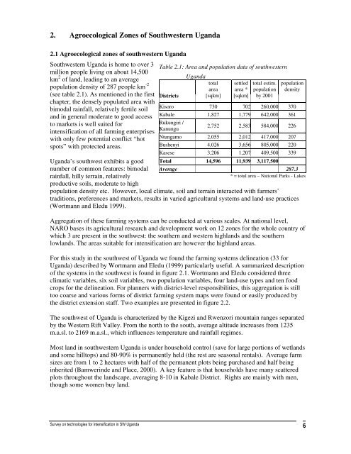
2. Agroecological Zones of Southwestern <strong>Uganda</strong><br />
2.1 Agroecological zones of southwestern <strong>Uganda</strong><br />
Southwestern <strong>Uganda</strong> is home to over 3<br />
million people liv<strong>in</strong>g on about 14,500<br />
km 2 of land, lead<strong>in</strong>g to an average<br />
population density of 287 people km -2<br />
(see table 2.1). As mentioned <strong>in</strong> the first<br />
chapter, the densely populated area with<br />
bimodal ra<strong>in</strong>fall, relatively fertile soil<br />
and <strong>in</strong> general moderate to good access<br />
to markets is well suited <strong>for</strong><br />
<strong><strong>in</strong>tensification</strong> of all farm<strong>in</strong>g enterprises<br />
with only few potential conflict “hot<br />
spots” with protected areas.<br />
<strong>Uganda</strong>’s southwest exhibits a good<br />
number of common features: bimodal<br />
ra<strong>in</strong>fall, hilly terra<strong>in</strong>, relatively<br />
productive soils, moderate to high<br />
Table 2.1: Area and population data of southwestern<br />
Districts<br />
<strong>Uganda</strong><br />
total<br />
area<br />
[sqkm]<br />
settled<br />
area *<br />
[sqkm]<br />
total estim.<br />
population<br />
by 2001<br />
population<br />
density<br />
Kisoro 730 702 260,000 370<br />
Kabale 1,827 1,779 642,000 361<br />
Rukungiri /<br />
Kanungu<br />
2,752 2,583 584,000 226<br />
Ntungamo 2,055 2,012 417,000 207<br />
Bushenyi 4,026 3,656 805,000 220<br />
Kasese 3,206 1,207 409,500 339<br />
Total 14,596 11,939 3,117,500<br />
Average 287.3<br />
* = total area – National Parks - Lakes<br />
population density etc. However, local climate, soil and terra<strong>in</strong> <strong>in</strong>teracted with farmers’<br />
traditions, preferences and markets, results <strong>in</strong> varied agricultural systems and land-use practices<br />
(Wortmann and Eledu 1999).<br />
Aggregation of these farm<strong>in</strong>g systems can be conducted at various scales. At national level,<br />
NARO bases its agricultural research and development work on 12 zones <strong>for</strong> the whole country of<br />
which 3 are present <strong>in</strong> the southwest: the southern and western highlands and the southern<br />
lowlands. The areas suitable <strong>for</strong> <strong><strong>in</strong>tensification</strong> are however the highland areas.<br />
For this study <strong>in</strong> the southwest of <strong>Uganda</strong> we found the farm<strong>in</strong>g systems del<strong>in</strong>eation (33 <strong>for</strong><br />
<strong>Uganda</strong>) described by Wortmann and Eledu (1999) particularly useful. A summarized description<br />
of the systems <strong>in</strong> the southwest is found <strong>in</strong> figure 2.1. Wortmann and Eledu considered three<br />
climatic variables, six soil variables, two population variables, four land-use types and ten food<br />
crops <strong>for</strong> the del<strong>in</strong>eation. For planners with district-level responsibilities, this aggregation is still<br />
too coarse and various <strong>for</strong>ms of district farm<strong>in</strong>g system maps were found or easily produced by<br />
the district extension staff. Two examples are presented <strong>in</strong> figure 2.2.<br />
The southwest of <strong>Uganda</strong> is characterized by the Kigezi and Rwenzori mounta<strong>in</strong> ranges separated<br />
by the Western Rift Valley. From the north to the south, average altitude <strong>in</strong>creases from 1235<br />
m.a.sl. to 2169 m.a.sl., which <strong>in</strong>fluences temperature and ra<strong>in</strong>fall regimes.<br />
Most land <strong>in</strong> southwestern <strong>Uganda</strong> is under household control (save <strong>for</strong> large portions of wetlands<br />
and some hilltops) and 80-90% is permanently held (the rest are seasonal rentals). Average farm<br />
sizes are from 1 to 2 hectares with half of the permanent plots be<strong>in</strong>g purchased and half be<strong>in</strong>g<br />
<strong>in</strong>herited (Bamwer<strong>in</strong>de and Place, 2000). A key feature is that households have many scattered<br />
plots throughout the landscape, averag<strong>in</strong>g 8-10 <strong>in</strong> Kabale District. Rights are ma<strong>in</strong>ly with men,<br />
though some women buy land.