Fernerkundung I (Digitale Bildverarbeitung) - Friedrich-Schiller ...
Fernerkundung I (Digitale Bildverarbeitung) - Friedrich-Schiller ...
Fernerkundung I (Digitale Bildverarbeitung) - Friedrich-Schiller ...

You also want an ePaper? Increase the reach of your titles
YUMPU automatically turns print PDFs into web optimized ePapers that Google loves.
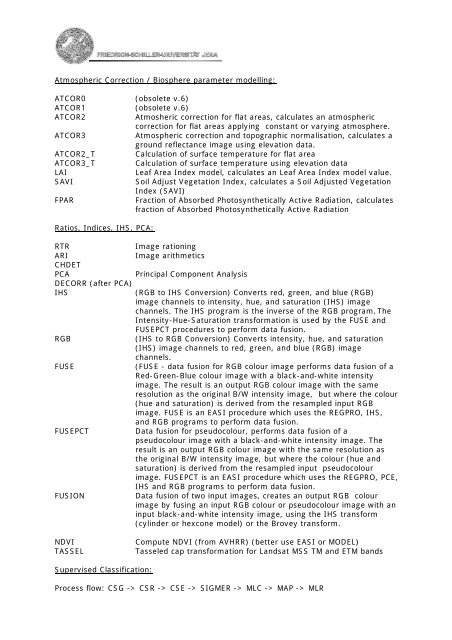
Atmospheric Correction / Biosphere parameter modelling:<br />
ATCOR0<br />
ATCOR1<br />
ATCOR2<br />
ATCOR3<br />
ATCOR2_T<br />
ATCOR3_T<br />
LAI<br />
SAVI<br />
FPAR<br />
(obsolete v.6)<br />
(obsolete v.6)<br />
Atmosheric correction for flat areas, calculates an atmospheric<br />
correction for flat areas applying constant or varying atmosphere.<br />
Atmospheric correction and topographic normalisation, calculates a<br />
ground reflectance image using elevation data.<br />
Calculation of surface temperature for flat area<br />
Calculation of surface temperature using elevation data<br />
Leaf Area Index model, calculates an Leaf Area Index model value.<br />
Soil Adjust Vegetation Index, calculates a Soil Adjusted Vegetation<br />
Index (SAVI)<br />
Fraction of Absorbed Photosynthetically Active Radiation, calculates<br />
fraction of Absorbed Photosynthetically Active Radiation<br />
Ratios, Indices, IHS, PCA:<br />
RTR<br />
ARI<br />
CHDET<br />
PCA<br />
DECORR (after PCA)<br />
IHS<br />
RGB<br />
FUSE<br />
FUSEPCT<br />
FUSION<br />
Image rationing<br />
Image arithmetics<br />
Principal Component Analysis<br />
(RGB to IHS Conversion) Converts red, green, and blue (RGB)<br />
image channels to intensity, hue, and saturation (IHS) image<br />
channels. The IHS program is the inverse of the RGB program. The<br />
Intensity-Hue-Saturation transformation is used by the FUSE and<br />
FUSEPCT procedures to perform data fusion.<br />
(IHS to RGB Conversion) Converts intensity, hue, and saturation<br />
(IHS) image channels to red, green, and blue (RGB) image<br />
channels.<br />
(FUSE - data fusion for RGB colour image performs data fusion of a<br />
Red-Green-Blue colour image with a black-and-white intensity<br />
image. The result is an output RGB colour image with the same<br />
resolution as the original B/W intensity image, but where the colour<br />
(hue and saturation) is derived from the resampled input RGB<br />
image. FUSE is an EASI procedure which uses the REGPRO, IHS,<br />
and RGB programs to perform data fusion.<br />
Data fusion for pseudocolour, performs data fusion of a<br />
pseudocolour image with a black-and-white intensity image. The<br />
result is an output RGB colour image with the same resolution as<br />
the original B/W intensity image, but where the colour (hue and<br />
saturation) is derived from the resampled input pseudocolour<br />
image. FUSEPCT is an EASI procedure which uses the REGPRO, PCE,<br />
IHS and RGB programs to perform data fusion.<br />
Data fusion of two input images, creates an output RGB colour<br />
image by fusing an input RGB colour or pseudocolour image with an<br />
input black-and-white intensity image, using the IHS transform<br />
(cylinder or hexcone model) or the Brovey transform.<br />
NDVI<br />
TASSEL<br />
Compute NDVI (from AVHRR) (better use EASI or MODEL)<br />
Tasseled cap transformation for Landsat MSS TM and ETM bands<br />
Supervised Classification:<br />
Process flow: CSG -> CSR -> CSE -> SIGMER -> MLC -> MAP -> MLR