Hull Street Road Revitalization Plan - College of Humanities and ...
Hull Street Road Revitalization Plan - College of Humanities and ...
Hull Street Road Revitalization Plan - College of Humanities and ...

You also want an ePaper? Increase the reach of your titles
YUMPU automatically turns print PDFs into web optimized ePapers that Google loves.
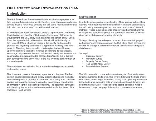
<strong>Hull</strong> <strong>Street</strong> <strong>Road</strong> <strong>Revitalization</strong> <strong>Plan</strong><br />
I. Introduction<br />
The <strong>Hull</strong> <strong>Street</strong> <strong>Road</strong> <strong>Revitalization</strong> <strong>Plan</strong> is a tool whose purpose is to<br />
help to guide future development in the study area. Its recommendations<br />
seek to infuse a new sense <strong>of</strong> vitality into this aging regional corridor that<br />
is located near a number <strong>of</strong> competitive retail markets.<br />
At the request <strong>of</strong> both Chesterfield County’s Department <strong>of</strong> Community<br />
<strong>Revitalization</strong> <strong>and</strong> the City <strong>of</strong> Richmond’s Department <strong>of</strong> Community<br />
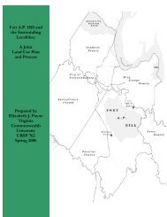
Development, the VCU study team examined the portion <strong>of</strong> <strong>Hull</strong> <strong>Street</strong><br />
<strong>Road</strong> that spans both localities—from Warwick <strong>Road</strong> in the city to<br />
the Route 360 West Shopping Center in the county, <strong>and</strong> across the<br />
physical <strong>and</strong> psychological divide <strong>of</strong> Chippenham Parkway. See map,<br />
page 11. The study team strived to create a plan that would seize<br />
upon the corridor’s strengths, minimize or eliminate its weaknesses,<br />
encourage unity between the two localities <strong>and</strong> identify unique economic<br />
opportunities available along the corridor. Significantly, this is the first<br />
plan developed as the direct result <strong>of</strong> the two localities’ collaboration on<br />
a shared corridor.<br />
The study team was asked to focus primarily on design <strong>and</strong> economic<br />
restructuring issues.<br />
Study Methods<br />
In order to gain a greater underst<strong>and</strong>ing <strong>of</strong> how various stakeholders<br />
view the <strong>Hull</strong> <strong>Street</strong> <strong>Road</strong> corridor <strong>and</strong> how it functions economically,<br />
the VCU study team designed <strong>and</strong> employed a number <strong>of</strong> research<br />
methods. These included a series <strong>of</strong> surveys <strong>and</strong> a market analysis<br />
<strong>of</strong> supply <strong>and</strong> dem<strong>and</strong> for goods <strong>and</strong> services in the area, as well as<br />
observation <strong>of</strong> design <strong>and</strong> physical elements.<br />
To begin, the study team designed a series <strong>of</strong> surveys that gauged<br />
participants’ general impressions <strong>of</strong> the <strong>Hull</strong> <strong>Street</strong> <strong>Road</strong> corridor <strong>and</strong><br />
desires for change. A different survey was used for each category <strong>of</strong><br />
stakeholders:<br />
Surveys 1<br />
• Customer Survey<br />
• Merchant Survey<br />
• Property Owner Survey<br />
• Real Estate Agent Survey<br />
• Pastor/Minister Survey<br />
This document presents the research process <strong>and</strong> the plan. The first<br />
section covers background <strong>and</strong> history, existing studies <strong>and</strong> methods.<br />
The following section provides an overview <strong>of</strong> the study area. The next<br />
section examines the corridor’s strengths, weaknesses, opportunities<br />
<strong>and</strong> threats in light <strong>of</strong> the existing conditions. The document concludes<br />
with the study team’s vision <strong>and</strong> recommendations for the future <strong>of</strong> the<br />
<strong>Hull</strong> <strong>Street</strong> <strong>Road</strong> corridor.<br />
The VCU team also conducted a market analysis <strong>of</strong> the study area’s<br />
larger convenience trade area. This involved drawing the trade area’s<br />
boundaries, conducting a windshield survey <strong>of</strong> all operating businesses<br />
in the trade area, collecting data on product supply <strong>and</strong> dem<strong>and</strong>, <strong>and</strong><br />
determining <strong>Hull</strong> <strong>Street</strong> <strong>Road</strong>’s ability to absorb additional types <strong>of</strong><br />
businesses. 2 Map 1 on page 5 shows the convenience trade area.<br />
Page 4<br />
1<br />
Refer to Appendix C for survey instruments <strong>and</strong> quantitative results<br />
2<br />
Refer to Appendix E for detailed market analysis results <strong>and</strong> trade area