
You also want an ePaper? Increase the reach of your titles
YUMPU automatically turns print PDFs into web optimized ePapers that Google loves.
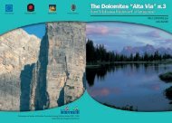
From the peak of Kreuzspitze walk over the mountain ridge<br />
secured with wire cables and continue down towards the south<br />
along the large crest to Rosenjoch (pass lies at 2,796m). Climb down<br />
the ridge us<strong>ing</strong> an easy climb<strong>ing</strong> section and go up to the peak of<br />
Grünberg (2,790m). Proceed further along path No. 27 in an easterly<br />
direction towards to the top of Grafmartspitze (2,720m) and down<br />
to Navis Jöchl (2,479m) and follow the passage from Volder valley<br />
into the Navis valley. From the Navis pass hike along path No.<br />
331 over the Grafmartalm (2,162m) via alp grounds and down to<br />
Peeralm (1,663m) at the end of the Navis valley.<br />
3 hours from Kreuzspitze<br />
6 hours from Meißner mountain hut<br />
The Navis valley leads from Matrei into the Tuxer Alps. Opposite the shaded<br />
forested area, around one hundred farms lie strewn across the grass-covered slopes<br />
of the sunny side of the valley. High up in the mountains, 25 alpine pastures<br />
situated round the valley are farmed and the cattle spend the summer graz<strong>ing</strong> on<br />
the open alpine meadows. Navis is referred to as “Valley of Love” because the<br />
families there have so many children. Rumour has it that families were so large<br />
because of a lack of television sets. Two alpine huts on the alp and one of the<br />
highest ly<strong>ing</strong> farms in the valley offer accommodation. The huts are built in wooden<br />
chalet style reflect<strong>ing</strong> the traditional build<strong>ing</strong> methods of the region.<br />
Peeralm: run by the Peer family. Open: all year round. 6 in dormitory-style<br />
accommodation, 12 beds, Tel. +43 (0)5278 6282 www.peeralm.at<br />
Klammalm: run by the Geir family. Open from 1st June until 31st October.<br />
17 beds, Tel. +43 (0)5278 6240 or mobile phone +43 (0)664 1167320 or<br />
+43 (0)0664 1617077<br />
Liesenhof: run by the Halder family, Grün 10, 6143 Navis<br />
Farm: from the Peeralm along the forest road, approx. 30 minutes by foot<br />
head<strong>ing</strong> out of the valley, 20 beds Tel. +43 (0)5278 6295. www.liesenhof.at.gs<br />
Navis mountain hut, OEAV Academic Innsbruck Section, currently closed<br />
Tel. +43 (0)5278 6209 www.naviser-huette.at<br />
Gasthof Eppensteiner, Oberweg 21, A-6143 Navis; from the Peeralm on<br />
the forest path out of the valley, approx. 45 minutes; Tel. +43 (0)5278 6423<br />
(www.eppensteiner.at.tf)<br />
Alternative Route 4<br />
From Glungezer mountain hut to the peak of<br />
Kreuzspitze<br />
From the Glungezer hut walk south, pass<strong>ing</strong> the military camp to<br />
reach the Glungezer (2,677m). Hike along the crest to the Gamslahner<br />
(summit at 2,681m) and Kreuzspite. On this alternative route, there<br />
are several easy climbs secured with wire-cables.<br />
2 hours from Glungezer hut<br />
Third Stage<br />
From the Navis Almen (alp) into the high valley of<br />
Schmirn<br />
Altitude difference: ascent 940m; descent 1,140m<br />
Length of the path: approx. 9 km<br />
Hik<strong>ing</strong> time: 6 hours<br />
Paths:<br />
16, 18, 325, 16, 25, 25A, Landstrasse (road)<br />
Grade:<br />
EE<br />
From the Peeralm, walk along the track (No. 16 direction<br />
Klammalm) and enter the valley (eastwards). Cross the bridge situated<br />
above the Klamm brook and then, after 3 bends, turn left into the<br />
valley. Follow the trail over the lush alpine pastures and continue<br />
along the Klamm brook to Klammalm (1,947m)<br />
1 hours from Peeralm<br />
From the Klammalm, walk along the roadway, cross the brook<br />
and then turn left. Next, continue along trail No. 18 through the alpine<br />
pastures with a larch-filled forest lead<strong>ing</strong> out of the valley. Path<br />
No. 18 also meets path No. 325, which continues on a track lead<strong>ing</strong><br />
to the Navis hut.<br />
38 INNSBRUCK - BRIXEN - FELTRE EUROPA HIG--ALTITUDE TRAIL 2 39