
You also want an ePaper? Increase the reach of your titles
YUMPU automatically turns print PDFs into web optimized ePapers that Google loves.
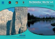
Viel Del Pan and Marmolada<br />
you come across the valley station of the Marmolada cable car with<br />
its three sections: the first reaches the 2,350m of altitude on the<br />
Antermoia, the second 2,950m on the Serauta, and the third 3,270m<br />
on the Punta Rocca. This is an excellent tourist route for those who<br />
want to combine a walk without any great physical effort and enjoy<br />
the beauty of the nature, which is readily available.<br />
From the Malga Ciapèla, follow path No. 610 (towards the west),<br />
past a camp<strong>ing</strong> site and near a rural tourist area. Subsequently slope<br />
begin to lead uphill. At 1,638m, path No. 610 heads uphill and to the<br />
right in the direction of Malga Ombretta; then turns left (towards the<br />
south). Path No. 689 branches off on to the cart path of the Val de<br />
Franzedàz. The path suddenly bends and leads through serpentine<br />
(towards the southwest) at an altitude of 1,950m. Here, the path goes<br />
left (towards the east) in direction of Franzedàz. Stay on this path<br />
(right) i.e. remain on the path number 689, which becomes a wellmaintained<br />
cart path and walk to the junction at 2,250m. Here, leave<br />
this path (it continues left towards the south, named the Alta via<br />
dei Pastori – The Shepherd’s Path) and take (right) the path No. 694<br />
(towards the southwest) which leads to some hairpin bends to the<br />
Forca Rossa, 2,490m, between Pizzo Le Crene and Col Becher..<br />
On the other side of the col head downwards, initially along path<br />
No. 694 for a short while until, at approx. 2,500m, you take path<br />
No. 670, which leads along a reddish slope down (towards the southwest)<br />
to Valfredda. Head now through some grassy hollows and<br />
finally, after a twist towards the northeast, you reach a small valley<br />
with numerous barns - a perfect area for walk<strong>ing</strong> and enjoy<strong>ing</strong> the<br />
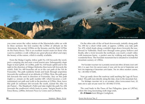
wonderful flora. The Furciàde mountain hut is situated in wonderful<br />
mountain scenery at 1,982m.<br />
The Furciàde mountain hut is privately owned and offers 18 beds (room with<br />
WC); it is open from the second week of June until the end of September and<br />
from the beginn<strong>ing</strong> of December until Easter. The inn offers excellent cuisine.<br />
Tel. +39 0462 574281.<br />
Now go easily down the roadway until reach<strong>ing</strong> the Lago di Pozze<br />
(lake). The path runs directly along the lake, close to the mountain hut.<br />
The Miralago mountain hut is run privately, offers home-cooked food, 25<br />
beds and is open all year round Tel +39 0462 573791.<br />
The road leads to the Passo di San Pellegrino, (pass at 1,907m),<br />
where this long fascinat<strong>ing</strong> sixth stage ends.<br />
2 + 5 hours from Rifugio Castiglioni.<br />
94 INNSBRUCK - BRIXEN - FELTRE EUROPA HIG--ALTITUDE TRAIL 2 95