
Create successful ePaper yourself
Turn your PDF publications into a flip-book with our unique Google optimized e-Paper software.
From the Passo di San Pellegrino, take path No. 658 (marked on a<br />
stone and on a tree) opposite to the lifts of the Cima Uomo. This leads<br />
in a southeasterly direction through damp fields under the cable car<br />
from the Col Margherita. The path goes upwards (towards the southsoutheast)<br />
through a grassy landscape. You reach a ski slope and finally<br />
see the sparse alpine meadows of the Z<strong>ing</strong>ari Alti (Ladin: “Zìnghen”),<br />
which is littered with granite blocks. When it is foggy, you should be<br />
extra vigilant and check you are on the right path to avoid gett<strong>ing</strong> lost.<br />
In this area, it is very easy to lose your bear<strong>ing</strong>s and head off the trail.<br />
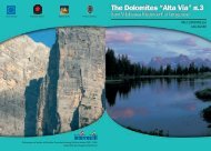
A long way below (towards the east) you can see the bright surface<br />
of the beautiful lake Cavia.<br />
From the saddle at approx. 2,300m, descend towards the south,<br />
which offers a fantastic view of the Civetta, the Pelmo and the Tofane<br />
and ahead the glorious mountain group of the Pale di San Martino.<br />
South of the plateau, you reach the Forcella Pradazzo (col at 2,220m).<br />
Slightly eastwards of the col is the privately owned Laresèi hut (at 2,250<br />
m) which it is very invit<strong>ing</strong> and open dur<strong>ing</strong> the ski season and also from June<br />
to October, offer<strong>ing</strong> home-cooked food and approx. 20 beds; Tel. +39 0437<br />
599 000.<br />
Still on path No. 658, head downwards, partly on a road, partly on a<br />
path to the Malga Pradazzo alpine hut until arriv<strong>ing</strong> after a short while<br />
at the Passo Valles (pass at 2,031m).<br />
2 hours from Passo di San Pellegrino.<br />
From the Passo Valles, go down along path No. 751 (towards the<br />
east). This path heads uphill on the northern slopes of the Cima<br />
Venegia at 2,217m and reaches the Forcella Venegia (col at 2,217m),<br />
where you are in direct contact with the border of the national park:<br />
“Parco Naturale di Paneveggio e delle Pale di San Martino”. The crest<br />
is initially covered in earth and then grass and the path leads down<br />
into a basin with a small mountain lake. On the banks of this lake you<br />
may be lucky enough to watch a family of Marmots, which form part<br />
of unique, fairytale landscape! Cross the eastern slope and then the<br />
southern slope of the Cima Venegiota where you reach the Passo di<br />
Venegiota (pass at 2,303m), and walk towards the east in order to reach<br />
Passo dei Fochèt from Focobòn at 2,291m. From here, path No. 751<br />
heads up the slope (towards the southeast) and then flattens out for a<br />
short period. Climb downwards over a scree and go further upwards<br />
along a ridge. Go along the eastern slopes of the Monte Mulàz and<br />
higher over the Valle del Focobòn, where the spectacular Dolomite<br />
range, the Lastei and the tops of Focobòn rise. From a hollow covered<br />
with snow, climb up to any area full of greenery. Hik<strong>ing</strong> through<br />
declines, terrac<strong>ing</strong> and an old glacier with stone plates, you reach a<br />
little saddle, Passo Arduini. From here, the path drops downwards<br />
after hav<strong>ing</strong> crossed a small plateau. You reach the Giuseppe Volpi di<br />
Misurata - Mulàz mountain hut at 2,571m.<br />
5 hours from Passo Valles<br />
7 hours from Passo di San Pellegrino<br />
The Mulàz mountain hut is a beautiful build<strong>ing</strong> with two floors. The owner<br />
is the Venetian Division of the Italian Alpine Club. It was built in 1907 and<br />
renovated in 2000. It is open from 20th June until 20th September and offers<br />
home-cooked food, 39 beds, refuge in winter with 12 places in dormitory and<br />
a telephone in case of an emergency; light produced by power unit; toilet, hot<br />
water and shower. It is also a station of the mountain rescue service CNSAS<br />
“118“: Tel. +39 0437 599420.<br />
Eighth Stage<br />
From the Volpi mountain hut - Mulàz to the Pedrotti<br />
mountain hut at Rosetta<br />
Altitude difference: ascent 760m; descent 750m<br />
Length of the path: approx. 8 km<br />
Hik<strong>ing</strong> time: 5 hours<br />
Path: No. 703<br />
Grade:<br />
EE and EEA on the section Sentiero delle Faràngole<br />
This stage is for experienced mountaineers only, particularly on the<br />
famous “Faràngole” path, which is exposed but well secured with wirecables.<br />
When there is a lot of snow, particularly at the beginn<strong>ing</strong> of the<br />
season, the ropes could still be covered with snow, mak<strong>ing</strong> this section<br />
very difficult. It is recommended to take a rope to secure the way for less<br />
experienced hikers or leaders. Also to be recommended are an axe for<br />
100 INNSBRUCK - BRIXEN - FELTRE EUROPA HIG--ALTITUDE TRAIL 2 101