
You also want an ePaper? Increase the reach of your titles
YUMPU automatically turns print PDFs into web optimized ePapers that Google loves.
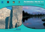
Diavolo (in Ladin “Diàol” means “Devil’s Place”). Everyth<strong>ing</strong> is<br />
covered here with enormous boulders, with stones of different forms<br />
that look as if they have been decorated with arabesques and are<br />
marked by the effects of the wind and mist dur<strong>ing</strong> over thousands<br />
of years. As this area looks as if an earthquake has hit it, and gives<br />
you a real impression that you are near the residence of the devil, as<br />
rumour has it in the valley.<br />
After the Devil’s Place, continue over the green hollow of the alpine<br />
meadows of the Busa di Piètena; (here one can see a strange rock formation<br />
in the shape of a book). This region is rich in fossils (it is forbidden<br />
here even to touch them because you are still in the nature reserve).<br />
Go further along the cart path, which heads slowly upwards at approx<br />
2,050m, northwest of the Piètena pass.<br />
Some massive stone blocks in the immediate proximity make you<br />
think of some ancient and puzzl<strong>ing</strong> prehistoric monuments left here by<br />
some mysterious lost civilisation.<br />
From the pass, continue to head southwest. The cart path begins<br />
after a narrow bend and climbs in the direction of another “Busa”<br />
(depression in the land) named Busa delle Vette. This large, very green<br />
meadow in the high mountains is broken up by white scree over the<br />
slopes, offer<strong>ing</strong> a remarkable variety of flora.<br />
Continu<strong>ing</strong> at the same altitude on the Vette Grande for a while, it<br />
weaves effortlessly upwards along a narrow road to the Vette Grande<br />
pass at 1,994m. This pass represents the last col of the High-Altitude<br />
Trail – from here on it’s downhill all the way.<br />
South of the pass, you can quickly reach the “Giorgio Dal Piaz“<br />
mountain hut (1,993m).<br />
7 hours from the Boz mountain hut.<br />
The Refugio Giorgio Dal Piaz is a beautiful stone build<strong>ing</strong> built in<br />
1963; it belongs to the Feltre Division of the Italian Alpine Club and<br />
offers home-cooked food and 22 beds; with water supply. Open from<br />
20th June until 20th September. Refuge in winter with six places in a<br />
dormitory. Electricity produced us<strong>ing</strong> solar panels. Tel. +39 0439 9065<br />
Thirteenth Stage<br />
From the Dal Piaz mountain hut to Croce d’Aune and<br />
to Feltre<br />
Altitude difference: descent 980m until Croce d’Àune, 1,670m until Feltre<br />
Length of the path: approx. 19 km<br />
Hik<strong>ing</strong> time: 6 hours until Feltre<br />
Paths:<br />
No. 801 and asphalted road<br />
Grade:<br />
E and T<br />
From the Dal Piaz hut, take either path No. 801, which directly<br />
descends towards the south, or the narrow military road. This road<br />
is just as convenient but a bit longer. The path shortens the distance,<br />
because it does not go along the numerous bends but leads<br />
directly down over meadows and rocks. The path becomes challeng<strong>ing</strong><br />
later in the walk, but it remains easy to pass. The path winds<br />
downwards for quite a long way, cross<strong>ing</strong> the forest. At the Col dei<br />
Cavài (Pferdehügel) at 1,472m, path No. 801 leads you out of the<br />
nature reserve and heads west, and finally, after a bend towards<br />
the south, br<strong>ing</strong>s you into the large saddle of the Passo di Croce<br />
d’Aune. (pass at 1,015m). This pass lies between the slightly hilly<br />
depression in the ground of Pedavena and Cismon valley. Here you<br />
will find an assortment of hotels, restaurants and shops.<br />
It is here that your outdoor adventure along High-Altitude Trail<br />
Number 2, set against stunn<strong>ing</strong> mountain scenery, ends. Those who<br />
wish to can continue along the path on foot.<br />
Pedavena and Feltre can be reached with the public bus service<br />
(look out for timetables) but also by foot. Of course, the purists can<br />
walk along the relatively uninterest<strong>ing</strong> 473 main road for around 9<br />
km to Pedavena and another 4 km to Feltre.<br />
In Pedavena (359m) you have the chance to have a refresh<strong>ing</strong><br />
beer - as long as you do not arrive to find that the local brewery has<br />
closed! (There was talk of clos<strong>ing</strong> the Heineken brewery at the end<br />
120 INNSBRUCK - BRIXEN - FELTRE EUROPA HIG--ALTITUDE TRAIL 2 121