

East Mountain Trails & Bikeways Master Plan - Bernalillo County
East Mountain Trails & Bikeways Master Plan - Bernalillo County
East Mountain Trails & Bikeways Master Plan - Bernalillo County

You also want an ePaper? Increase the reach of your titles
YUMPU automatically turns print PDFs into web optimized ePapers that Google loves.
3. Soils<br />
The soils in the area fall into approximately two<br />
categories:<br />
1. Rock outcrops and rocky soils such as those<br />
in the Borolls, Escabosa, Kolob, La Porte,<br />
Pino, and Rock Outcrop series, which are<br />
typically found in the mountainous areas.<br />
2. Alluvial soils such as those in the Bluepoint,<br />
Brazito, Burnac, Carlito, Embudo, Gila,<br />
Kolob, La Fonda, Salas, Sandia, Scholle,<br />
Seis, Silver, Tesajo, Tijeras and Wink series,<br />
which are typically found on the mesa, high<br />
plains and riparian areas. High clay content<br />
soils such as those in the Bluepoint series<br />
and rock content soils such as those in the<br />
Borolls, La Porte, Kolob, and Rock Outcrop<br />
series present challenges to trail construction<br />
for most users. Rock outcrop areas with little<br />
or no vegetation are preferable for off-road<br />
vehicle (Jeep) users.<br />
Figure 4 shows areas with soils that will not<br />
readily support trails in red, Category 1, and<br />
areas with moderate challenges to trail<br />
construction in orange, Category 2, and areas<br />
with no limitation for trails in blue, Category 3.<br />
4. Hydrology<br />
The Project Area has a number of<br />
arroyos, which have cut beautiful<br />
canyons. The most notable of these are<br />
the Tijeras Arroyo, the San Antonio<br />
Arroyo, San Pedro Creek, and the Otero<br />
Canyon Arroyo. Some of the arroyos<br />
have sources in springs such as Carlito<br />
Springs, Ojito and Tres Pistolas. These<br />
hydrologic features are perennial during<br />
an average year. The arroyos are<br />
wettest during the spring runoff and<br />
summer monsoon months, when they<br />
are deluged by flash flooding in the<br />
aftermath of powerful thunderstorms.<br />
The arroyos are rich habitat areas and<br />
function as key wildlife corridors from the<br />
mountain and upland areas to the<br />
riparian and bottomland areas. The arroyos also<br />
often provided the route for early trails and cart<br />
paths. Because of the hydrologic and ecological<br />
functions of the arroyos, trails in arroyo bottom<br />
areas should be moved to outside the riparian<br />
zone. Springs and views of arroyos are important<br />
potential destination points and interpretive areas<br />
for a trail system. The map in Figure 5 identifies<br />
important arroyos and creeks. Figure 5 also<br />
shows major vegetation communities.<br />
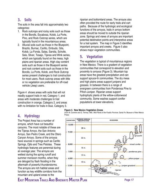
5. Vegetation<br />
The vegetation is typical of mountainous regions<br />
in New Mexico. There is a gradient of vegetation<br />
communities that correspond to elevation and<br />
proximity to arroyos (Figure 3). <strong>Mountain</strong> top<br />
areas have the greatest precipitation and can<br />
support spruce-fir communities. The dry mesa<br />
and high plains areas support junipers and<br />
grasses. In between there is a range of<br />
evergreen communities from Ponderosa Pine to<br />
Piñon-Juniper. Riparian areas support<br />
hydrophytic plants of the willow-cottonwood<br />
community. Some washes support conifer<br />
populations at lower elevations.<br />
Figure 3. New Mexico Vegetation Zones<br />
(from W. Dunmire and G. Tierney 1995. Wild <strong>Plan</strong>ts of the Pueblo Province. Santa Fe: Museum of New Mexico<br />
Press)<br />
EAST MOUNTAIN TRAILS AND BIKEWAYS MASTER PLAN Page 17


