

East Mountain Trails & Bikeways Master Plan - Bernalillo County
East Mountain Trails & Bikeways Master Plan - Bernalillo County
East Mountain Trails & Bikeways Master Plan - Bernalillo County

You also want an ePaper? Increase the reach of your titles
YUMPU automatically turns print PDFs into web optimized ePapers that Google loves.
crossing the roadway. Recent research<br />
findings (“Safety Analysis of Marked Versus<br />
Unmarked Crosswalks in 30 Cities,” ITE<br />
Journal, January 2004) have resulted in<br />
recommendations for and against installing<br />
marked crosswalks and other pedestrian<br />
improvements at uncontrolled locations<br />
based on the roadway factors listed above.<br />
For instance, for a trail crossing at a two-lane<br />
road with a daily traffic volume less than<br />
9,000 vehicles per day and a speed limit over<br />
40 mph (as an example, the current condition<br />
on NM 337), an increase in pedestrian crash<br />
risk would be expected by installing a<br />
marked crosswalk without other pedestrian<br />
facility enhancements. The<br />
recommendations of the ITE Safety Analysis<br />
should be used as a guideline in selecting<br />
the appropriate treatment when designing<br />
trail crossings of roadways in the <strong>East</strong><br />
<strong>Mountain</strong> <strong>Trails</strong> and <strong>Bikeways</strong> <strong>Plan</strong> area.<br />
4. Multi-use Soft Surface <strong>Trails</strong> in<br />
Separate Rights of Way or<br />
Easements<br />
• Paved Multi-use <strong>Trails</strong> may also be<br />
developed in separate rights of way or<br />
easements, reducing potential conflicts with<br />
motor vehicles to crossing locations.<br />
• Soft Surface <strong>Trails</strong> in separate rights-of-way<br />
on private property easements may occur in<br />
utility corridors, as local connections to<br />
subdivisions, including fire access roads<br />
and/or utility access roads doubling as trail<br />
access, or connections to and between<br />
destinations, including public lands with trail<br />
systems managed by various agencies.<br />
Most will be multi-use, serving a variety of<br />
users. Some may be signed to restrict user<br />
types. Motorized Off Highway Vehicles are<br />
restricted to designated roads, trails and<br />
areas. The <strong>Trails</strong> and <strong>Bikeways</strong> <strong>Master</strong> <strong>Plan</strong><br />
discusses needs of individual users in<br />
Chapter IV and the Technical Appendix. The<br />
USDA Forest Service Trail Construction and<br />
Maintenance Notebook provides guidance<br />
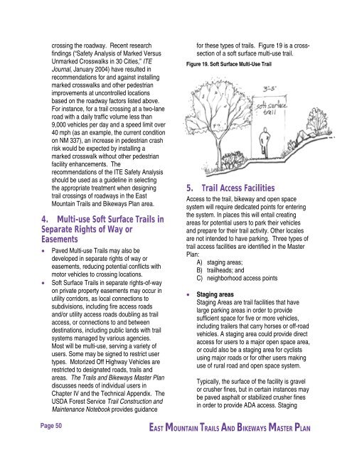
for these types of trails. Figure 19 is a crosssection<br />
of a soft surface multi-use trail.<br />
Figure 19. Soft Surface Multi-Use Trail<br />
5. Trail Access Facilities<br />
Access to the trail, bikeway and open space<br />
system will require dedicated points for entering<br />
the system. In places this will entail creating<br />
areas for potential users to park their vehicles<br />
and prepare for their trail activity. Other locales<br />
are not intended to have parking. Three types of<br />
trail access facilities are identified in the <strong>Master</strong><br />
<strong>Plan</strong>:<br />
A) staging areas;<br />
B) trailheads; and<br />
C) neighborhood access points<br />
• Staging areas<br />
Staging Areas are trail facilities that have<br />
large parking areas in order to provide<br />
sufficient space for five or more vehicles,<br />
including trailers that carry horses or off-road<br />
vehicles. A staging area could provide direct<br />
access for users to a major open space area,<br />
or could also be a staging area for cyclists<br />
using major roads or for other users making<br />
use of rural road and open space system.<br />
Typically, the surface of the facility is gravel<br />
or crusher fines, but in certain instances may<br />
be paved asphalt or stabilized crusher fines<br />
in order to provide ADA access. Staging<br />
Page 50<br />
EAST MOUNTAIN TRAILS AND BIKEWAYS MASTER PLAN


