

East Mountain Trails & Bikeways Master Plan - Bernalillo County
East Mountain Trails & Bikeways Master Plan - Bernalillo County
East Mountain Trails & Bikeways Master Plan - Bernalillo County

You also want an ePaper? Increase the reach of your titles
YUMPU automatically turns print PDFs into web optimized ePapers that Google loves.
area and the Estancia Vista area on the eastern<br />
edge of the <strong>County</strong>.<br />
Section F. Existing <strong>East</strong> <strong>Mountain</strong><br />
<strong>Trails</strong> & <strong>Bikeways</strong> Facilities<br />
There is no single map that accurately shows all<br />
existing trails, nor is there a comprehensive<br />
inventory other than the trail map developed by<br />
Charlie Ervin of Two Wheel Drive. The following<br />
assessment was prepared by project team<br />
members with input from the community, the<br />
Steering Committee, the Technical Team and<br />
stakeholders. Except where trails have been<br />
formally designated, the aggregate of this input is<br />
referred to as Undesignated Potential <strong>Trails</strong>.<br />
Some existing dirt and gravel roads that function<br />
as trails are being designated and adopted<br />
formally as trails as part of this plan.<br />
1. <strong>Bikeways</strong> within Roadway<br />
Rights-of-Way<br />
Roadways identified by the public as existing or<br />
potential on-street bicycle routes were reviewed<br />
by members of the project team on Saturday<br />
morning, February 21, 2004, as more bike riders<br />
were expected to be out riding on a Saturday<br />
than a weekday. Cold and snowy weather,<br />
however, resulted in only one bike rider and three<br />
walkers being observed on the roads. Typically,<br />
however, fair weather weekends see a number of<br />
road bicyclists pedaling from Albuquerque along<br />
NM 333 through Tijeras Canyon, north on NM 14<br />
to the Crest Highway or Frost Road or continuing<br />
along the NM 333 shoulder parallel to I-40.<br />
Observations of the team members are<br />
summarized below. Where available, two-way<br />
average weekday traffic volume (AWDT) for<br />
2002, collected by the Mid-Region Council of<br />
Governments is shown.<br />
The following roads have fairly wide shoulders<br />
(four to six feet plus):<br />
• NM 337 (“South 14”) between I-40 and NM<br />
217 ( <strong>Mountain</strong> Valley Road), AWDT 1,900-<br />
5,400 vehicles)<br />
• NM 333 (“Old Route 66”) from Albuquerque<br />
to NM 217 (AWDT 3,500-7,100 vehicles)<br />
• NM 536 (the “Crest Highway,” AWDT 400-<br />
1,600 vehicles)<br />
The problem with shoulder use—quite noticeable<br />
during the field visit—is maintenance; in<br />
particular, keeping the shoulders free of debris.<br />
At the time of the field visit, the shoulders were<br />
covered with de-icing material moved by<br />
snowplows, making the shoulders impassable for<br />
a road bike. During the public process, users also<br />
complained of rocks, trash, and shoulder damage<br />
during and after sewer line construction.<br />
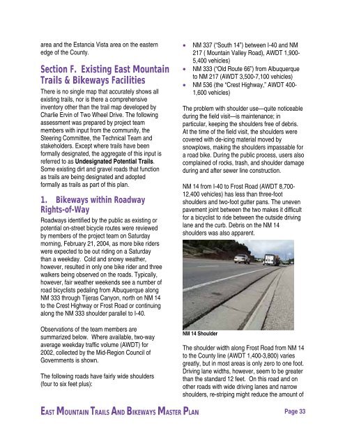
NM 14 from I-40 to Frost Road (AWDT 8,700-<br />
12,400 vehicles) has less than three-foot<br />
shoulders and two-foot gutter pans. The uneven<br />
pavement joint between the two makes it difficult<br />
for a bicyclist to ride between the outside driving<br />
lane and the curb. Debris on the NM 14<br />
shoulders was also apparent.<br />
NM 14 Shoulder<br />
The shoulder width along Frost Road from NM 14<br />
to the <strong>County</strong> line (AWDT 1,400-3,800) varies<br />
greatly, but in most areas is only zero to one foot.<br />
Driving lane widths, however, seem to be greater<br />
than the standard 12 feet. On this road and on<br />
other roads with wide driving lanes and narrow<br />
shoulders, re-striping might reduce the amount of<br />
EAST MOUNTAIN TRAILS AND BIKEWAYS MASTER PLAN Page 33


