

East Mountain Trails & Bikeways Master Plan - Bernalillo County
East Mountain Trails & Bikeways Master Plan - Bernalillo County
East Mountain Trails & Bikeways Master Plan - Bernalillo County

You also want an ePaper? Increase the reach of your titles
YUMPU automatically turns print PDFs into web optimized ePapers that Google loves.
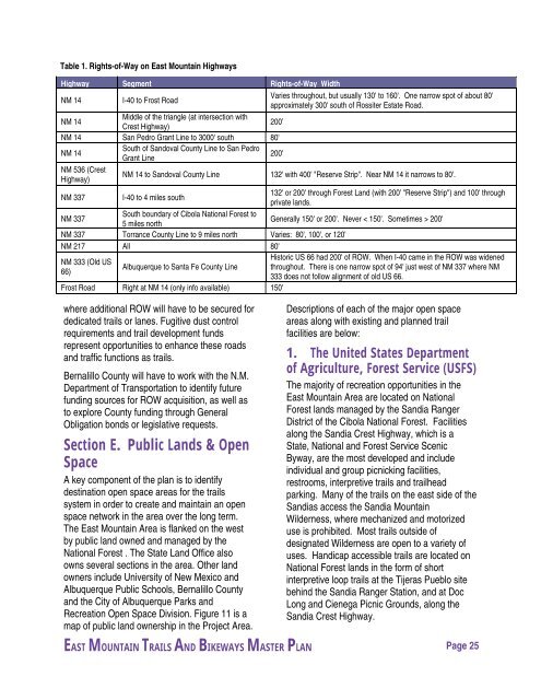
Table 1. Rights-of-Way on <strong>East</strong> <strong>Mountain</strong> Highways<br />
Highway Segment Rights-of-Way Width<br />
NM 14<br />
I-40 to Frost Road<br />
Varies throughout, but usually 130' to 160'. One narrow spot of about 80'<br />
approximately 300' south of Rossiter Estate Road.<br />
NM 14<br />
Middle of the triangle (at intersection with<br />
Crest Highway)<br />
200’<br />
NM 14 San Pedro Grant Line to 3000' south 80'<br />
NM 14<br />
South of Sandoval <strong>County</strong> Line to San Pedro<br />
Grant Line<br />
200'<br />
NM 536 (Crest<br />
Highway)<br />
NM 14 to Sandoval <strong>County</strong> Line<br />
132' with 400' "Reserve Strip". Near NM 14 it narrows to 80'.<br />
NM 337 I-40 to 4 miles south<br />
132' or 200' through Forest Land (with 200' "Reserve Strip") and 100' through<br />
private lands.<br />
NM 337<br />
South boundary of Cibola National Forest to<br />
5 miles north<br />
Generally 150' or 200'. Never < 150'. Sometimes > 200'<br />
NM 337 Torrance <strong>County</strong> Line to 9 miles north Varies: 80', 100', or 120'<br />
NM 217 All 80'<br />
Historic US 66 had 200' of ROW. When I-40 came in the ROW was widened<br />
NM 333 (Old US<br />
Albuquerque to Santa Fe <strong>County</strong> Line throughout. There is one narrow spot of 94' just west of NM 337 where NM<br />
66)<br />
333 does not follow alignment of old US 66.<br />
Frost Road Right at NM 14 (only info available) 150'<br />
where additional ROW will have to be secured for<br />
dedicated trails or lanes. Fugitive dust control<br />
requirements and trail development funds<br />
represent opportunities to enhance these roads<br />
and traffic functions as trails.<br />
<strong>Bernalillo</strong> <strong>County</strong> will have to work with the N.M.<br />
Department of Transportation to identify future<br />
funding sources for ROW acquisition, as well as<br />
to explore <strong>County</strong> funding through General<br />
Obligation bonds or legislative requests.<br />
Section E. Public Lands & Open<br />
Space<br />
A key component of the plan is to identify<br />
destination open space areas for the trails<br />
system in order to create and maintain an open<br />
space network in the area over the long term.<br />
The <strong>East</strong> <strong>Mountain</strong> Area is flanked on the west<br />
by public land owned and managed by the<br />
National Forest . The State Land Office also<br />
owns several sections in the area. Other land<br />
owners include University of New Mexico and<br />
Albuquerque Public Schools, <strong>Bernalillo</strong> <strong>County</strong><br />
and the City of Albuquerque Parks and<br />
Recreation Open Space Division. Figure 11 is a<br />
map of public land ownership in the Project Area.<br />
Descriptions of each of the major open space<br />
areas along with existing and planned trail<br />
facilities are below:<br />
1. The United States Department<br />
of Agriculture, Forest Service (USFS)<br />
The majority of recreation opportunities in the<br />
<strong>East</strong> <strong>Mountain</strong> Area are located on National<br />
Forest lands managed by the Sandia Ranger<br />
District of the Cibola National Forest. Facilities<br />
along the Sandia Crest Highway, which is a<br />
State, National and Forest Service Scenic<br />
Byway, are the most developed and include<br />
individual and group picnicking facilities,<br />
restrooms, interpretive trails and trailhead<br />
parking. Many of the trails on the east side of the<br />
Sandias access the Sandia <strong>Mountain</strong><br />
Wilderness, where mechanized and motorized<br />
use is prohibited. Most trails outside of<br />
designated Wilderness are open to a variety of<br />
uses. Handicap accessible trails are located on<br />
National Forest lands in the form of short<br />
interpretive loop trails at the Tijeras Pueblo site<br />
behind the Sandia Ranger Station, and at Doc<br />
Long and Cienega Picnic Grounds, along the<br />
Sandia Crest Highway.<br />
EAST MOUNTAIN TRAILS AND BIKEWAYS MASTER PLAN Page 25


