Annual Report 2009-2010 - Ministry Of Earth Sciences
Annual Report 2009-2010 - Ministry Of Earth Sciences
Annual Report 2009-2010 - Ministry Of Earth Sciences

You also want an ePaper? Increase the reach of your titles
YUMPU automatically turns print PDFs into web optimized ePapers that Google loves.
The work carried out by NCAOR, NIO and NIOT are summarised below:<br />
Organisation<br />
NCAOR<br />
Deep water<br />
beyond 500m<br />
Total area about<br />
1.5 million sq km<br />
3.1 lakh sq km<br />
area surveyed<br />
Shallow water<br />
up to 500m<br />
Total area about<br />
0.5 million sq km<br />
NIO - About 4000 sq km<br />
area surveyed<br />
NIOT - 8300 sq km area<br />
surveyed<br />
Area covered<br />
- Andaman and Nicobar, Lakshadweep<br />
off Marmagoa, off Bombay High and<br />
off Malpe, Karnataka coasts<br />
off Pulicat, Sri Harikota, Ennore,<br />
Cuddalore, Kovalam, Nagapattinam<br />
region etc.<br />
Major findings of the survey are presented below:<br />
i) The survey confined between Ninety east<br />
Ridge to its west and Andaman Trench in east,<br />
revealed the presence of a long river channel<br />
exhibiting meandering disposed more or less<br />
in NNW-SSE (North North West – South South<br />
East) direction.<br />
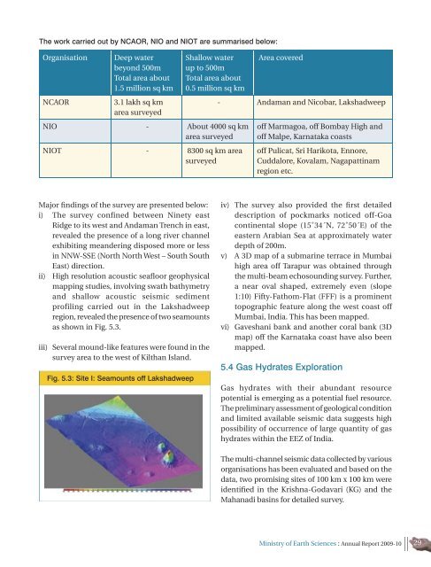
ii) High resolution acoustic seafloor geophysical<br />
mapping studies, involving swath bathymetry<br />
and shallow acoustic seismic sediment<br />
profiling carried out in the Lakshadweep<br />
region, revealed the presence of two seamounts<br />
as shown in Fig. 5.3.<br />
iii) Several mound-like features were found in the<br />
survey area to the west of Kilthan Island.<br />
Fig. 5.3: Site I: Seamounts off Lakshadweep<br />
iv) The survey also provided the first detailed<br />
description of pockmarks noticed off-Goa<br />
continental slope (15˚34´N, 72˚50´E) of the<br />
eastern Arabian Sea at approximately water<br />
depth of 200m.<br />
v) A 3D map of a submarine terrace in Mumbai<br />
high area off Tarapur was obtained through<br />
the multi-beam echosounding survey. Further,<br />
a near oval shaped, extremely even (slope<br />
1:10) Fifty-Fathom-Flat (FFF) is a prominent<br />
topographic feature along the west coast off<br />
Mumbai, India. This has been mapped.<br />
vi) Gaveshani bank and another coral bank (3D<br />
map) off the Karnataka coast have also been<br />
mapped.<br />
5.4 Gas Hydrates Exploration<br />
Gas hydrates with their abundant resource<br />
potential is emerging as a potential fuel resource.<br />
The preliminary assessment of geological condition<br />
and limited available seismic data suggests high<br />
possibility of occurrence of large quantity of gas<br />
hydrates within the EEZ of India.<br />
The multi-channel seismic data collected by various<br />
organisations has been evaluated and based on the<br />
data, two promising sites of 100 km x 100 km were<br />
identified in the Krishna-Godavari (KG) and the<br />
Mahanadi basins for detailed survey.<br />
<strong>Ministry</strong> of <strong>Earth</strong> <strong>Sciences</strong> : <strong>Annual</strong> <strong>Report</strong> <strong>2009</strong>-10 29