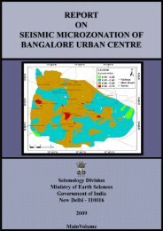
Annual Report 2009-2010 - Ministry Of Earth Sciences
Annual Report 2009-2010 - Ministry Of Earth Sciences
Annual Report 2009-2010 - Ministry Of Earth Sciences

You also want an ePaper? Increase the reach of your titles
YUMPU automatically turns print PDFs into web optimized ePapers that Google loves.
Meghalaya on 26 th and 27 th May. Apart from<br />
India and Bangladesh, Nepal also received<br />
heavy rain due to northward movement of<br />
the system.<br />
v) A storm surge of 3m (10ft) and 2m affected<br />
western regions of Bangladesh, Sunderban area,<br />
respectively submerging numerous villages.<br />
Cyclonic storm “PHYAN” over the Arabian Sea<br />
(9-12 November, <strong>2009</strong>)<br />
The cyclonic storm “PHYAN” developed over the<br />
southeast Arabian Sea in association with active<br />
northeast monsoon surge. A low pressure area<br />
formed over the Comorin area on 7 th November,<br />
<strong>2009</strong>. It concentrated in to a depression in the<br />
afternoon of 9 th November over southeast and<br />
the adjoining east central Arabian Sea, about<br />
70 km west of Amini Divi. It moved initially in a<br />
north-northwesterly direction till 10 th November<br />
morning and then recurved north-northeastwards.<br />
It intensified into a deep depression<br />
at 0830h IST and into a cyclonic storm ‘PHYAN’ at<br />
2330h IST of 10 th November, <strong>2009</strong>. Continuing its<br />
north-north-eastward movement, the cyclonic<br />
storm ‘PHYAN’ crossed the north Maharashtra<br />
coast between Alibag and Mumbai between<br />
1530h and 1630h IST of 11 th November. It moved<br />
then north-eastwards and weakened gradually<br />
into a well marked low pressure area over north<br />
Madhya Maharashtra and neighbourhood at<br />
0530h IST of 12 th November <strong>2009</strong>. The cyclone,<br />
‘PHYAN’ moved faster before crossing the coast.<br />
It moved about 450 km in 12 hours between<br />
0530h and 1730h IST of 11 th November, <strong>2009</strong><br />
(about 38 kmph). Widespread rainfall with<br />
isolated heavy to very heavy falls occurred over<br />
Goa, Konkan and Madhya Maharashtra on 10 th<br />
and 11 th . Fairly widespread rainfall also occurred<br />
over the south Gujarat region due to the cyclone<br />
on 11 th . Maximum surface wind was about 60-70<br />
km/h along the Maharashtra coast at the time of<br />
landfall. Though it crossed as a cyclonic storm, it<br />
slightly weakened before the landfall.<br />
Cyclone ‘WARD’ over the Bay of Bengal 10-15<br />
December, <strong>2009</strong><br />
The cyclone ‘WARD’ over the Bay of Bengal<br />
(10-15 December, <strong>2009</strong>) formed in association with<br />
an active inter-tropical convergence zone (ITCZ).<br />
A low pressure area formed over the southeast Bay<br />
of Bengal on 7 th December <strong>2009</strong>. It slowly moved<br />
westwards and intensified into a depression on<br />
14 th December afternoon over southwest and<br />
the adjoining southeast Bay of Bengal. It further<br />
intensified into a deep depression in the early<br />
morning of 11 th December. It then moved northward<br />
and intensified into a cyclonic storm ‘WARD’ in the<br />
same afternoon. It continued as a cyclonic storm<br />
and moved slowly northward till forenoon of 12 th<br />
December. It then moved west-southwestwards<br />
and weakened into a deep depression at midnight<br />
of 12 th December. Continuing to move in a westsouthwesterly<br />
direction, it crossed the northeast<br />
Sri Lanka coast close to the south of Trincomalee<br />
between 1330h and 1430h IST of 14 th December as a<br />
deep depression. It gradually weakened further into<br />
a well marked low pressure area over Sri Lanka in<br />
the morning, emerged into the Gulf of Mannar as a<br />
low pressure area in the evening of 15 th December<br />
and became less marked in the afternoon of 16 th<br />
December. Cyclone ‘WARD’ followed a rare track,<br />
as it moved initially in a northerly direction and<br />
then moved west-southwestwards across Sri Lanka.<br />
It was a slow moving system, as it travelled at the<br />
average rate of 200 km per day (8 km per hour). It<br />
weakened into deep depression over the sea before<br />
the landfall. In association with the cyclone, the<br />
northeast monsoon was vigorous over coastal Tamil<br />
Nadu and Puducherry during 13-16 th December<br />
<strong>2009</strong>. Widespread rainfall with isolated heavy to<br />
very heavy falls occurred over this region during<br />
this period.<br />
Average Landfall Forecast Error During <strong>2009</strong><br />
The average landfall forecast errors of cyclonic<br />
storms during <strong>2009</strong> based on the forecast issued<br />
are given in Table 9.1.<br />
56 <strong>Ministry</strong> of <strong>Earth</strong> <strong>Sciences</strong> : <strong>Annual</strong> <strong>Report</strong> <strong>2009</strong>-10