Annual Report 2009-2010 - Ministry Of Earth Sciences
Annual Report 2009-2010 - Ministry Of Earth Sciences
Annual Report 2009-2010 - Ministry Of Earth Sciences

Create successful ePaper yourself
Turn your PDF publications into a flip-book with our unique Google optimized e-Paper software.
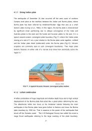
is an intra-cratonic rift, which formed due to<br />
lithosphere stretching between the Dharwar<br />
and Bastar cratons.<br />
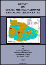
9.6.3 <strong>Earth</strong>quake Risk Evaluation<br />
<strong>Earth</strong>quake Risk Evaluation Centre (EREC)<br />
has been setup to guide national endeavour in<br />
mitigating the disasters impact of earthquake<br />
and undertake/promote scientific task related to<br />
earthquake risk evaluation. In this regard EREC<br />
has completed seismic microzonation of NCT of<br />
Delhi on 1:50,000 scale integrating several thematic<br />
maps viz. geotechnical, geological, seismological<br />
and site response etc. EREC is now in the process<br />
of generating such maps, at higher resolution on<br />
1:10,000 scale.<br />
60 <strong>Ministry</strong> of <strong>Earth</strong> <strong>Sciences</strong> : <strong>Annual</strong> <strong>Report</strong> <strong>2009</strong>-10