Book 4: Pinellas County Storm Tide Atlas - Tampa Bay Regional ...
Book 4: Pinellas County Storm Tide Atlas - Tampa Bay Regional ...
Book 4: Pinellas County Storm Tide Atlas - Tampa Bay Regional ...

Create successful ePaper yourself
Turn your PDF publications into a flip-book with our unique Google optimized e-Paper software.
Park<br />
Parking Lot<br />
75 75<br />
16.7 ft<br />
BEACH<br />
D<br />
27°47'0"N<br />
24<br />
Gulf Ln<br />
130th Ave<br />
82°47'0"W<br />
Boca Ciega Dr<br />
MADERIA<br />
D<br />
4.7 ft<br />
UV 699<br />
129th Ave<br />
Fishermans Aly<br />
128th Ave<br />
Boardwalk Pl<br />
Kingfish Dr<br />
127th Ave<br />
126th Ave<br />
Key Capri<br />
Sun Isle Cir<br />
121st<br />
Ave<br />
122nd Ave<br />
Capri<br />
120th Ave<br />
25<br />
1 25th Ave<br />
Cir<br />
Sun Vista Ct<br />
2nd St<br />
118th Ave<br />
117th Ave<br />
3rd St<br />
TREASURE ISLAND<br />
Sea Mist Dr<br />
116th Ave<br />
5th St<br />
4th St<br />
6th St<br />
115th Ave<br />
26<br />
82°46'0"W<br />
123rd Ave<br />
119th Ave<br />
7th St<br />
8th St<br />
9th St<br />
ST. PETERSBURG<br />
74 74<br />
27<br />
82°45'0"W<br />
El bow Ln<br />
Bogie Ave<br />
Park St<br />
Jungle Ave<br />
Par Ave<br />
G arden Dr<br />
Country Club<br />
Rd<br />
28<br />
Robinson Dr<br />
77th St<br />
16th<br />
Ave<br />
15th Ave<br />
14th Ave<br />
Russell Dr<br />
5th Ave<br />
Farragut Dr<br />
76th St<br />
27°47'0"N<br />
1st St<br />
Sunset Dr<br />
108th<br />
Alley<br />
Ave<br />
106th Ave<br />
Pl<br />
103rd Ave<br />
107th Ave<br />
Drive way<br />
104th Ave<br />
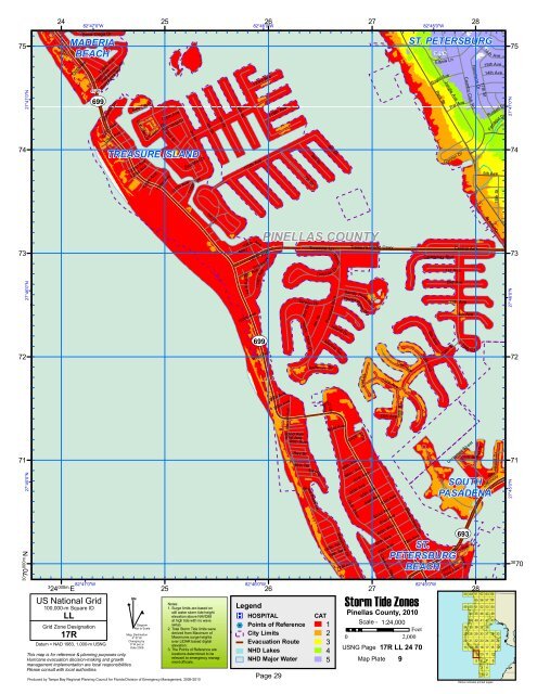
PINELLAS COUNTY<br />
2nd St<br />
Treasure Ln<br />
Dolph<br />
in<br />
Ramp<br />
Dr<br />
Treasure Island Cswy<br />
73 73<br />
27°46'0"N<br />
Tarpon<br />
Dr<br />
4th<br />
St<br />
Paradise<br />
Blvd<br />
Sandy Hook Rd<br />
HavenPoint<br />
Dr<br />
Causeway Blvd<br />
1st Ave<br />
Central Ave<br />
2nd Ave<br />
3rd Ave<br />
4th Ave<br />
27°46'0"N<br />
UV 699 UV 693<br />
Yacht Club<br />
Island Dr<br />
9th<br />
72 72<br />
101st Ave<br />
Dr<br />
Marina Ter<br />
Bellevue Dr<br />
11th<br />
Ave<br />
10th<br />
Ave<br />
Ave<br />
79th St<br />
79th<br />
C<br />
ir<br />
81st St<br />
12thAve<br />
71 71<br />
27°45'0"N<br />
30 70<br />
000m.N<br />
3<br />
24 000m. E<br />
82°47'0"W<br />
US National Grid<br />
100,000-m Square ID<br />
LL<br />
Grid Zone Designation<br />
17R<br />
Datum = NAD 1983, 1,000-m USNG<br />
This map is for reference & planning purposes only.<br />
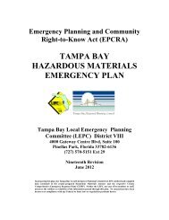
Hurricane evacuation decision-making and growth<br />
management implementation are local responsibilities.<br />
Please consult with local authorities.<br />
^<br />
GN<br />
#<br />
Diagram<br />
Not to Scale<br />
Mag. Declination<br />
4 0 31'W<br />
Changing by<br />
5' W per yr<br />
Date 2009<br />
25<br />
Produced by <strong>Tampa</strong> <strong>Bay</strong> <strong>Regional</strong> Planning Council for Florida Division of Emergency Management, 2009-2010<br />
82°46'0"W<br />
26<br />
99th Ave<br />
98th Ave<br />
Harrell Ave<br />
92nd Ave<br />
91st Ave<br />
90th Ave<br />
<strong>Bay</strong> Dr<br />
86th Ter<br />
Legend<br />
®v HOSPITAL<br />
%2 Points of Reference<br />
City Limits<br />
Evacuation Route<br />
NHD Lakes<br />
<strong>Bay</strong>Plz<br />
Blind Pass Dr<br />
93rd Ave<br />
<strong>Bay</strong>shore Dr<br />
80th Ter<br />
79th Ter<br />
89th Ave<br />
Gulf Blvd<br />
77th Ave<br />
Cir<br />
Captiva<br />
88th Ave<br />
87th Ave<br />
86th Ave<br />
85th Ave<br />
84th Ave<br />
27<br />
13th Ave<br />
83rd Ave<br />
82nd Ave<br />
81st Ave<br />
80th Way<br />
80th Ave<br />
79th Ave<br />
Coquina Way<br />
80th St<br />
Boca Ciega Dr<br />
ST.<br />
PETERSBURG<br />
BEACH<br />
78th Ave<br />
<strong>Storm</strong> <strong>Tide</strong> Zones<br />
Notes:<br />
1. Surge limits are based on<br />
still water storm tide height<br />
elevation above NAVD88<br />
at high tide with no wave<br />
setup.<br />
2. Total <strong>Storm</strong> <strong>Tide</strong> limits were<br />
derived from Maximum of<br />
Maximums surge heights<br />
over LIDAR based digital<br />
elevation.<br />
3. The Points of Reference are<br />
locations determined to be<br />
relevant to emergency manag-<br />
CAT<br />
1 Scale - 1:24,000<br />
Feet<br />
2<br />
0 2,000<br />
3<br />
USNG Page<br />
4<br />
17R LL 24 70<br />
NHD Major Water<br />
ment officials. 5 Map Plate 9<br />
Page 29<br />
<strong>Pinellas</strong> <strong>County</strong>, 2010<br />
82°45'0"W<br />
Unnamed Street<br />
75th<br />
Corey Ave<br />
73rd Ave<br />
Sun Isl a nd Dr<br />
SOUTH<br />
PASADENA<br />
Ave<br />
<strong>Bay</strong> St<br />
59<br />
49<br />
34<br />
27<br />
20<br />
13<br />
60<br />
50<br />
44<br />
39<br />
35<br />
28<br />
21<br />
14<br />
28<br />
61<br />
55<br />
51<br />
45<br />
40<br />
36<br />
29<br />
22<br />
15<br />
9<br />
5<br />
62<br />
56<br />
52<br />
46<br />
41<br />
37<br />
30<br />
23<br />
16<br />
10<br />
6<br />
3<br />
1<br />
Island Dr<br />
<strong>Bay</strong><br />
Driveway<br />
63<br />
57<br />
53<br />
47<br />
42<br />
38<br />
31<br />
24<br />
17<br />
11<br />
7<br />
4<br />
2<br />
64<br />
58<br />
54<br />
48<br />
43<br />
32<br />
25<br />
18<br />
12<br />
Yellow indicates printed pages<br />
8<br />
33<br />
26<br />
19<br />
27°45'0"N<br />
30<br />
70