Book 4: Pinellas County Storm Tide Atlas - Tampa Bay Regional ...
Book 4: Pinellas County Storm Tide Atlas - Tampa Bay Regional ...
Book 4: Pinellas County Storm Tide Atlas - Tampa Bay Regional ...

You also want an ePaper? Increase the reach of your titles
YUMPU automatically turns print PDFs into web optimized ePapers that Google loves.
141st St<br />
Cir<br />
6th Way<br />
85<br />
23.8 ft D<br />
85<br />
27°52'0"N<br />
27°51'0"N<br />
16<br />
82°52'0"W<br />
17<br />
1st Ave<br />
82°51'0"W<br />
1 st St<br />
18<br />
199th Ave<br />
198th Ave<br />
Shi<br />
pw atc hDr<br />
113th Ave<br />
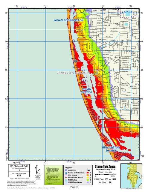
INDIAN ROCKS BEACH<br />
Oak<br />
Mary St<br />
ir<br />
C<br />
200th Ave<br />
Hardage St<br />
McMullen St<br />
Hammock St<br />
Sove<br />
Danielle Dr<br />
197th Ave<br />
<strong>Bay</strong> Pl<br />
Harbor<br />
Cathy Ln<br />
Regal<br />
Huston Ln<br />
reign Dr<br />
Way<br />
Crown Dr<br />
Dr<br />
195th Ave<br />
Shipwatch Trce<br />
Imperial Point<br />
5th Ave<br />
Dr<br />
Whispering Pines Dr<br />
Lowe Rd<br />
Pine Dr<br />
Sunset Dr<br />
Wildwood Dr<br />
Brewster Dr<br />
<strong>Bay</strong> Dr<br />
Majestic Dr<br />
3rd Ave<br />
2nd Ave<br />
Monarch Dr<br />
Seminole<br />
Trl<br />
Indi<br />
a<br />
n<br />
Key<br />
INDIAN<br />
SHORES<br />
Vista Ln<br />
2nd St<br />
Tr<br />
l<br />
Tara Cay Ct<br />
Hamlin Blvd<br />
191st Ave<br />
Vista Ln<br />
Apache Ave<br />
Sioux A v e<br />
Pinecrest St<br />
Mooring<br />
Cir<br />
cho ra g e<br />
An<br />
Al ejo<br />
Antigua Pl<br />
116th Ave<br />
Oliver St<br />
Iroquois<br />
Marina Way<br />
Ct<br />
144th St<br />
Unnamed Stre e<br />
Kandi Ct<br />
<strong>Bay</strong> Hills Dr<br />
H<br />
Tanglewood Dr<br />
Egret Ln<br />
illvi e w Dr<br />
Oakglen Dr<br />
D<br />
33 ft<br />
Yacht Club Blvd<br />
Dr<br />
102nd Ave<br />
Portside Dr<br />
Cu<br />
Ave<br />
Harb or Greens Way<br />
92nd Ter<br />
rrie Ln<br />
110th Ter<br />
Mark Dr<br />
Neptune Rd<br />
91st Ave<br />
144th Ln<br />
t<br />
Commodore Dr<br />
143rd Ln<br />
<strong>Bay</strong>haven Dr<br />
93rd Ave<br />
143rd St<br />
86th Pl<br />
Page Ave<br />
Chamberlain Ave<br />
142nd St<br />
142nd Way<br />
Thacher Ave<br />
88th<br />
86th Ter<br />
141st Ln<br />
111th<br />
Cook<br />
Ave<br />
82nd Ter<br />
<strong>Bay</strong>shore Dr<br />
Joel Ct<br />
Dr<br />
82nd Ave<br />
Ter<br />
Jennifer Ter<br />
89th Ave<br />
Hetrick<br />
Silhavy Dr<br />
85th Ave<br />
81st<br />
Cardinal Way<br />
86th Ave<br />
79th<br />
111th Ave<br />
104th Ave<br />
Lookout Way<br />
Leeward Dr<br />
94th Pl<br />
140th Ln<br />
90th Pl<br />
Ave<br />
140th St<br />
Av e<br />
140th Way<br />
<strong>County</strong> Road 233<br />
<strong>County</strong> Hwy 694<br />
Mis s<br />
139th Ln<br />
Bahama Ct<br />
80th Ave<br />
Carla Dr<br />
Joyce Dr<br />
Kimberly Dr<br />
Pinecrest Dr<br />
Meares Dr<br />
139th Way<br />
LARGO<br />
88th Ter<br />
D<br />
37.7 ft<br />
85th Ter<br />
84th Ter<br />
83rd Pl<br />
137th St<br />
105th Ter<br />
102nd Ter<br />
<strong>County</strong> Road 296<br />
Martinique Dr<br />
Dominica Dr<br />
Trinidad Dr<br />
Barbados Dr<br />
Antigua Dr<br />
Jamaica Dr<br />
Bermuda Dr<br />
Montego Dr<br />
138th<br />
St<br />
Yunker Dr<br />
ion Oaks Blvd<br />
94th Ave<br />
137th Ln<br />
Hammock Dr<br />
Antilles Dr<br />
87th Ave<br />
Pebble Dr<br />
Placid Dr<br />
San Rafael Dr<br />
84 84<br />
83 83<br />
PINELLAS COUNTY<br />
139th St<br />
138th St<br />
O a kwood L n<br />
Oak Forest Blvd<br />
Danielle Ct<br />
99<br />
97th Ter<br />
Claredon Rd<br />
thAve<br />
90thTer<br />
Heritage Dr<br />
Laurel Ct<br />
Del Prado Dr<br />
101st Ter<br />
100th<br />
96th<br />
Cor d<br />
Pl<br />
Forrest Dr<br />
3<br />
1<br />
Imperi a<br />
Serena<br />
ove Dr<br />
l Gr<br />
Regal Ln<br />
Ter<br />
Malaga Dr<br />
Andova Dr<br />
Dr<br />
100th Ave<br />
Ridgeland Dr<br />
82 82<br />
19<br />
82°50'0"W<br />
3<br />
20<br />
87th Pl<br />
ova Dr<br />
Keith Ave<br />
135th St<br />
Periwinkle Ave<br />
Bellewood Ave<br />
Alpine Ave<br />
Monalee Ave<br />
Willow Ct<br />
Oval Dr<br />
136th St<br />
27°52'0"N<br />
27°51'0"N<br />
UV 699 UV 699<br />
81 81<br />
Ramp<br />
77th Ave<br />
Harbor View Way<br />
76th Ter<br />
76th Ave<br />
75th Ave<br />
137th St<br />
74th Ave<br />
30 80<br />
000m.N 27°50'0"N<br />
3<br />
16 000m. E<br />
82°52'0"W<br />
US National Grid<br />
100,000-m Square ID<br />
LL<br />
Grid Zone Designation<br />
17R<br />
Datum = NAD 1983, 1,000-m USNG<br />
This map is for reference & planning purposes only.<br />
Hurricane evacuation decision-making and growth<br />
management implementation are local responsibilities.<br />
Please consult with local authorities.<br />
^<br />
GN<br />
#<br />
Diagram<br />
Not to Scale<br />
Mag. Declination<br />
4 0 31'W<br />
Changing by<br />
5' W per yr<br />
Date 2009<br />
17<br />
Produced by <strong>Tampa</strong> <strong>Bay</strong> <strong>Regional</strong> Planning Council for Florida Division of Emergency Management, 2009-2010<br />
82°51'0"W<br />
18<br />
Legend<br />
®v HOSPITAL<br />
%2 Points of Reference<br />
City Limits<br />
Evacuation Route<br />
NHD Lakes<br />
REDDINGTON<br />
SHORES<br />
19<br />
1st St<br />
181st Ave<br />
82°50'0"W<br />
<strong>Storm</strong> <strong>Tide</strong> Zones<br />
Notes:<br />
1. Surge limits are based on<br />
still water storm tide height<br />
elevation above NAVD88<br />
at high tide with no wave<br />
setup.<br />
2. Total <strong>Storm</strong> <strong>Tide</strong> limits were<br />
derived from Maximum of<br />
Maximums surge heights<br />
over LIDAR based digital<br />
elevation.<br />
3. The Points of Reference are<br />
locations determined to be<br />
relevant to emergency manag-<br />
CAT<br />
1 Scale - 1:24,000<br />
Feet<br />
2<br />
0 2,000<br />
3<br />
USNG Page<br />
4<br />
17R LL 16 80<br />
NHD Major Water<br />
ment officials. 5 Map Plate 20<br />
Page 40<br />
<strong>Pinellas</strong> <strong>County</strong>, 2010<br />
3rd St<br />
182nd<br />
Ave<br />
180th<br />
Ave<br />
59<br />
49<br />
34<br />
27<br />
20<br />
13<br />
3<br />
20<br />
60<br />
50<br />
44<br />
39<br />
35<br />
28<br />
21<br />
14<br />
61<br />
55<br />
51<br />
45<br />
40<br />
36<br />
29<br />
22<br />
15<br />
9<br />
5<br />
62<br />
56<br />
52<br />
46<br />
41<br />
37<br />
30<br />
23<br />
16<br />
10<br />
6<br />
3<br />
1<br />
63<br />
57<br />
53<br />
47<br />
42<br />
38<br />
31<br />
24<br />
17<br />
11<br />
7<br />
4<br />
2<br />
64<br />
58<br />
54<br />
48<br />
43<br />
32<br />
25<br />
18<br />
12<br />
Yellow indicates printed pages<br />
8<br />
33<br />
26<br />
19<br />
27°50'0"N<br />
30<br />
80