Book 4: Pinellas County Storm Tide Atlas - Tampa Bay Regional ...
Book 4: Pinellas County Storm Tide Atlas - Tampa Bay Regional ...
Book 4: Pinellas County Storm Tide Atlas - Tampa Bay Regional ...

Create successful ePaper yourself
Turn your PDF publications into a flip-book with our unique Google optimized e-Paper software.
Bamboo Ln<br />
Mia Cir<br />
Sophia Cir<br />
C<br />
Sunset<br />
Oaks Cir<br />
Barlow Ln<br />
Larchwood Dr<br />
Reservoir Dr<br />
Velma Dr<br />
121st<br />
118th<br />
Belle m ead e<br />
Railroad Ave<br />
Valen<br />
114th St<br />
Nassau<br />
Park St<br />
Canterbury Ln<br />
108th<br />
Kent Dr<br />
Driftwood Ln<br />
Buttonwood Ln<br />
Camelia Dr<br />
Royal Dr<br />
Alamanda Dr<br />
Jacaranda Dr<br />
139th St<br />
Eldon Dr<br />
138th Ln<br />
Mallory Dr<br />
138th St<br />
Sussex Ave<br />
Har<br />
126th Ave<br />
137th St<br />
Poinciana Ln<br />
ChurchCreek Pt<br />
137th Ln<br />
rn Ct<br />
Malve<br />
Hickory Ln<br />
Palm<br />
Palm Dr<br />
Dr<br />
Harbor<br />
View<br />
Lake Dr<br />
Ln<br />
Oakwood Dr<br />
b or Heights Dr<br />
136th Ln<br />
Oak St<br />
Cedar Ln<br />
Hill Dr<br />
Cove Dr<br />
Oak Manor<br />
Wilcox Rd<br />
136th St<br />
135th Ln<br />
Twig Ter<br />
Gulfview Dr<br />
Orangewood Ln<br />
135th St<br />
Sunset <strong>Bay</strong><br />
Blvd<br />
Brookside<br />
Ln<br />
134th S t<br />
Hibiscus Rd<br />
Crestwood Ln<br />
Shady Bluff Dr<br />
Avocado Dr<br />
Orchard Grove Ln<br />
Georgianna St<br />
Dr<br />
Live Oak Ln<br />
View Dr<br />
Hillsdale Ave<br />
Bluff<br />
Palmetto Ln<br />
Holly Ln<br />
Sunset Dr<br />
Harbor Bluff Dr<br />
Vonn Rd<br />
Lauren Dr<br />
21<br />
82°49'0"W<br />
43.1 ft D<br />
<strong>County</strong> Road 233<br />
Fountainhead Dr<br />
Gladys St<br />
130th St<br />
Clifton Ter<br />
Street<br />
114th Ave<br />
HilltopLn<br />
H oneys uckleRd<br />
131st St<br />
trus Ct<br />
Ci<br />
Mitchell Dr<br />
Sunset Blvd<br />
Vernon Ter<br />
Maiden Ln<br />
30th Ln<br />
124th Ave<br />
123rd<br />
Del Rio Dr<br />
Los Gatos Dr<br />
Los Altos Dr<br />
Knollwood Dr<br />
Ramp<br />
126th Ter<br />
Lentz Rd<br />
Valencia Blvd<br />
Dryer Ave<br />
Karen Ave<br />
Wilcox St<br />
1 29th St<br />
Martin St<br />
129th Ter<br />
128th Ave<br />
127th Ave<br />
A ve<br />
Fulton Way<br />
Renatta Dr<br />
21st Ter<br />
Jewell Rd<br />
<strong>Bay</strong>way Ave<br />
iveway<br />
r<br />
D<br />
Arbor<br />
Bluffs<br />
Ln<br />
Cypress St<br />
Pine St<br />
Leona Dr<br />
Temple Ln<br />
<strong>County</strong> Hwy 416<br />
Dr<br />
Overbrook Blvd<br />
Sunny Breeze Ave<br />
1<br />
Crescent Dr<br />
7th St<br />
2<br />
Lorraine Rd<br />
Cecil St<br />
21st Ave<br />
133rd<br />
21st Pl<br />
Apache Ln<br />
Ave<br />
Campbell Ln<br />
Mohoawk Ln<br />
N avajo Trl<br />
Laurel Ave<br />
Oak Ave<br />
12th<br />
ow Dr<br />
Will<br />
122nd Ave<br />
Southwind Dr<br />
India n Ave<br />
Duncan Dr<br />
25th St<br />
g<br />
Kil<br />
Ave<br />
ore Dr<br />
Elyria Ave<br />
10th Ave<br />
11th<br />
Shirley Ln<br />
DIX St<br />
A ve<br />
Wilson Ave<br />
Bonnie Gail St<br />
20th Ave<br />
134th Ave<br />
126th St<br />
Ash St<br />
125th St<br />
Jackson St<br />
Bel mar Dr<br />
Overbrook Ave<br />
Lanai Ave<br />
Dart Ave<br />
23rd St<br />
Overbrook St<br />
Coronet Dr<br />
13th Ave<br />
17th Ave<br />
22nd St<br />
19th Ave<br />
22 nd Way<br />
A dams Cir<br />
Cir<br />
Je<br />
Madison St<br />
14th Ave<br />
ffe<br />
rso n<br />
6th Pl<br />
7th Pl<br />
Britton St<br />
Nolan<br />
16th Ave<br />
Drive way<br />
Dr<br />
Ezelle Ave<br />
Stanton Ave<br />
Deborah Ave<br />
20th<br />
St<br />
Southgate Dr<br />
Mehlenbacher Rd<br />
Elizabeth St<br />
Kay Dr<br />
Neva Dr<br />
18th St<br />
Heritage Ln<br />
Northview Rd<br />
19th St<br />
120th Ln<br />
135th Av e<br />
16th St<br />
Edna Ave<br />
134th<br />
Adele Pl<br />
120th St<br />
Pl<br />
Shirley Pl<br />
Howard Pl<br />
St<br />
14th St<br />
Pine Vista Dr<br />
8th Ave<br />
Gooden Xing<br />
Palm Ave<br />
12th St<br />
Oak Village Dr<br />
Oak St<br />
Crosby St<br />
Ulmerton Rd<br />
132nd Ave<br />
130th Ave<br />
Murray Ave<br />
ir<br />
C<br />
13th Ln<br />
129th Ave<br />
117th St<br />
The <strong>Pinellas</strong> Trl<br />
11th St<br />
Walsingham Rd<br />
Dauphin Ave<br />
Pine Ave<br />
5th Ter<br />
Jackson Ave<br />
10th Ct<br />
11th Ct<br />
12th Ct<br />
14th Ct<br />
16th Ct<br />
Parkview Ln<br />
Jacks Ln<br />
116th Ln<br />
12th St<br />
The <strong>Pinellas</strong> Trl<br />
Arbor Ave<br />
11th St<br />
18th Ave<br />
3rd Ave<br />
2nd Ave<br />
9th Ave<br />
9th St<br />
8th St<br />
c<br />
9th St<br />
Palm Dr<br />
Madrid Dr<br />
iaDr<br />
124th Ter<br />
117th Ave<br />
116th Ave<br />
Bennett St<br />
113t h Way<br />
®v<br />
13th Ct<br />
125th Ter<br />
123rd Ter<br />
122nd Ter<br />
121st Ter<br />
118th Pl<br />
Ramp<br />
115th Ave<br />
114th Ter<br />
4th Ave<br />
Ridge Rd<br />
113th St<br />
Stremma Rd<br />
Alley<br />
6th St<br />
Court St<br />
5th Ave<br />
Cane Palm St<br />
131st Ave<br />
120th Te r<br />
Martinique<br />
5th St<br />
Woodrow Ave<br />
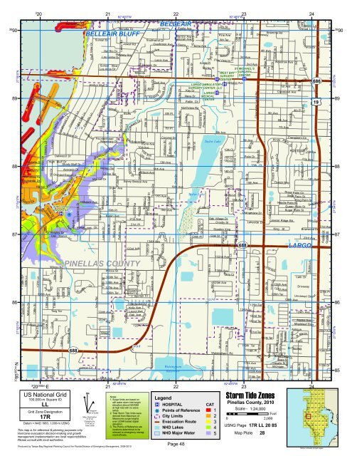
ST MICHAEL'S<br />
WEST BAY SURGERY<br />
SURGERY CENTER<br />
®v CENTER ®v<br />
®v<br />
UV 686<br />
LARGO AMBULATORY<br />
SURGERY CENTER, LLC<br />
LARGO ®v<br />
MEDICAL<br />
89 CENTER<br />
£¤ 19<br />
89<br />
D<br />
47.1 ft<br />
Taylor Lake<br />
88 88<br />
Taylor Lake<br />
SUN COAST<br />
HOSPITAL 13<br />
®v %2<br />
87 87<br />
UV 688<br />
LARGO<br />
D<br />
PINELLAS COUNTY<br />
63.7 ft<br />
86 D<br />
86<br />
54.9 ft<br />
D<br />
UV 688<br />
27°55'0"N<br />
27°54'0"N<br />
27°53'0"N<br />
H ar bor<br />
Cir<br />
3<br />
20<br />
Harbor<br />
Kimberly<br />
Imperi a<br />
3<br />
20 000m. E<br />
High Bluff Dr<br />
Hills Dr<br />
McKay Cre ek<br />
Croft<br />
ove Dr<br />
l Gr<br />
Dr<br />
Oval Dr<br />
ir<br />
Dr<br />
Pa<br />
r k<br />
i ng Lot<br />
B<br />
Pocah o ntas Dr<br />
o yette<br />
BELLEAIR BLUFF<br />
Cir<br />
Cimarron Cir<br />
Rosemary Dr<br />
Nellie St<br />
21<br />
Bel<br />
19th Pl<br />
Mary Sue St<br />
Forest Dr<br />
Hickory<br />
Fuller St<br />
McCrillus Rd<br />
128th Ln<br />
Dr<br />
128th St<br />
82°49'0"W<br />
<strong>Bay</strong><br />
Oakbrook<br />
D<br />
Mineola<br />
Maple St<br />
Dr<br />
Breeze Ter<br />
r<br />
Glenwood Dr<br />
Holly Ave<br />
Keat<br />
Trotter Rd<br />
Victory Ave<br />
24th St<br />
Dr<br />
ing<br />
Dr<br />
Overbrook<br />
Washington Dr<br />
Gatewood Dr<br />
22<br />
BELLEAIR<br />
30<br />
90<br />
30<br />
90<br />
30 85<br />
000m.N<br />
US National Grid<br />
100,000-m Square ID<br />
LL<br />
Grid Zone Designation<br />
17R<br />
Datum = NAD 1983, 1,000-m USNG<br />
This map is for reference & planning purposes only.<br />
Hurricane evacuation decision-making and growth<br />
management implementation are local responsibilities.<br />
Please consult with local authorities.<br />
^<br />
GN<br />
#<br />
Diagram<br />
Not to Scale<br />
Mag. Declination<br />
4 0 31'W<br />
Changing by<br />
5' W per yr<br />
Date 2009<br />
Produced by <strong>Tampa</strong> <strong>Bay</strong> <strong>Regional</strong> Planning Council for Florida Division of Emergency Management, 2009-2010<br />
21st St<br />
Sierra Cir<br />
Shirley Dr<br />
Westview Rd<br />
Walsingham<br />
Reservoir<br />
22<br />
Tropic Blvd<br />
Patlin Cir<br />
CircleDr<br />
St<br />
Eastview Rd<br />
Legend<br />
®v HOSPITAL<br />
%2 Points of Reference<br />
City Limits<br />
Evacuation Route<br />
NHD Lakes<br />
Pinecrest Dr<br />
5<br />
1<br />
TaylorLake Cir<br />
119th St<br />
th St<br />
7t h St<br />
Unnamed Street<br />
13th St<br />
15thCt<br />
K erry Ct<br />
Oak Ln<br />
82°48'0"W<br />
10th St<br />
116th St<br />
82°48'0"W<br />
15th Ave<br />
Orangeview Dr<br />
Driveway<br />
Lakeside Dr<br />
Ridge Rd<br />
119th Ter<br />
Clearwater Largo Rd<br />
Parking Lot<br />
Notes:<br />
1. Surge limits are based on<br />
still water storm tide height<br />
elevation above NAVD88<br />
at high tide with no wave<br />
setup.<br />
2. Total <strong>Storm</strong> <strong>Tide</strong> limits were<br />
derived from Maximum of<br />
Maximums surge heights<br />
over LIDAR based digital<br />
elevation.<br />
3. The Points of Reference are<br />
locations determined to be<br />
relevant to emergency manag-<br />
CAT<br />
1 Scale - 1:24,000<br />
Feet<br />
2<br />
0 2,000<br />
3<br />
USNG Page<br />
4<br />
17R LL 20 85<br />
NHD Major Water<br />
ment officials. 5 Map Plate 28<br />
Page 48<br />
23<br />
10th St<br />
115th St<br />
23<br />
112th St<br />
St<br />
Thatch Palm<br />
Sabal Palm Dr<br />
Windw ard Isle<br />
St Lucie<br />
1st Ave<br />
Cleveland Ave<br />
6th Ave<br />
6 St<br />
7th Ave<br />
Thatch Way<br />
128th Ave<br />
127th Ave<br />
126th Ter<br />
rd Isle<br />
Lee Wa<br />
Summit St<br />
Sago<br />
Needle Palm St<br />
Coastal Ridge Rd<br />
111th Ln<br />
<strong>Storm</strong> <strong>Tide</strong> Zones<br />
<strong>Pinellas</strong> <strong>County</strong>, 2010<br />
Pindo<br />
King St<br />
126th Ave<br />
Aruba<br />
Boca Ciega Dr<br />
State St<br />
Lasalle St<br />
Michigan<br />
4th St<br />
Palm<br />
Royal<br />
3rd St<br />
K St<br />
4th Pl<br />
1st<br />
<strong>Bay</strong>Dr<br />
Palm Cir<br />
Palm St<br />
Sugar Palm St<br />
Lark Dr<br />
124th Ave<br />
Missouri Ave<br />
14th Ave<br />
Sea Oats Dr<br />
20th Ter<br />
Briarwood Dr<br />
23rd Ave<br />
Mapleleaf Blvd<br />
Antiqua<br />
St Croix<br />
St Thomas<br />
109th St<br />
Re<br />
St<br />
2nd St<br />
10thAve<br />
11th Ave<br />
King Palm St<br />
Queen Palm St<br />
Ave<br />
Frangipani Cir<br />
St<br />
Palm Forest<br />
110th St<br />
Beec h wood Ln<br />
Com m<br />
St Martin<br />
dwood Ln<br />
Dr<br />
Robin Ln<br />
Driveway<br />
erce Dr<br />
Unnamed Stre et<br />
Alaska Ave<br />
59<br />
49<br />
34<br />
27<br />
20<br />
13<br />
Pl<br />
24<br />
108th St<br />
60<br />
50<br />
44<br />
39<br />
35<br />
28<br />
21<br />
14<br />
24<br />
61<br />
55<br />
51<br />
45<br />
40<br />
36<br />
29<br />
22<br />
15<br />
9<br />
5<br />
62<br />
56<br />
52<br />
46<br />
41<br />
37<br />
30<br />
23<br />
16<br />
10<br />
6<br />
3<br />
1<br />
21st Ave<br />
Azalea Dr<br />
127th Pl<br />
125t<br />
106th St<br />
122nd Ave<br />
119th<br />
Orchid St<br />
Poinsettia Dr<br />
h Ave<br />
105th St<br />
105th Ln<br />
Ave<br />
117th Dr<br />
63<br />
57<br />
53<br />
47<br />
42<br />
38<br />
31<br />
24<br />
17<br />
11<br />
7<br />
4<br />
2<br />
64<br />
58<br />
54<br />
48<br />
43<br />
32<br />
25<br />
18<br />
12<br />
Yellow indicates printed pages<br />
8<br />
33<br />
26<br />
19<br />
27°55'0"N<br />
27°54'0"N<br />
27°53'0"N<br />
85