Book 4: Pinellas County Storm Tide Atlas - Tampa Bay Regional ...
Book 4: Pinellas County Storm Tide Atlas - Tampa Bay Regional ...
Book 4: Pinellas County Storm Tide Atlas - Tampa Bay Regional ...

Create successful ePaper yourself
Turn your PDF publications into a flip-book with our unique Google optimized e-Paper software.
Corey Way<br />
The <strong>Pinellas</strong> Trl<br />
S<br />
Cir<br />
Driveway<br />
Brookwood Ct<br />
£¤ 19<br />
75 75<br />
D<br />
22.6 ft<br />
D<br />
UV 693<br />
74 74<br />
ST. PETERSBURG<br />
15.4 ft D<br />
Pasadena Lake<br />
Disston, Lake<br />
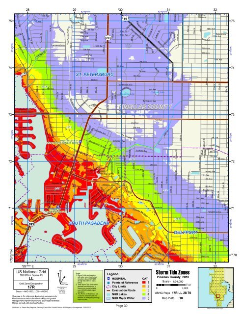
PINELLAS COUNTY<br />
73 73<br />
11.6 ft<br />
D<br />
HEALTHSOUTH ST.<br />
PETERSBURG SURGERY CENTE ®v<br />
72<br />
18.6 ft<br />
D<br />
72<br />
4.4 ft<br />
D<br />
16.7 ft<br />
D<br />
71 ®v<br />
PALMS OF<br />
71<br />
PASADENA HOSPITAL<br />
13.6 ft<br />
D<br />
UV 693 SOUTH PASADENA<br />
27°47'0"N<br />
27°46'0"N<br />
27°45'0"N<br />
30 70<br />
000m.N<br />
80th St<br />
Follow Thru Rd<br />
Bogie Ave<br />
Garden Dr<br />
79th St<br />
9th<br />
Jungle Ave<br />
Sailboat<br />
Ramp<br />
Causeway Blvd<br />
Corey<br />
2nd Ave<br />
Ave<br />
Unnamed Street<br />
75th<br />
Key Blvd<br />
Ave<br />
73rd Ave<br />
Country Club<br />
79th<br />
3rd Ave<br />
Ave<br />
<strong>Bay</strong> St<br />
Rd<br />
Robinson Dr<br />
C<br />
28<br />
ir<br />
77th St<br />
3<br />
28 000m. E<br />
17th<br />
<strong>Bay</strong><br />
76th St<br />
Island Dr<br />
Driveway<br />
Ave<br />
Russell Dr<br />
19th Ave<br />
Dr<br />
Farragut<br />
75th St<br />
US National Grid<br />
100,000-m Square ID<br />
LL<br />
Grid Zone Designation<br />
17R<br />
Sunset Dr<br />
Datum = NAD 1983, 1,000-m USNG<br />
74th St<br />
4th Ave<br />
Park<br />
Villa Grande Ave<br />
Durling Dr<br />
St<br />
1st Ave<br />
Flagler St<br />
72nd St<br />
Majestic Way<br />
14th Ave<br />
Mathews Rd<br />
Lynnwood Ave<br />
des Rois<br />
Island Dr<br />
73rd St<br />
des Reines<br />
Bignonia Way<br />
Liebman Ln<br />
Shore<br />
This map is for reference & planning purposes only.<br />
Hurricane evacuation decision-making and growth<br />
management implementation are local responsibilities.<br />
Please consult with local authorities.<br />
^<br />
71th St<br />
Travelers<br />
Grande Vista Way<br />
GN<br />
des Chateaux<br />
#<br />
Parking Lot<br />
Harbor Pl<br />
Dr<br />
Diagram<br />
Not to Scale<br />
Mag. Declination<br />
4 0 31'W<br />
Changing by<br />
5' W per yr<br />
Date 2009<br />
ton esthro w<br />
70th St<br />
71st St<br />
29<br />
2 0<br />
Way<br />
16th Pl<br />
69th St<br />
67th Ln<br />
Orange Ave<br />
Date Palm Ave<br />
Cove Dr<br />
29<br />
th Ave<br />
82°44'0"W<br />
16th Ave<br />
15th Ave<br />
14th Ave<br />
16th Ter<br />
12th Ave<br />
82°44'0"W<br />
11th Ave<br />
10th Ave<br />
68th St<br />
Merydith Way<br />
Oleander Way<br />
Cir<br />
P ark<br />
Crosswinds<br />
D r<br />
5th Ave<br />
<strong>Pinellas</strong> Way<br />
Poinsettia Ave<br />
Bougainvilla Ave<br />
Sea Gull Dr<br />
C<br />
12th Ter<br />
67th St<br />
Pasadena<br />
Hibi scus Ave<br />
Cardinal Dr<br />
10t h<br />
Robin Rd<br />
Blue Heron Dr<br />
Produced by <strong>Tampa</strong> <strong>Bay</strong> <strong>Regional</strong> Planning Council for Florida Division of Emergency Management, 2009-2010<br />
t<br />
66th Ln<br />
Rosati Ln<br />
Marion Dr<br />
Mockingbird Way<br />
13th Ave<br />
La Plaza Ave<br />
66th St<br />
D olphin Blvd<br />
Bamboo Dr<br />
Brookwood Dr<br />
Avenue<br />
65th Way<br />
Palm Ln<br />
Ter<br />
Renaldo Way<br />
Dixie Ln<br />
65th St<br />
Sea Gull Ln<br />
Royal Palm Dr<br />
Sail<br />
fish Rd<br />
Pompano Pl<br />
3<br />
30<br />
17th Pl<br />
8th Ave<br />
Dartmouth Ave<br />
Central Ave<br />
Emerson Ave<br />
Heron St<br />
17th Ter<br />
Eadon Ln<br />
Alley<br />
The <strong>Pinellas</strong> Trl<br />
Plum St<br />
Peli c an<br />
64th St<br />
V<br />
1 8th Ave<br />
Lakeshore Dr<br />
Dr<br />
3<br />
30<br />
ista Ver de<br />
63rd Way<br />
63rd St<br />
Dr<br />
Brad shaw<br />
Devonshire Dr<br />
6th Ave<br />
2nd Ave<br />
3rd Ave<br />
63rd St<br />
Pasad ena<br />
Ave<br />
17th<br />
Oxford St<br />
9th Ave<br />
7th Ave<br />
10th Ave<br />
Kipps<br />
Ln<br />
62nd St<br />
Colo<br />
Kipps C olony Dr<br />
Legend<br />
®v HOSPITAL<br />
%2 Points of Reference<br />
City Limits<br />
Evacuation Route<br />
NHD Lakes<br />
Seabreeze<br />
62nd St<br />
Fairfield Ave<br />
Fairway <strong>Bay</strong> Blv d<br />
PointBlvd<br />
Dr<br />
Tyrone Blvd<br />
Tyrone Ct<br />
n y Ct<br />
Norfolk St<br />
4th Ave<br />
Burlington Ave<br />
13th Ave<br />
Gulfport Blvd<br />
Ramp<br />
9th Ave<br />
61st St<br />
60th Way<br />
Essex Dr<br />
1st Ave<br />
15th Ave<br />
Luana Ln<br />
<strong>Bay</strong> Dr<br />
Suffolk St<br />
Hull St<br />
Pelican<br />
60th St<br />
<strong>Bay</strong> Plz<br />
Skimm er Point Blvd<br />
82°43'0"W<br />
82°43'0"W<br />
Rd<br />
Winchester<br />
St<br />
60th<br />
59th Ln<br />
Gray St<br />
Premier Dr<br />
Canterbury Rd<br />
59th St<br />
59th Way<br />
Folsom St<br />
Freemont St<br />
59th St<br />
25th Ave<br />
26th Ave<br />
58th St<br />
57th St<br />
57th St<br />
Driveway<br />
56th St<br />
56th St<br />
GULFPORT<br />
Notes:<br />
1. Surge limits are based on<br />
still water storm tide height<br />
elevation above NAVD88<br />
at high tide with no wave<br />
setup.<br />
2. Total <strong>Storm</strong> <strong>Tide</strong> limits were<br />
derived from Maximum of<br />
Maximums surge heights<br />
over LIDAR based digital<br />
elevation.<br />
3. The Points of Reference are<br />
locations determined to be<br />
relevant to emergency manag-<br />
CAT<br />
1 Scale - 1:24,000<br />
Feet<br />
2<br />
0 2,000<br />
3<br />
USNG Page<br />
4<br />
17R LL 28 70<br />
NHD Major Water<br />
ment officials. 5 Map Plate 10<br />
Page 30<br />
31<br />
31<br />
<strong>Storm</strong> <strong>Tide</strong> Zones<br />
<strong>Pinellas</strong> <strong>County</strong>, 2010<br />
23rd Ave<br />
20th Ave<br />
19th Ave<br />
55th St<br />
Unnamed Street<br />
55th St<br />
54th Ln<br />
Braddock St<br />
16th Ave<br />
18th Ave<br />
19th Ave<br />
20th Ave<br />
21st Ave<br />
Beach Blvd<br />
14th<br />
54th Way<br />
54th St<br />
11th Ave<br />
Newton Ave<br />
54th St<br />
6th<br />
17th Ave<br />
27th Ave<br />
16th Ave<br />
Ave<br />
12th Ave<br />
11th Ave<br />
Tangerine Ave<br />
D<br />
Pl<br />
12th Ave<br />
14th Ave<br />
53rd St<br />
10th Ave<br />
53rd St<br />
5th Ave<br />
6th<br />
7th Ave<br />
Jersey Ave<br />
Ohio Ct<br />
32<br />
6th Ter<br />
59<br />
49<br />
34<br />
27<br />
20<br />
13<br />
60<br />
50<br />
44<br />
39<br />
35<br />
28<br />
21<br />
14<br />
Oxford Ave<br />
15th Ave<br />
32<br />
61<br />
55<br />
51<br />
45<br />
40<br />
36<br />
29<br />
22<br />
15<br />
5<br />
Ave<br />
9<br />
52nd St<br />
8th Ave<br />
52nd St<br />
York St<br />
51st Way<br />
51st St<br />
Preston Ave<br />
62<br />
56<br />
52<br />
46<br />
41<br />
37<br />
30<br />
23<br />
16<br />
10<br />
6<br />
3<br />
1<br />
51st St<br />
24th Ave<br />
63<br />
57<br />
53<br />
47<br />
42<br />
38<br />
31<br />
24<br />
17<br />
11<br />
7<br />
4<br />
2<br />
64<br />
58<br />
54<br />
48<br />
43<br />
32<br />
25<br />
18<br />
12<br />
Yellow indicates printed pages<br />
8<br />
33<br />
26<br />
19<br />
27°47'0"N<br />
27°46'0"N<br />
27°45'0"N<br />
30<br />
70