Book 4: Pinellas County Storm Tide Atlas - Tampa Bay Regional ...
Book 4: Pinellas County Storm Tide Atlas - Tampa Bay Regional ...
Book 4: Pinellas County Storm Tide Atlas - Tampa Bay Regional ...

You also want an ePaper? Increase the reach of your titles
YUMPU automatically turns print PDFs into web optimized ePapers that Google loves.
North St<br />
Florida Ave<br />
Count Ct<br />
Stonefence Way<br />
Cavemill Way<br />
Lynnlea Ln<br />
Village Dr<br />
Gulf Oaks Dr<br />
his p ering Way<br />
Tradewinds Dr<br />
Robin Trl<br />
Carolina Ave<br />
24<br />
25<br />
26<br />
27<br />
28<br />
82°47'0"W<br />
82°46'0"W<br />
82°45'0"W<br />
D<br />
13.4 ft<br />
15 15<br />
28°9'0"N<br />
28°8'0"N<br />
Unna me d<br />
eet<br />
Str<br />
W<br />
Bea c h Dr<br />
indrush<strong>Bay</strong> Dr<br />
Gulf Beach Blvd<br />
Mexico Ave<br />
Tafford St<br />
D 12.4 ft<br />
Drivewa y<br />
Ventnor Ave<br />
Misty Ln<br />
Harmony Ln<br />
TarponPt<br />
Forde Ave<br />
Anclote Dr<br />
Poinsettia Ave<br />
Oleander Dr<br />
Tallahassee Dr<br />
Goshen Rd<br />
Mariner Way<br />
D<br />
16 ft<br />
Peninsula Rd<br />
Tiara Ln<br />
Ironworks Ln<br />
Gainesway Dr<br />
Cottage Pl<br />
Glades Ave<br />
Lily Ct<br />
<strong>County</strong> Road 80<br />
Semin ole<br />
Gulf Rd<br />
Crossbow Ln<br />
Eunice Dr<br />
Coppertree Dr<br />
<strong>Bay</strong>shore<br />
12 £¤ 19<br />
12<br />
28°7'0"N<br />
Mandalay Dr<br />
Shore Dr<br />
Coburn Dr<br />
Gul<br />
f<br />
Front Dr<br />
Garden Ave<br />
Arthurs Ct<br />
Connecticut Rd<br />
Rosetree Ln<br />
Jamaica Way<br />
easc<br />
S<br />
ape<br />
Mariner<br />
Cir<br />
Dr<br />
Me rlins Ct<br />
Driftwood Pl<br />
Morningside Dr<br />
Toddsmill Trce<br />
Oak Bluff Dr<br />
W<br />
Blvd<br />
Palm<br />
Gulfview Woods Ln<br />
Timberlane Dr<br />
Driftwood Dr<br />
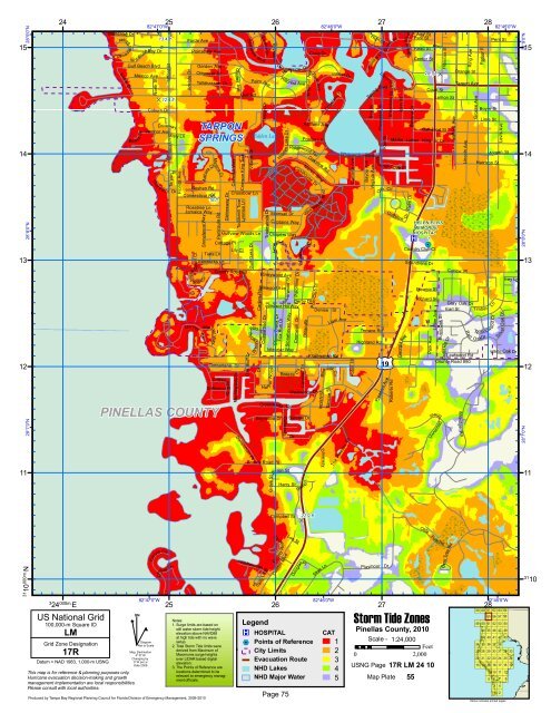
PINELLAS COUNTY<br />
TARPON<br />
SPRINGS<br />
Crimson King Trce<br />
Danenman Pt<br />
Ave<br />
Tarpon Dr<br />
Dr<br />
Hidden Lake<br />
Carlton Rd<br />
Dr<br />
Crosswinds<br />
<strong>County</strong> Road 78<br />
Grove St<br />
Mainsail Dr<br />
Greywood Ave<br />
Fox Run Dr<br />
Idlebriar Way<br />
<strong>Bay</strong>wood Dr<br />
Silv erwood St<br />
Silkwood Ave<br />
Riversid e D<br />
Hillcrest Ave<br />
Captains Way<br />
Clippers Way<br />
Windsor Hill Way<br />
or Woods<br />
Har b<br />
Stone Creek Dr<br />
LancerLn<br />
Lake Dr<br />
Hidden<br />
Stonehaven Way<br />
Breeze<br />
Gulfwinds<br />
Dr<br />
Byron St<br />
Palomino Dr<br />
Cromwell Dr<br />
Harry St<br />
Cardinal Trl<br />
r<br />
Derby Dr<br />
Westwinds<br />
Meres Blvd<br />
Ramp<br />
Ashland Ave<br />
Ridgewood Ter<br />
Beaver<br />
Kreamer Ave<br />
Westwin ds<br />
Dr<br />
Sunrise Dr<br />
Dr<br />
Craig Dr<br />
Poulos Ln<br />
Lighthouse Dr<br />
ir<br />
C<br />
BrilandSt<br />
Park Ave<br />
Oakview Rd<br />
Polo Club Dr<br />
Klosterman Rd<br />
Dr<br />
Blvd<br />
Innisfil St<br />
Driveway<br />
St<br />
Simcoe<br />
Inness Dr<br />
Cleveland Pl<br />
Denise St<br />
Liam Ave<br />
CirBlue Jay<br />
The <strong>Pinellas</strong> Trl<br />
<strong>Bay</strong>ou Ave<br />
High St<br />
Virginia Ave<br />
Central Ct<br />
Mo o<br />
r<br />
Terrace Rd<br />
Highland Rd<br />
LibraryCt<br />
Spring Blvd<br />
<strong>Bay</strong> St<br />
Whitcomb Blvd<br />
Pineapple St<br />
Kiwi St<br />
Canal St<br />
Shaddock St<br />
®v<br />
25.1 ft D<br />
%2<br />
Hibiscus St<br />
Martin Luther King Jr Dr<br />
14 14<br />
ingsCove Dr<br />
Oak Cir<br />
Pleasant Ave<br />
Roberts Rd<br />
Bath St<br />
Golfview<br />
Blvd<br />
Grand<br />
Palm Dr<br />
Dr<br />
Country Club Ct<br />
Georgia Ave<br />
Banana St<br />
Ada St<br />
Park St<br />
Read St<br />
Center St<br />
St Andrens Dr<br />
Eleanor St<br />
Richard St<br />
Park Ave<br />
Alley<br />
Court St<br />
Lemon St<br />
Oakwood St<br />
HELEN ELLIS<br />
MEMORIAL<br />
HOSPITAL<br />
1<br />
13 13<br />
Lillian Ave<br />
Burnt Oak St<br />
Earl St<br />
Orange St<br />
Tarpon Ave<br />
Curlew Pl<br />
Red<br />
<strong>County</strong> Road 880<br />
Stre et<br />
Unnamed<br />
Crest Hill Dr<br />
Safford Ave<br />
Lincoln Ave<br />
Ring Ave<br />
Gray Oak Dr<br />
Leafwood Rd<br />
Millridge<br />
Rd<br />
Grosse Ave<br />
Parker Pl<br />
Boyer St<br />
O akDr<br />
Lime St<br />
Harrison St<br />
Timber<br />
Rol<br />
Ln<br />
lingw ood Ct<br />
Pent St<br />
Morgan St<br />
Dr<br />
Silv er Oak<br />
Levis Ave<br />
Ivey Ln<br />
White Oak Dr<br />
11 11<br />
28°9'0"N<br />
28°8'0"N<br />
28°7'0"N<br />
Campbell St<br />
22.9 ft<br />
D<br />
Olde<br />
31 10<br />
000m.N<br />
3<br />
24 000m. E<br />
US National Grid<br />
100,000-m Square ID<br />
LM<br />
Grid Zone Designation<br />
17R<br />
Datum = NAD 1983, 1,000-m USNG<br />
This map is for reference & planning purposes only.<br />
Hurricane evacuation decision-making and growth<br />
management implementation are local responsibilities.<br />
Please consult with local authorities.<br />
^<br />
GN<br />
Carlyle Cir<br />
Ca<br />
82°47'0"W<br />
#<br />
Diagram<br />
Not to Scale<br />
Mag. Declination<br />
4 0 31'W<br />
Changing by<br />
5' W per yr<br />
Date 2009<br />
rly<br />
le Dr<br />
25<br />
Produced by <strong>Tampa</strong> <strong>Bay</strong> <strong>Regional</strong> Planning Council for Florida Division of Emergency Management, 2009-2010<br />
Hillsborough St<br />
S<br />
Ln<br />
h ady<br />
<strong>County</strong> R o ad 43<br />
26<br />
Desoto Blvd<br />
Lee St<br />
DouglasPl<br />
Legend<br />
®v HOSPITAL<br />
%2 Points of Reference<br />
City Limits<br />
Evacuation Route<br />
NHD Lakes<br />
Skye<br />
Ln<br />
82°46'0"W<br />
Playmoor Dr<br />
Notes:<br />
1. Surge limits are based on<br />
still water storm tide height<br />
elevation above NAVD88<br />
at high tide with no wave<br />
setup.<br />
2. Total <strong>Storm</strong> <strong>Tide</strong> limits were<br />
derived from Maximum of<br />
Maximums surge heights<br />
over LIDAR based digital<br />
elevation.<br />
3. The Points of Reference are<br />
locations determined to be<br />
relevant to emergency manag-<br />
CAT<br />
1 Scale - 1:24,000<br />
Feet<br />
2<br />
0 2,000<br />
3<br />
USNG Page<br />
4<br />
17R LM 24 10<br />
NHD Major Water<br />
ment officials. 5 Map Plate 55<br />
Page 75<br />
27<br />
<strong>Storm</strong> <strong>Tide</strong> Zones<br />
<strong>Pinellas</strong> <strong>County</strong>, 2010<br />
Post Rd<br />
Bent Tree Rd<br />
82°45'0"W<br />
28<br />
59 60 61 62 63 64<br />
55 56 57 58<br />
49 50 51 52 53 54<br />
44 45 46 47 48<br />
39 40 41 42 43<br />
34 35 36 37 38<br />
27 28 29 30 31 32 33<br />
20 21 22 23 24 25 26<br />
13 14 15 16 17 18 19<br />
9 10 11 12<br />
5 6 7 8<br />
3 4<br />
1 2<br />
Yellow indicates printed pages<br />
31<br />
10