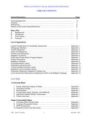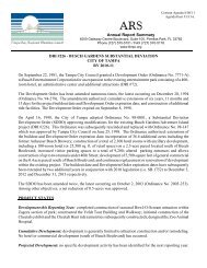
Book 4: Pinellas County Storm Tide Atlas - Tampa Bay Regional ...
Book 4: Pinellas County Storm Tide Atlas - Tampa Bay Regional ...
Book 4: Pinellas County Storm Tide Atlas - Tampa Bay Regional ...

You also want an ePaper? Increase the reach of your titles
YUMPU automatically turns print PDFs into web optimized ePapers that Google loves.
Rd<br />
27.8 ft<br />
D<br />
31 31<br />
20 20<br />
28°11'0"N<br />
Orsi Ct<br />
Pe<br />
Mitchell Blvd<br />
rs eaCt<br />
St<br />
Hawbuc k<br />
Tawnybe rry<br />
Ct<br />
Flatwood Ct<br />
Arde nwood Ct<br />
Fenhollo way Ct<br />
T rl<br />
Lov as<br />
36<br />
Linebrook Dr<br />
Wellness Ln<br />
Photonics Dr<br />
WavyedgeCt<br />
Stipule Ct<br />
<strong>County</strong> Hwy 996<br />
Kish Blvd<br />
Torchwood Dr<br />
82°40'0"W<br />
Ramp<br />
Little Rd<br />
<strong>County</strong> Hwy 1<br />
Robert Trent Jones<br />
Pkwy<br />
Bel Meadow Way<br />
Trinity Blvd<br />
Callaway Dr<br />
Chittamwood Blvd<br />
Gallberry Ct<br />
Lenton Rose Ct<br />
37<br />
Kaffir Lily Ct<br />
Alcott Way<br />
V<br />
Swamp Rose Ln<br />
African<br />
Impatiens Ct<br />
31.2 ft<br />
D 31.2 ft<br />
31.2 ft<br />
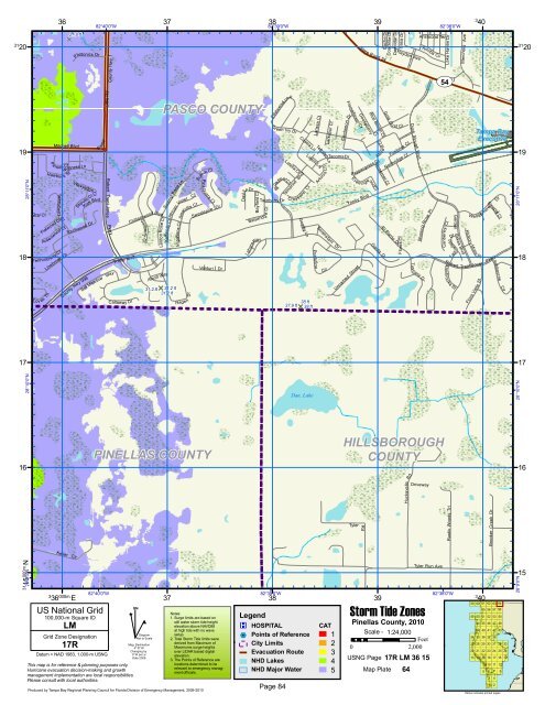
PASCO COUNTY<br />
iolet<br />
Amaryllis Ct<br />
Dr<br />
Hage n<br />
Ct<br />
Sumac Ct<br />
Pink G uara Ct<br />
Sweetspire Dr<br />
Venturi Dr<br />
Daylily Dr<br />
<strong>Bay</strong>field Ct<br />
Balsarid g<br />
LaharaWay<br />
EdelweissLoop<br />
Gr een Ivy Dr<br />
Broadleaf Ct<br />
Twinberry Dr<br />
e Ct<br />
38<br />
82°39'0"W<br />
Latelia Ct<br />
Tamarind Blvd<br />
Cassia Ln<br />
C ros svine Ct<br />
Goalby Ln<br />
38 ft<br />
37.9 ft<br />
D 38 ft<br />
Larissa Ct<br />
Linton Ln<br />
Pontofino<br />
Larkspur Ct<br />
Terralyn Ln<br />
Ln<br />
Arturus<br />
Sorenstam Dr<br />
Cir<br />
TacomaDr<br />
Flameflower Ct<br />
Cardamon Dr<br />
Peppergrass Ct<br />
Even<br />
Trinity Blvd<br />
Unnamed Street<br />
Gooseberry<br />
ingwoodCt<br />
39<br />
Blue Beech Ct<br />
Ct<br />
st Ct<br />
Cache Dr<br />
State Road 54<br />
Alec o<br />
Roseroot Ct<br />
Garda Dr<br />
Coachlite Dr<br />
Gold D u<br />
Damodar Dr<br />
st<br />
Casa Dr<br />
Hayden Ave<br />
Ct<br />
Firebrick Ct<br />
Northridge Ct<br />
El Pardo Dr<br />
Flores Ct<br />
Duck Slough Blvd<br />
Tus c any Dr<br />
Aristocrat Ter<br />
Arroba<br />
Morning Rose Pl<br />
Cv<br />
82°38'0"W<br />
Lake Haven Dr<br />
UV 54<br />
Canberley Ct<br />
Garden<br />
o wfield Dr<br />
Fall<br />
Robert<br />
Al anbrook e St<br />
Lakes Blvd<br />
Merchant Ave<br />
W edgemere Dr<br />
Hickory Moss<br />
Pl<br />
Trent Jones<br />
St<br />
Flora Vista<br />
3<br />
40<br />
<strong>Tampa</strong> <strong>Bay</strong><br />
Executive<br />
19 19<br />
18 18<br />
Steeple Ct<br />
Pkwy<br />
Ashbourne<br />
Cir<br />
28°11'0"N<br />
17 17<br />
28°10'0"N<br />
Dan, Lake<br />
28°10'0"N<br />
PINELLAS COUNTY<br />
HILLSBOROUGH<br />
COUNTY<br />
16 16<br />
Rd<br />
Huckavalle<br />
Driveway<br />
Tyler<br />
Rustic Woods Trl<br />
Brooker Creek Dr<br />
Keller Cir<br />
31<br />
28°9'0"N 15<br />
000m.N<br />
3<br />
36 000m. E<br />
82°40'0"W<br />
US National Grid<br />
100,000-m Square ID<br />
LM<br />
Grid Zone Designation<br />
17R<br />
Datum = NAD 1983, 1,000-m USNG<br />
This map is for reference & planning purposes only.<br />
Hurricane evacuation decision-making and growth<br />
management implementation are local responsibilities.<br />
Please consult with local authorities.<br />
^<br />
GN<br />
#<br />
Diagram<br />
Not to Scale<br />
Mag. Declination<br />
4 0 31'W<br />
Changing by<br />
5' W per yr<br />
Date 2009<br />
Produced by <strong>Tampa</strong> <strong>Bay</strong> <strong>Regional</strong> Planning Council for Florida Division of Emergency Management, 2009-2010<br />
37<br />
82°39'0"W<br />
38<br />
Legend<br />
®v HOSPITAL<br />
%2 Points of Reference<br />
City Limits<br />
Evacuation Route<br />
NHD Lakes<br />
39<br />
<strong>Storm</strong> <strong>Tide</strong> Zones<br />
<strong>Pinellas</strong> <strong>County</strong>, 2010<br />
Tyler Run Ave<br />
Notes:<br />
1. Surge limits are based on<br />
still water storm tide height<br />
elevation above NAVD88<br />
at high tide with no wave<br />
setup.<br />
2. Total <strong>Storm</strong> <strong>Tide</strong> limits were<br />
derived from Maximum of<br />
Maximums surge heights<br />
over LIDAR based digital<br />
elevation.<br />
3. The Points of Reference are<br />
locations determined to be<br />
relevant to emergency manag-<br />
CAT<br />
1 Scale - 1:24,000<br />
Feet<br />
2<br />
0 2,000<br />
3<br />
USNG Page<br />
4<br />
17R LM 36 15<br />
NHD Major Water<br />
ment officials. 5 Map Plate 64<br />
Page 84<br />
82°38'0"W<br />
3<br />
40<br />
59 60 61 62 63 64<br />
55 56 57 58<br />
49 50 51 52 53 54<br />
44 45 46 47 48<br />
39 40 41 42 43<br />
34 35 36 37 38<br />
27 28 29 30 31 32 33<br />
20 21 22 23 24 25 26<br />
13 14 15 16 17 18 19<br />
9 10 11 12<br />
5 6 7 8<br />
3 4<br />
1 2<br />
Yellow indicates printed pages<br />
28°9'0"N<br />
15