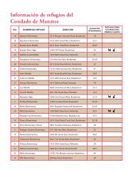
Book 4: Pinellas County Storm Tide Atlas - Tampa Bay Regional ...
Book 4: Pinellas County Storm Tide Atlas - Tampa Bay Regional ...
Book 4: Pinellas County Storm Tide Atlas - Tampa Bay Regional ...

Create successful ePaper yourself
Turn your PDF publications into a flip-book with our unique Google optimized e-Paper software.
76th St<br />
74th St<br />
71st Way<br />
Belcher Rd<br />
l Ave<br />
64th Ln<br />
9<br />
62nd Way<br />
61st Ln<br />
59th St<br />
52nd Ln<br />
1<br />
52nd St<br />
52nd St<br />
82°45'0"W<br />
£¤ 19<br />
85<br />
UV 693<br />
85<br />
D<br />
17.5 ft<br />
WINDMOOR<br />
HEALTHCARE<br />
7<br />
%2 ®v OF CLEARWATER<br />
®v<br />
TAMPA BAY<br />
REGIONAL<br />
D<br />
16 ft<br />
SURGERY CENTER<br />
84 84<br />
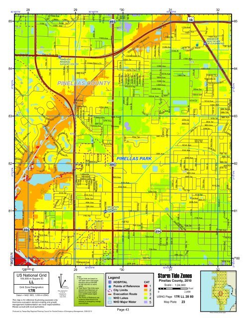
PINELLAS COUNTY<br />
11.2 ft<br />
D<br />
15 ft<br />
83<br />
D<br />
83<br />
D 15 ft 16 ft D<br />
82<br />
PINELLAS PARK<br />
UV 693 82<br />
27°52'0"N<br />
27°51'0"N<br />
Blvd<br />
or<br />
Merrim o<br />
112th Cir<br />
81 ®v CENTER<br />
81<br />
30<br />
27°50'0"N 80<br />
000m.N<br />
Driveway<br />
iveway<br />
r<br />
D<br />
Bryan Dairy Rd<br />
Bardmoor<br />
<strong>Bay</strong>ou Dr<br />
Pl<br />
Harwood Rd<br />
Ivywood R d<br />
Idlewild Ln<br />
Unnamed Street<br />
28<br />
Oliver Rd<br />
Silverthorn Rd<br />
<strong>County</strong> Road 296<br />
UV 694 UV 694<br />
79th St<br />
78th St<br />
3<br />
28 000m. E<br />
Belcher Rd<br />
75th Ave<br />
77th St<br />
70th Ave<br />
76th Ct<br />
Aralia Way<br />
<strong>Bay</strong>ou Club<br />
Ln<br />
Hu nter<br />
75th Way<br />
72nd Ave<br />
76th<br />
Foxta<br />
Water Silk<br />
71st Ave<br />
US National Grid<br />
100,000-m Square ID<br />
LL<br />
Grid Zone Designation<br />
17R<br />
St<br />
il R d<br />
Datum = NAD 1983, 1,000-m USNG<br />
Dr<br />
75th St<br />
75th St<br />
119th Ave<br />
118thDr<br />
Blvd<br />
118th Ave<br />
74th St<br />
Sago Point Dr<br />
Waterash Ln<br />
Laurel Dr<br />
73rd Ct<br />
10 ft D<br />
73rd Wa y<br />
118th Ter<br />
Caya Costa<br />
Sandwater<br />
Bryce<br />
81st Ter<br />
73rd St<br />
Trl<br />
118thCir<br />
72nd Way<br />
Sawgrass Point Dr<br />
Circle Creek<br />
This map is for reference & planning purposes only.<br />
Hurricane evacuation decision-making and growth<br />
management implementation are local responsibilities.<br />
Please consult with local authorities.<br />
^<br />
GN<br />
72nd Way<br />
Dr<br />
#<br />
72nd St<br />
Pt<br />
72nd St<br />
Diagram<br />
Not to Scale<br />
Mag. Declination<br />
4 0 31'W<br />
Changing by<br />
5' W per yr<br />
Date 2009<br />
71st Cir<br />
71st St<br />
29<br />
70th<br />
St<br />
Tulane Ave<br />
Lafayette St<br />
Deauville<br />
Jeffrey<br />
D 11 ft<br />
Saratoga St<br />
Phillip<br />
69th Way<br />
108th Ave<br />
Girod Ave<br />
Canal St<br />
29<br />
<strong>Bay</strong>ou Way<br />
Liberty St<br />
Endeavor Way<br />
Basin St<br />
Esplanade Ave<br />
70th St<br />
69th St<br />
Lafayette<br />
Versailles<br />
Monte Carlo<br />
Austin<br />
Briarwood Ave<br />
69th St<br />
Ramp<br />
88th Ave<br />
Vendome Blvd<br />
79th Ave<br />
68th St<br />
Burgundy Dr<br />
67th Way<br />
Cross <strong>Bay</strong>ou Dr<br />
Calais<br />
81st Ave<br />
80th Ter<br />
77th Ter<br />
67th Ln<br />
80th Ave<br />
69th Way<br />
68th Way<br />
82°44'0"W<br />
Lasalle St<br />
68th St<br />
96th Ave<br />
114th Ave<br />
10 0th Ave<br />
Roya<br />
67th St<br />
Orleans Way<br />
St Anne Ave<br />
68th St<br />
82°44'0"W<br />
67th Ln<br />
67th Way<br />
67th St<br />
67th Way<br />
Produced by <strong>Tampa</strong> <strong>Bay</strong> <strong>Regional</strong> Planning Council for Florida Division of Emergency Management, 2009-2010<br />
Pal m<br />
Grover Pl<br />
97th Ave<br />
Par<br />
k<br />
66th Way<br />
ing<br />
L ot<br />
13.4 ft<br />
D<br />
State H wy 693<br />
Grove Rd<br />
66th St<br />
68th Ave<br />
5th<br />
St<br />
98th Ave<br />
85th Ave<br />
65th Way<br />
Thames Rd<br />
Driveway<br />
65th Way<br />
WEST PARK<br />
SURGERY<br />
3<br />
30<br />
3rd St<br />
4th St<br />
65th St<br />
Tudor Rd<br />
84th Ave<br />
65th St<br />
6th St<br />
Cedarbrook Dr<br />
Windsor Rd<br />
92nd<br />
State Hwy<br />
109th Ter<br />
London Rd<br />
83rd Ave<br />
107th Ter<br />
Stratford Rd<br />
64th Way<br />
Pl<br />
76th Ter<br />
694<br />
64th Way<br />
Eaton Rd<br />
64th St<br />
Oxford Rd<br />
63rd Ln<br />
78th Ave<br />
67th Ave<br />
ri veway<br />
Cambridge Rd<br />
Essex Rd<br />
76th Ave<br />
3<br />
30<br />
®v<br />
Legend<br />
®v HOSPITAL<br />
%2 Points of Reference<br />
City Limits<br />
Evacuation Route<br />
NHD Lakes<br />
D<br />
Elmhurst Dr<br />
93rd<br />
64th St<br />
63rd Way<br />
Ter<br />
63rd Way<br />
Fallingleaf Ct<br />
Oakhaven Dr<br />
63rd St<br />
9t h<br />
Cir<br />
62nd St<br />
D<br />
Longhill Dr<br />
102nd Ave<br />
82nd Ave<br />
72nd Ave<br />
68th Ter<br />
70th Ave<br />
118th Ave<br />
109th Ave<br />
61st St<br />
104th Ave<br />
62nd St<br />
Maxton Way<br />
106th Ave<br />
105th Ter<br />
105th Ave<br />
61st Way<br />
Cir<br />
6 1 st<br />
9<br />
94th Ave<br />
90th Ave<br />
61st St<br />
114th Ter<br />
112th Ave<br />
107th Ave<br />
61st Ct<br />
9thAve<br />
60th Ln<br />
71st Ave<br />
60th<br />
82°43'0"W<br />
60th Way<br />
60th Way<br />
Cir<br />
60th St<br />
Driveway<br />
60th St<br />
59th Way<br />
111th Pl<br />
59th Ln<br />
82°43'0"W<br />
59th Way<br />
106th Ter<br />
59th St<br />
58th Ln<br />
Railroad Way<br />
69th Ave<br />
117th Ave<br />
110th Ave<br />
D<br />
13 ft<br />
Railroad Ave<br />
116t h Ave<br />
113th Ter<br />
Unna med Street<br />
58th St<br />
58th St<br />
97th Cir<br />
96th Cir<br />
92nd Ave<br />
91st Ave<br />
58th Way<br />
89th Ave<br />
87th Ave<br />
82n d Ter<br />
86th Ave<br />
85th Ter<br />
Ramp<br />
57th St<br />
75th Ter<br />
Notes:<br />
1. Surge limits are based on<br />
still water storm tide height<br />
elevation above NAVD88<br />
at high tide with no wave<br />
setup.<br />
2. Total <strong>Storm</strong> <strong>Tide</strong> limits were<br />
derived from Maximum of<br />
Maximums surge heights<br />
over LIDAR based digital<br />
elevation.<br />
3. The Points of Reference are<br />
locations determined to be<br />
relevant to emergency manag-<br />
CAT<br />
1 Scale - 1:24,000<br />
Feet<br />
2<br />
0 2,000<br />
3<br />
USNG Page<br />
4<br />
17R LL 28 80<br />
NHD Major Water<br />
ment officials. 5 Map Plate 23<br />
Page 43<br />
31<br />
31<br />
<strong>Storm</strong> <strong>Tide</strong> Zones<br />
<strong>Pinellas</strong> <strong>County</strong>, 2010<br />
57th St<br />
103rd Ter<br />
103rd Ave<br />
101st Cir<br />
57th Way<br />
94th Ter<br />
56th Way<br />
80th Ave<br />
93rd Ave<br />
92nd Ter<br />
81st Ave<br />
56th St<br />
81st Ter<br />
108th Ave<br />
80th Pl<br />
77th Ave<br />
56th St<br />
55th Way<br />
56th<br />
US<br />
Ct<br />
115th Ave<br />
Hwy 19<br />
Acacia Trl<br />
Magnolia Trl<br />
Azalea Park Dr<br />
Springwood<br />
101st Ave<br />
96th Ave<br />
95thTer<br />
55th St<br />
54th Way<br />
54th St<br />
Larchmont Pl<br />
100th Ave<br />
54th St<br />
96th Ter<br />
97th Ter<br />
91st Ter<br />
53rd Way<br />
32<br />
83rd Ter<br />
59<br />
49<br />
34<br />
27<br />
20<br />
13<br />
53rd St<br />
60<br />
50<br />
44<br />
39<br />
35<br />
28<br />
21<br />
14<br />
32<br />
61<br />
55<br />
51<br />
45<br />
40<br />
36<br />
29<br />
22<br />
15<br />
9<br />
5<br />
53rd St<br />
Ram p<br />
Blvd<br />
1 3th Ave<br />
99th Ter<br />
98th Ter<br />
98th Av e<br />
51st Way<br />
9 0th Ter<br />
89th Ter<br />
Parking<br />
L ot<br />
73rd Ave<br />
52nd Way<br />
52nd Way<br />
88th Ter<br />
87th Ter<br />
75th Ave<br />
62<br />
56<br />
52<br />
46<br />
41<br />
37<br />
30<br />
23<br />
16<br />
10<br />
6<br />
3<br />
1<br />
88th Ave<br />
68th Ave<br />
63<br />
57<br />
53<br />
47<br />
42<br />
38<br />
31<br />
24<br />
17<br />
11<br />
7<br />
4<br />
2<br />
58<br />
32<br />
18<br />
8<br />
83rd<br />
64<br />
54<br />
48<br />
43<br />
25<br />
12<br />
Yellow indicates printed pages<br />
Tulip St<br />
51st St<br />
Ave<br />
33<br />
26<br />
19<br />
27°52'0"N<br />
27°51'0"N<br />
27°50'0"N<br />
30<br />
80<br />
®v