Competitive Power Ventures, Inc. - Energy Highway
Competitive Power Ventures, Inc. - Energy Highway
Competitive Power Ventures, Inc. - Energy Highway
Create successful ePaper yourself
Turn your PDF publications into a flip-book with our unique Google optimized e-Paper software.
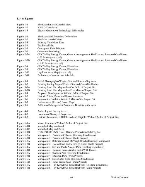
List of Figures<br />
Figure 1-1<br />
Figure 1-2<br />
Figure 1-3<br />
Figure 2-1.<br />
Figure 2-2.<br />
Figure 2-3.<br />
Figure 2-4.<br />
Figure 2-5.<br />
Figure 2-6.<br />
Figure 2-7A.<br />
Figure 2-7B.<br />
Figure 2-8.<br />
Figure 2-9.<br />
Figure 2-10.<br />
Figure 2-11<br />
Figure 3-1<br />
Figure 3-2<br />
Figure 3-3A<br />
Figure 3-3B<br />
Figure 3-4<br />
Figure 3-5<br />
Figure 3-6<br />
Figure 3-7<br />
Figure 3-8<br />
Figure 4-1.<br />
Figure 4-2.<br />
Figure 4-3.<br />
Figure 5-1A<br />
Figure 5-1B<br />
Figure 5-1C<br />
Figure 5-1D<br />
Figure 5-2A<br />
Figure 5-2B<br />
Figure 5-3A<br />
Figure 5-3B<br />
Figure 5-4A<br />
Figure 5-4B<br />
Figure 5-5A<br />
Figure 5-5B<br />
Figure 5-6A<br />
Figure 5-6B<br />
Figure 5-7A<br />
Figure 5-7B<br />
Site Location Map, Aerial View<br />
NYISO Zone Map<br />
Electric Generation Technology Efficiencies<br />
Site Locus and Boundary Delineation<br />
Site Map - Aerial View<br />
Existing Conditions Plan<br />
Tax Parcel Map<br />
Conceptual Flow Diagram<br />
Computer Rendering<br />
CPV Valley <strong>Energy</strong> Center, General Arrangement Site Plan and Proposed Conditions<br />
(100 Scale) (oversized)<br />
CPV Valley <strong>Energy</strong> Center, General Arrangement Site Plan and Proposed Conditions<br />
(11 50 Scale (oversized)<br />
CPV Valley <strong>Energy</strong> Center, Elevations<br />
CPV Valley <strong>Energy</strong> Center, Elevations<br />
Laydown Area Map (oversized)<br />
Preliminary Construction Schedule<br />
Aerial Photograph of Project Site and Surrounding Area<br />
Existing Zoning Map of Project Site and One-Mile Radius<br />
Existing Land Use Map within One Mile of Project Site<br />
Existing Land Use Map within Five Miles of Project Site<br />
Proposed Developments Within 1 Mile of Project Site<br />
Historic Points, Parks and Recreation Areas<br />
Community Facilities Within 5 Miles of the Project Site<br />
Undeveloped (Recent) Parcel Map<br />
Additional Management Zones and Districts in the Area<br />
Archeological Survey Area<br />
Location of Surveyed Properties<br />
Historic Resources, NRHP Listed and Eligible, Within 2 Miles of Project Site<br />
Visual Resources Within 5 Miles of Project Site<br />
Viewshed Map on Aerial<br />
Viewshed Map on USGS<br />
NYSHPO SPHINX Data – Historic Properties (D/I) Eligible<br />
Viewpoint 1: Paramount Theater (Existing Conditions)<br />
Viewpoint 1: Paramount Theater (With Project)<br />
Viewpoint 2: Dolsontown and McVeigh Roads (Existing Conditions)<br />
Viewpoint 2: Dolsontown and McVeigh Roads (With Project)<br />
Viewpoint 3: Ben and Paula Amchir Park (Existing Conditions)<br />
Viewpoint 3: Ben and Paula Amchir Park (With Project)<br />
Viewpoint 4: Shannen Park (Existing Conditions)<br />
Viewpoint 4: Shannen Park (With Project)<br />
Viewpoint 5: Bates Gates Road (Existing Conditions)<br />
Viewpoint 5: Bates Gates Road (With Project)<br />
Viewpoint 6: 129 Kirbytown Road Backyard (Existing Conditions)<br />
Viewpoint 6: 129 Kirbytown Road Backyard (With Project)<br />
xxi<br />
Table of Contents


