Competitive Power Ventures, Inc. - Energy Highway
Competitive Power Ventures, Inc. - Energy Highway
Competitive Power Ventures, Inc. - Energy Highway
You also want an ePaper? Increase the reach of your titles
YUMPU automatically turns print PDFs into web optimized ePapers that Google loves.
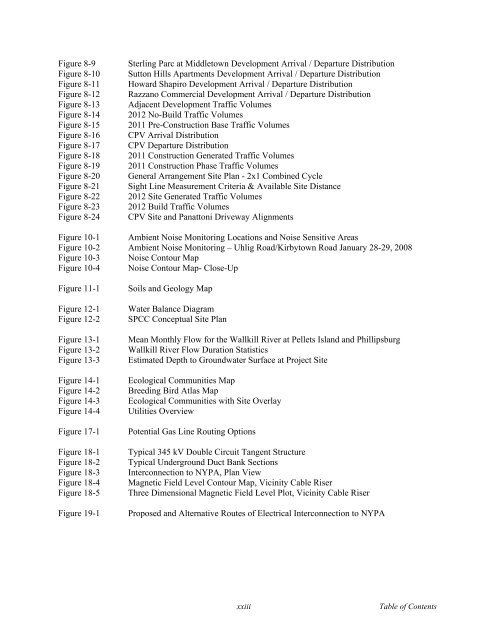
Figure 8-9<br />
Figure 8-10<br />
Figure 8-11<br />
Figure 8-12<br />
Figure 8-13<br />
Figure 8-14<br />
Figure 8-15<br />
Figure 8-16<br />
Figure 8-17<br />
Figure 8-18<br />
Figure 8-19<br />
Figure 8-20<br />
Figure 8-21<br />
Figure 8-22<br />
Figure 8-23<br />
Figure 8-24<br />
Sterling Parc at Middletown Development Arrival / Departure Distribution<br />
Sutton Hills Apartments Development Arrival / Departure Distribution<br />
Howard Shapiro Development Arrival / Departure Distribution<br />
Razzano Commercial Development Arrival / Departure Distribution<br />
Adjacent Development Traffic Volumes<br />
2012 No-Build Traffic Volumes<br />
2011 Pre-Construction Base Traffic Volumes<br />
CPV Arrival Distribution<br />
CPV Departure Distribution<br />
2011 Construction Generated Traffic Volumes<br />
2011 Construction Phase Traffic Volumes<br />
General Arrangement Site Plan - 2x1 Combined Cycle<br />
Sight Line Measurement Criteria & Available Site Distance<br />
2012 Site Generated Traffic Volumes<br />
2012 Build Traffic Volumes<br />
CPV Site and Panattoni Driveway Alignments<br />
Figure 10-1 Ambient Noise Monitoring Locations and Noise Sensitive Areas<br />
Figure 10-2 Ambient Noise Monitoring – Uhlig Road/Kirbytown Road January 28-29, 2008<br />
Figure 10-3 Noise Contour Map<br />
Figure 10-4 Noise Contour Map- Close-Up<br />
Figure 11-1<br />
Figure 12-1<br />
Figure 12-2<br />
Figure 13-1<br />
Figure 13-2<br />
Figure 13-3<br />
Figure 14-1<br />
Figure 14-2<br />
Figure 14-3<br />
Figure 14-4<br />
Figure 17-1<br />
Figure 18-1<br />
Figure 18-2<br />
Figure 18-3<br />
Figure 18-4<br />
Figure 18-5<br />
Figure 19-1<br />
Soils and Geology Map<br />
Water Balance Diagram<br />
SPCC Conceptual Site Plan<br />
Mean Monthly Flow for the Wallkill River at Pellets Island and Phillipsburg<br />
Wallkill River Flow Duration Statistics<br />
Estimated Depth to Groundwater Surface at Project Site<br />
Ecological Communities Map<br />
Breeding Bird Atlas Map<br />
Ecological Communities with Site Overlay<br />
Utilities Overview<br />
Potential Gas Line Routing Options<br />
Typical 345 kV Double Circuit Tangent Structure<br />
Typical Underground Duct Bank Sections<br />
Interconnection to NYPA, Plan View<br />
Magnetic Field Level Contour Map, Vicinity Cable Riser<br />
Three Dimensional Magnetic Field Level Plot, Vicinity Cable Riser<br />
Proposed and Alternative Routes of Electrical Interconnection to NYPA<br />
xxiii<br />
Table of Contents


