- Page 1 and 2:
Ocean* application development fram
- Page 3 and 4:
Copyright © 2008 Schlumberger. All
- Page 5 and 6:
Contents 1 Information Resources .
- Page 7 and 8:
LatticeInfo Class . . . . . . . . .
- Page 9 and 10:
1 Information Resources In This Sec
- Page 11 and 12:
Schlumberger Product Documentation
- Page 13 and 14:
2 Introduction In This Chapter The
- Page 15 and 16:
The Ocean Advantage The Ocean Advan
- Page 17 and 18:
The Ocean Architecture The Ocean Se
- Page 19 and 20:
The Ocean Architecture Applications
- Page 21 and 22:
Ocean Processes Ocean Processes Pro
- Page 23 and 24:
Petrel Data Domain - Pillar Grid -
- Page 25 and 26:
User Interface Infrastructure 5. Co
- Page 27 and 28:
3 Ocean Core In This Chapter Introd
- Page 29 and 30:
The Ocean Module The Ocean Module T
- Page 31 and 32:
The Ocean Module ModuleManager also
- Page 33 and 34:
The Ocean Module between different
- Page 35 and 36:
The Ocean Module It is also possibl
- Page 37 and 38:
The Ocean Module When initializatio
- Page 39 and 40:
The Ocean Module components will be
- Page 41 and 42:
The Ocean Module Module Dependency
- Page 43 and 44:
The Ocean Module The ModuleManager
- Page 45 and 46:
The Ocean Module // create a Module
- Page 47 and 48:
The Ocean Module Product families (
- Page 49 and 50:
The Ocean Module The Description an
- Page 51 and 52:
CoreLogger Class Fig. 3-7 Categoriz
- Page 53 and 54:
CoreSystem Class It defines several
- Page 55 and 56:
CoreSystem Class The AddModules met
- Page 57 and 58:
CoreSystem Class • Initializing -
- Page 59 and 60:
CoreSystem Class available until af
- Page 61 and 62:
Data Management Data Management The
- Page 63 and 64:
Data Management Data Sources The Da
- Page 65 and 66:
Data Management It implements IData
- Page 67 and 68:
Data Management The following code
- Page 69 and 70:
Data Management The ITransaction in
- Page 71 and 72:
Data Management The Abandon method
- Page 73 and 74:
Data Management IWorkspace Interfac
- Page 75 and 76:
Data Management The events handlers
- Page 77 and 78:
Droid Class the Droid string can in
- Page 79 and 80:
ServiceLocator Class ServiceLocator
- Page 81 and 82:
ServiceLocator Class RemoveService
- Page 83 and 84:
Description Interfaces and Classes
- Page 85 and 86:
Description Interfaces and Classes
- Page 87 and 88:
4 Ocean Services In This Chapter Ba
- Page 89 and 90:
Basics public object Clone (); publ
- Page 91 and 92:
Basics public object Clone (); publ
- Page 93 and 94:
Basics } public static Index4 opera
- Page 95 and 96:
Basics * (multiplication) Index3 id
- Page 97 and 98:
Basics IsAllNegative - This method
- Page 99 and 100:
Product - This method returns an in
- Page 101 and 102:
Basics public object Clone(); publi
- Page 103 and 104:
Basics public double I { get; set;
- Page 105 and 106:
Basics public static IndexDouble4 o
- Page 107 and 108:
Basics Each Index type has multiple
- Page 109 and 110:
Basics == (equal to) if (idx_double
- Page 111 and 112:
Basics IsAllNonPositive - This meth
- Page 113 and 114:
Basics dimension is defined by a st
- Page 115 and 116:
Basics The definition of the IndexR
- Page 117 and 118:
The IndexRange2, IndexRange3, and I
- Page 119 and 120:
Basics public Index2 Back { get; }
- Page 121 and 122:
Basics Length - This property retur
- Page 123 and 124:
Basics The definition Extent2 is: p
- Page 125 and 126:
Basics The contained Extent objects
- Page 127 and 128:
Basics the earlier example and an I
- Page 129 and 130:
outside the range of the second Ext
- Page 131 and 132:
Basics Create an index Extent2 from
- Page 133 and 134:
extent, the last index is returned.
- Page 135 and 136:
Basics } public static Index2 Narro
- Page 137 and 138:
Basics Max - This method returns ma
- Page 139 and 140:
Basics returned value is less than
- Page 141 and 142:
Geometry The definition of the Poin
- Page 143 and 144:
Geometry Each point class has multi
- Page 145 and 146:
Geometry != Operator - This operati
- Page 147 and 148:
Geometry The Point2 version of this
- Page 149 and 150:
ToString - This method gets a strin
- Page 151 and 152:
Geometry The definition of the Vect
- Page 153 and 154:
Geometry MaxValue - This method ret
- Page 155 and 156:
Geometry Vector3 vt1 = new Vector3(
- Page 157 and 158:
Geometry IsNull - This method deter
- Page 159 and 160:
Geometry The Direction3 class is de
- Page 161 and 162:
Geometry Direction2 and Direction3
- Page 163 and 164:
Geometry IsNull - This method deter
- Page 165 and 166:
Geometry The Box3 class is defined
- Page 167 and 168:
Geometry != Operator - This operati
- Page 169 and 170:
Geometry The Segment2 class definit
- Page 171 and 172: Geometry Here is construction from
- Page 173 and 174: Geometry Null - This method defines
- Page 175 and 176: Geometry a rectangular area on the
- Page 177 and 178: Geometry false. This implies that t
- Page 179 and 180: array values for corners 0, 1, and
- Page 181 and 182: Geometry diagonal distance across a
- Page 183 and 184: Geometry Direction3 objects. The fo
- Page 185 and 186: Geometry + Operator - This operatio
- Page 187 and 188: Geometry You can also use a constru
- Page 189 and 190: Geometry Equals - This method compa
- Page 191 and 192: Geometry The Polyline2 and Polyline
- Page 193 and 194: Geometry The Ray2 class definition
- Page 195 and 196: This is construction from two point
- Page 197 and 198: Geometry Negate - This method retur
- Page 199 and 200: Geometry public sealed class Spheri
- Page 201 and 202: Geometry Theta - This property gets
- Page 203 and 204: Geometry GetCartesianFromPolar - Th
- Page 205 and 206: Units Base Measurement A base measu
- Page 207 and 208: Units Units are represented by a sy
- Page 209 and 210: or OSDD. Measurements and units may
- Page 211 and 212: Units IUnitService is defined as: p
- Page 213 and 214: measurements. IUnitCatalog can acce
- Page 215 and 216: Units Below is an example using IUn
- Page 217 and 218: Units Units The IUnit interface pro
- Page 219 and 220: The IUnitConverter.Convert method i
- Page 221: system. From the two unit system re
- Page 225 and 226: Coordinate Systems using the GetAll
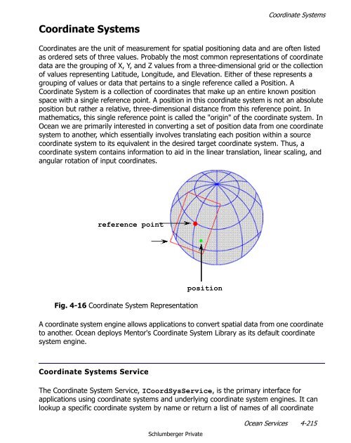
- Page 227 and 228: Coordinate Systems The following co
- Page 229 and 230: Coordinate Systems These methods pr
- Page 231 and 232: Coordinate Systems // Initialize th
- Page 233 and 234: Coordinate Systems The example uses
- Page 235 and 236: Get the coordinate system service.
- Page 237 and 238: The ILogChannelCatalog service has
- Page 239 and 240: 5 Petrel Convenience Classes In Thi
- Page 241 and 242: PetrelProject Class PetrelProject C
- Page 243 and 244: Project class is actually the top l
- Page 245 and 246: PetrelProject Class Fig. 5-1 Tabs A
- Page 247 and 248: PetrelSystem Property Interface or
- Page 249 and 250: PetrelLogger Class public static vo
- Page 251 and 252: PetrelLogger Class Using the warnin
- Page 253 and 254: PetrelLogger Class Fig. 5-6 InfoOut
- Page 255 and 256: PetrelLogger Class The config file
- Page 257 and 258: PetrelLogger Class informational ic
- Page 259 and 260: PetrelLogger Class range defined an
- Page 261 and 262: PetrelLogger Class progress bar exe
- Page 263 and 264: PetrelUnitSystem Class public stati
- Page 265 and 266: Template Catalog Template Catalog T
- Page 267 and 268: Template Catalog It can also conver
- Page 269 and 270: Template Catalog Find Display Units
- Page 271 and 272: 6 Workflow In This Chapter Overview
- Page 273 and 274:
Overview Each workstep takes input
- Page 275 and 276:
Overview An example workflow is the
- Page 277 and 278:
Overview Workflow Editor The Workfl
- Page 279 and 280:
Overview The line UI is a quick way
- Page 281 and 282:
Overview Processes are not dependen
- Page 283 and 284:
Overview Process UI Each process ha
- Page 285 and 286:
Overview An interactive process has
- Page 287 and 288:
Overview Workstep vs. Process As we
- Page 289 and 290:
Feature Workstep Process Default UI
- Page 291 and 292:
Custom Worksteps Custom Worksteps T
- Page 293 and 294:
Custom Worksteps The example workst
- Page 295 and 296:
Custom Worksteps Your workstep is n
- Page 297 and 298:
Custom Worksteps Our example showin
- Page 299 and 300:
Custom Worksteps You can have Ocean
- Page 301 and 302:
Here is our argument package exampl
- Page 303 and 304:
Custom Worksteps You can assign the
- Page 305 and 306:
Using the convenience class is the
- Page 307 and 308:
You would typically use the Describ
- Page 309 and 310:
Custom Worksteps How to Write a Wor
- Page 311 and 312:
Custom Worksteps We will implement
- Page 313 and 314:
Custom Worksteps The system will cr
- Page 315 and 316:
Custom Worksteps The argument packa
- Page 317 and 318:
Custom Worksteps Adding this implem
- Page 319 and 320:
Custom Worksteps IDescriptionSource
- Page 321 and 322:
Custom Worksteps This will populate
- Page 323 and 324:
Custom Worksteps • Implement butt
- Page 325 and 326:
Custom Worksteps package has change
- Page 327 and 328:
Custom Worksteps The Cancel button
- Page 329 and 330:
All custom worksteps are added in t
- Page 331 and 332:
Custom Worksteps When the TestWorkf
- Page 333 and 334:
Custom Processes The custom process
- Page 335 and 336:
You inherit from Process and provid
- Page 337 and 338:
Custom Processes The end user doubl
- Page 339 and 340:
Custom Processes Step 4 - Optionall
- Page 341 and 342:
Custom Processes Step 7 - Add the P
- Page 343 and 344:
Custom Processes public static clas
- Page 345 and 346:
Custom Processes This adds the proc
- Page 347 and 348:
Custom Processes How to Make a Proc
- Page 349 and 350:
Custom Processes The wrapper re-use
- Page 351 and 352:
Custom Processes Now we need to rew
- Page 353 and 354:
Index A About Schlumberger 2 Almost
- Page 355 and 356:
LocalTransform 221 LogChannelCatalo