SUB-COMMITTEE ON STABILITY AND LOAD LINES AND ON ...
SUB-COMMITTEE ON STABILITY AND LOAD LINES AND ON ...
SUB-COMMITTEE ON STABILITY AND LOAD LINES AND ON ...

You also want an ePaper? Increase the reach of your titles
YUMPU automatically turns print PDFs into web optimized ePapers that Google loves.
Ref.: 391/09 and 520/09<br />
BSU<br />
Bundesstelle für Seeunfalluntersuchung<br />
Federal Bureau of Maritime Casualty Investigation<br />
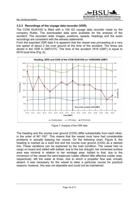
3.2.3 Recordings of the voyage data recorder (VDR)<br />
The CCNI GUAYAS is fitted with a 100 G2 voyage data recorder made by the<br />
company Rutter. The downloaded data were available for the analysis of the<br />
accident. The recorded radar images, positions, speeds, headings and the audio<br />
recordings are consistent with the witness statements.<br />
From the exported VDR data it is apparent that the vessel was proceeding at a very<br />
low speed of about 2 kts over ground at the time of the accident. The times are<br />
stored in the VDR in GMT/UTC. The time of the accident 1618 (GMT) is equal to<br />
0018 local time (Fig. 6).<br />
350,0<br />
Heading, SOG and und COG der of the CCNI CCNI GUAYAS GUAYAS am 14.09.2009 on 14/09/2009 (GMT) (GMT)<br />
3,50<br />
300,0<br />
3,00<br />
Course Kurs [Grad] [deg.]<br />
250,0<br />
200,0<br />
150,0<br />
100,0<br />
2,50<br />
2,00<br />
1,50<br />
1,00<br />
Speed[knots]<br />
Geschwindigkeit [Knoten]<br />
50,0<br />
0,50<br />
Time Unfallzeitpunkt of the accident 16:18 1618 (GMT) [GMT]<br />
0,0<br />
0,00<br />
16:10 16:11 16:12 16:13 16:14 16:15 16:16 16:17 16:18 16:19 16:20 16:21 16:22 16:23 16:24 16:25<br />
Time Uhrzeit [GMT] [GMT]<br />
Heading [Grad] [deg.] COG [Grad] [deg.] SOG [Knoten] [knots]<br />
Figure 7: Analysis of the VDR data<br />
The heading and the course over ground (COG) differ substantially from each other,<br />
in the order of 90°-100°. This means that the vessel must have had considerable<br />
problems in actually keeping her course. On the following chart, Figure 8, the<br />
heading is marked as a solid line and the course over ground (COG) as a dashed<br />
line. These variations can be explained by the load condition. The vessel had no<br />
cargo on board and sailed with ballast; due to the low draught, her immersed surface<br />
area was minimal in relation to her windage area. Added to that, due to the<br />
immersion of the vessel the semi-balanced rudder offered little effective rudder area,<br />
respectively, left the water at times, due to which a propeller flow was virtually<br />
absent. It was necessary for the vessel to steer a particular course for practical<br />
reasons; however, this was not steerable and could not be maintained.<br />
_____________________________________________________________________________________________________<br />
Page 16 of 71