Native Habitat Inventory Final Report 2004 - St. Lucie County
Native Habitat Inventory Final Report 2004 - St. Lucie County
Native Habitat Inventory Final Report 2004 - St. Lucie County

You also want an ePaper? Increase the reach of your titles
YUMPU automatically turns print PDFs into web optimized ePapers that Google loves.
first created. Then a current 2002 land cover was created. For each coverage, all<br />
polygons (more than 132,000) were classified as natural or non-natural. The difference<br />
between these two coverages provided the acres of natural habitat lost and the number of<br />
acres conserved over the time period.<br />
By 2002, 19,417 acres of land had been conserved. However, in comparison to the<br />
surrounding counties this is quite low (Table 2). Also, the natural areas that remain are<br />
highly fragmented.<br />
Table 2. Comparison of Area Preserved by <strong>County</strong> as of December 2003<br />
Source: FNAI Managed Areas shapefile December 2003<br />
<strong>County</strong> Total Acres within<br />
the <strong>County</strong><br />
Total Acres<br />
Conserved<br />
Percent of the<br />
<strong>County</strong> Conserved<br />
<strong>St</strong>. <strong>Lucie</strong> 391,700 19,417 5<br />
Indian River 318,080 >100,000 31<br />
Okeechobee 493,440 >75,000 15<br />
Martin 355,200 >66,000 19<br />
Site Data Summaries<br />
The <strong>County</strong> ESL Program goals of increasing acreage of native habitat preserved as well<br />
as preservation of unique communities and species requires the use of both countywide<br />
and more site-specific, localized ecological information to make wise land-use and land<br />
planning decisions. This need for site-specific information was the basis for conducting<br />
this inventory.<br />
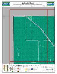
The 30 sites (40,142 acres) that were surveyed represented different vegetative<br />
communities and locations in the <strong>County</strong>. The vegetative communities of the sites<br />
ranged from coastal uplands to wet flatlands. The sites ranged in size from 1 acre to<br />
28,789 acres. Table 3 provides a summary of the ecological characteristics including<br />
content and context for all the sites. Figure 1 provides a map of the A, B, and C-ranked<br />
sites.<br />
Four sites (4, 9, 43, and 44) were not accessible by ground due to constraints of owner<br />
access (31,499 acres). They were assessed via helicopter by county staff. All four of these<br />
sites are expected to be of high quality based on other data sources (e.g., Fernauld 1989,<br />
Johnson and Muller 1990, KBN 1992) and the aerial reconnaissance.<br />
In the eastern third of the county the natural resources on a site were most affected by<br />
development, whereas, in the western two-thirds of the county they were influenced by<br />
intensive agriculture (e.g., cattle grazing and citrus groves). This is true for both uplands<br />
and wetlands. Agricultural activities directly impact an area by replacing or removing the<br />
overstory, removing small scale topographic variation, collapsing the original<br />
multilayered vegetation structure into fewer layers, altering species richness and<br />
5