- Page 1 and 2: St. Lucie County Native Habitat Inv
- Page 3 and 4: Table of Contents Acknowledgements
- Page 5 and 6: Appendix E. List of Rare Species th
- Page 7 and 8: Acknowledgements Pandion Systems wo
- Page 9 and 10: Glossary ACI - Area of Conservation
- Page 11 and 12: Executive Summary The overall objec
- Page 13 and 14: The Site Data Summaries and Ranks s
- Page 15 and 16: • To identify and prioritize land
- Page 17 and 18: The species-area relationship does
- Page 19 and 20: composition through selective grazi
- Page 21 and 22: Site No Site Rank Overall Ecologica
- Page 23 and 24: The Site Data Summaries and Ranks s
- Page 25 and 26: 5 -- Slated for development or prim
- Page 27 and 28: 5 -- Directly contiguous with large
- Page 29 and 30: Methods and Results Overview This p
- Page 31 and 32: Project Team made a judgment call o
- Page 33 and 34: Figure 3. St. Lucie County 2002 Nat
- Page 35: Discussion of Methodology The limit
- Page 39 and 40: Inventory of Existing Native Upland
- Page 41 and 42: Number Polygons 49 385 1,318 FLUCCS
- Page 43 and 44: Despite these exceptions, most spec
- Page 45 and 46: Table 10. Summary of FLUCCS Types a
- Page 47 and 48: SITE NAME FLUCCS Descriptions FLUCC
- Page 49 and 50: SITE NAME FLUCCS Descriptions FLUCC
- Page 51 and 52: Table 11. Comparison of the Amount
- Page 53 and 54: FLUCCS Number FLUCCS Description Ac
- Page 55 and 56: mixed landowner response. Ultimatel
- Page 57 and 58: Developing Field Data Collection Ma
- Page 59 and 60: Table 12. Example of Calculation of
- Page 61 and 62: influences rather than natural infl
- Page 63 and 64: FLUCCS FLUCCS Description 213 Sum o
- Page 65 and 66: FLUCCS FLUCCS Description FNAI Assi
- Page 67 and 68: FLUCCS FLUCCS Description FNAI Assi
- Page 69 and 70: FLUCCS FLUCCS Description FNAI Assi
- Page 71 and 72: southeastern kestrel, Florida sandh
- Page 73 and 74: Site 4N. FNAI Natural Communities L
- Page 75: Site 4S. FNAI Natural Communities L
- Page 78 and 79: Table 2. Community Types present on
- Page 81 and 82: Site Number: 24 Site Rank: A Total
- Page 83 and 84: Common Name Scientific Name FLEPPC
- Page 85 and 86: Site 24. Rare Species [´ hg [´ hg
- Page 88 and 89:
Site Number: 25 Site Rank: A Total
- Page 90 and 91:
Site 25. FNAI Natural Communities L
- Page 92:
Site 25. Invasive Exotic Species qp
- Page 95 and 96:
Site History/Habitat Disturbance -
- Page 97 and 98:
SIte 41. Rare Species Legend qp Cha
- Page 100 and 101:
Site Number: 42 Site Rank: A/B Tota
- Page 102 and 103:
Ownership/Notes - The west part is
- Page 104 and 105:
Site 42. Rare Species [ [ [ [ Legen
- Page 107 and 108:
Site Number: 43 Site Rank: A Total
- Page 109:
Site 43. FNAI Natural Communities L
- Page 112 and 113:
Ownership/Notes - Permission for gr
- Page 114 and 115:
101
- Page 116 and 117:
Hydrology - The hydrology has been
- Page 118 and 119:
Site 50. FNAI Natural Communities L
- Page 120 and 121:
107
- Page 122 and 123:
Site History/Habitat Disturbance -
- Page 124 and 125:
SIte 51. Rare Species Legend [ Goph
- Page 126 and 127:
113
- Page 128 and 129:
Canals surround the site but the si
- Page 130 and 131:
Site 3. Invasive Exotic Species qp
- Page 132 and 133:
Site Number: 7 Site Rank: B Total A
- Page 134 and 135:
Management for this site will be th
- Page 136 and 137:
Site 7. Invasive Exotic Species qp
- Page 138 and 139:
Site Number: 11 Site Rank: B Total
- Page 140 and 141:
Table 4. Invasive Exotic Species ob
- Page 142 and 143:
Site 11. Rare Species * [` l Legend
- Page 144 and 145:
131
- Page 146 and 147:
vegetation observed. There are some
- Page 148 and 149:
Site 13. FNAI Natural Communities L
- Page 150 and 151:
137
- Page 152 and 153:
Proximity to primary and secondary
- Page 154 and 155:
Site 14. FNAI Natural Communities L
- Page 156 and 157:
143
- Page 158 and 159:
Table 2. Community Types present on
- Page 160 and 161:
Site 15. Rare Species "e "e Legend
- Page 162 and 163:
149
- Page 164 and 165:
Site History/Habitat Disturbance -
- Page 166 and 167:
Site 18. Rare Species Legend !F Gru
- Page 168 and 169:
155
- Page 170 and 171:
Fork of the St. Lucie which is the
- Page 172 and 173:
Site 20. FNAI Natural Communities L
- Page 174 and 175:
161
- Page 176 and 177:
Site History/Habitat Disturbance- T
- Page 178 and 179:
Site 28. Rare Species [ [¨ ih hg [
- Page 180 and 181:
167
- Page 182 and 183:
Table 3. Listed Species observed. C
- Page 184 and 185:
Site 30. Rare Species ih [ [ [¨[ l
- Page 186 and 187:
173
- Page 188 and 189:
Hydrology - The overall hydrologica
- Page 190 and 191:
177
- Page 192 and 193:
Table 3. Listed Species observed. C
- Page 194 and 195:
Site 16. Invasive Exotic Species Le
- Page 196 and 197:
Site Number: 17 Site Rank: C Total
- Page 198 and 199:
Site 17. FNAI Natural Communities L
- Page 200 and 201:
187
- Page 202 and 203:
Hydrology - The vegetation at the t
- Page 204 and 205:
Site 19. Invasive Exotic Species qp
- Page 206 and 207:
Site Number: 26 Site Rank: C Total
- Page 208 and 209:
Site 26. FNAI Natural Communities L
- Page 210 and 211:
Site 26. Invasive Exotic Species ¡
- Page 212 and 213:
Site Number: 27 Site Rank: C Total
- Page 214 and 215:
Site 27. FNAI Natural Communities L
- Page 216 and 217:
¡£ qp Site 27. Invasive Exotic Sp
- Page 218 and 219:
Site Number: 31 Site Rank: C Total
- Page 220 and 221:
Site 31. FNAI Natural Communities L
- Page 222 and 223:
Site 31. Invasive Exotic Species ¡
- Page 224 and 225:
Site Number: 32 Site Rank: C Total
- Page 226 and 227:
Site 32. FNAI Natural Communities L
- Page 228 and 229:
Site 32. Invasive Exotic Species ¡
- Page 230 and 231:
Site Number: 34 Site Rank: C Total
- Page 232 and 233:
Site 34. FNAI Natural Communities L
- Page 234 and 235:
Site 34. Invasive Exotic Species ¡
- Page 236 and 237:
Site Number: 48 Site Rank: C Total
- Page 238 and 239:
Site 48. FNAI Natural Communities L
- Page 240 and 241:
Site 48. Invasive Exotic Species ¡
- Page 242 and 243:
Conclusions The opportunity for pre
- Page 244 and 245:
Bibliography Cooper RM, Ortel TW. 1
- Page 246 and 247:
Lenze DG. 2002. Florida Long-term E
- Page 248 and 249:
Appendices Appendix A. Explanation
- Page 250 and 251:
Definitions derived from U.S. Endan
- Page 252 and 253:
Appendix B. Rare Species Observed R
- Page 254 and 255:
Appendix D. Natural Communities Obs
- Page 256 and 257:
Scientific Name Common Name Coelora
- Page 258 and 259:
Scientific Name Common Name Federal
- Page 260 and 261:
Scientific Name Common Name Federal
- Page 262 and 263:
Scientific Name Common Name Federal
- Page 264 and 265:
Scientific Name Common Name Federal
- Page 266 and 267:
Scientific Name Global Occurrence S
- Page 268 and 269:
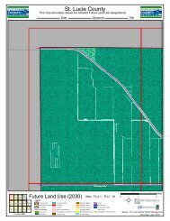
BOARD OF COUNTY COMMISSIONERS PUBLI
- Page 270 and 271:
Appendix H. Mapping Discussion This
- Page 272 and 273:
Appendix I. Conversion of FLUCCS Ca
- Page 274 and 275:
FLUCCS FLUCCS Description FNAI Assi
- Page 276 and 277:
FLUCCS to FNAI Conversion Improved
- Page 278 and 279:
FLUCCS to FNAI Conversion Mixed Ran
- Page 280 and 281:
FLUCCS to FNAI Conversion Lakes
- Page 282 and 283:
Table 13. Community Conversion from
- Page 284 and 285:
FLUCCS FLUCCS Description FNAI Assi
- Page 286 and 287:
FLUCCS to FNAI Conversion Longleaf
- Page 288 and 289:
FLUCCS to FNAI Conversion Hardwood-
- Page 290 and 291:
FLUCCS to FNAI Conversion Wetland F
- Page 292 and 293:
FLUCCS to FNAI Conversion Cypress w