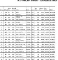
UNIVERSITY OF KERALA - College of Engineering, Trivandrum
UNIVERSITY OF KERALA - College of Engineering, Trivandrum
UNIVERSITY OF KERALA - College of Engineering, Trivandrum

Create successful ePaper yourself
Turn your PDF publications into a flip-book with our unique Google optimized e-Paper software.
08. 506. 2. Elective-I GEOMATICS<br />
L T P/D Cr<br />
3 0 0 3<br />
Module I<br />
Fundamentals <strong>of</strong> GIS : Definition-components <strong>of</strong> GIS-GIS operations-Coordinate systems-Geographic<br />
coordinate systems-Map projections-Projected coordinate systems-Spatial data modelling-Raster and vector data<br />
representation-Data Input methods-Geometric Transformation-RMS error, Vector data Analysis-buffering,<br />
overlay, Modelling surfaces-DTM, Triangulated irregular network (brief description only)-GIS output.<br />
Module II<br />
Introduction to Remote Sensing : Definition- Electromagnetic spectrum-Energy interactions with atmosphere<br />
and earth surface features-spectral reflectance <strong>of</strong> vegetation, soil and water- Classification <strong>of</strong> sensors-spatial<br />
resolution-spectral resolution-radiometric resolution-Temporal resolution- Optical Infra red sensors-Active and<br />
Passive sensors-Multi spectral scanning-Along track scanning, across track scanning, IRS LISS Camera-<br />
Thermal detection-Microwave sensing (brief description only)-Visual Image Interpretation –Indian Remote<br />
Sensing System.<br />
Module III<br />
GPS Basics- system overview-working principle <strong>of</strong> GPS-Satellite ranging-calculating position- Ranging errors<br />
and its correction-code phase and carrier phase measurements-application <strong>of</strong> GPS Surveying methods-Static,<br />
Rapid static , Kinematic methods -Real time and post processing DGPS-GPS Survey planning and observationhorizontal<br />
and vertical control-data sheet-visibility diagram-GPS data processing-WAAS system-Hydrographic<br />
surveying with GPS.<br />
References<br />
1. Arora K.R., “Surveying-Vol 3”, Standard Book House<br />
2. Satheesh Gopi, Madhu N & Sathikumar R., “Advanced Surveying”, Pearson Education, 2004<br />
3. Barry F K, “Geomatics”, Pearson Education Ltd.<br />
4. Satheesh Gopi, “The Global Positioning System and Surveying”, Pearson Education ,2004<br />
5. Heywood, Cornelius and Carver, “ An introduction to GIS”, Pearson Education Ltd<br />
6. Chang,K , “Introduction to Geographic Information Systems”, Tata McGraw-Hill Publishing Co. Ltd,<br />
2008<br />
7. Anji Reddy M., “ Remote sensing and Geographical Information Systems”, B S Publications,<br />
Hyderabad, 2001<br />
8. George Joseph, “Fundamentals <strong>of</strong> Remote Sensing”, University Press, 2003<br />
9. Lillesand M and Kiefer W, “Remote Sensing and Image Interpretation”. John iley and Sons,Inc.,2000<br />
10. Iliffe, C.J., Datums and Map Projections for Remote Sensing, GIS and Surveying, Whittles Publishing,<br />
2006<br />
11. Burrough P , Principles <strong>of</strong> Geographical Information systems, Oxford University Press<br />
12. Kang-tsung chang, ‘Introduction to GIS’ , Tata McGraw-Hill Publishing Co. Ltd<br />
Question paper<br />
Duration: 3 Hrs<br />
The Question paper consists <strong>of</strong> Part A and Part B.<br />
Part A carries 8 compulsory questions (short answer questions) covering the entire syllabus and is for 40<br />
marks.<br />
Part B is for 60 marks. There will be two questions from each module. The candidate has to answer one<br />
question out <strong>of</strong> two.<br />
Note: No charts, tables, codes are permitted in the Examination hall .If necessary relevant data shall be given<br />
along with the question paper by the question paper setter.<br />
49