European Geologist European Geologist Geoheritage - learning ...
European Geologist European Geologist Geoheritage - learning ...
European Geologist European Geologist Geoheritage - learning ...

Create successful ePaper yourself
Turn your PDF publications into a flip-book with our unique Google optimized e-Paper software.
Topical - <strong>Geoheritage</strong><br />
interest to the general public from those<br />
for professionals, c) makes the production,<br />
presentation and publishing of a map database<br />
possible and d) can be continuously<br />
updated. The table header and therefore its<br />
content are still under development. This<br />
table contains the data of more than 400<br />
geological key sections registered by the<br />
Hungarian Commission on Stratigraphy,<br />
and with the help of this table we have also<br />
started to develop the map database.<br />
In order to develop the map database,<br />
the best geological background must have<br />
been chosen. For this purpose the Geological<br />
Map of Hungary on a scale of 1: 200<br />
000 (Gyalog and Budai, 2007) was the most<br />
suitable.<br />
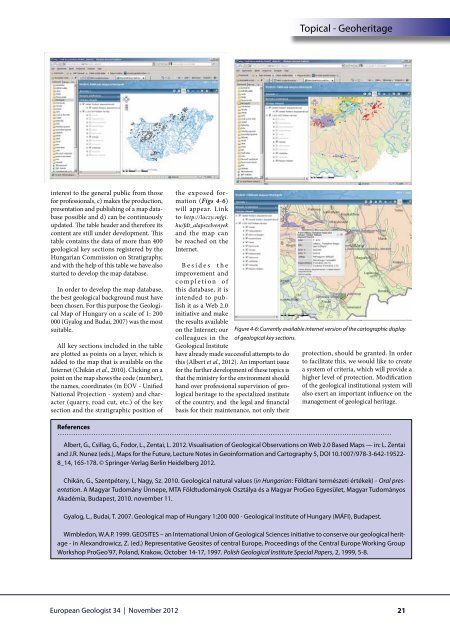
All key sections included in the table<br />
are plotted as points on a layer, which is<br />
added to the map that is available on the<br />
Internet (Chikán et al., 2010). Clicking on a<br />
point on the map shows the code (number),<br />
the names, coordinates (in EOV - Unified<br />
National Projection - system) and character<br />
(quarry, road cut, etc.) of the key<br />
section and the stratigraphic position of<br />
the exposed formation<br />
(Figs 4-6)<br />
will appear. Link<br />
to http://loczy.mfgi.<br />
hu/fdt_alapszelvenyek<br />
and the map can<br />
be reached on the<br />
Internet.<br />
Besides the<br />
improvement and<br />
completion of<br />
this database, it is<br />
intended to publish<br />
it as a Web 2.0<br />
initiative and make<br />
the results available<br />
on the Internet; our<br />
colleagues in the of geological key sections.<br />
Geological Institute<br />
have already made successful attempts to do<br />
this (Albert et al., 2012). An important issue<br />
for the further development of these topics is<br />
that the ministry for the environment should<br />
hand over professional supervision of geological<br />
heritage to the specialized institute<br />
of the country, and the legal and financial<br />
basis for their maintenance, not only their<br />
Figure 4-6: Currently available internet version of the cartographic display<br />
protection, should be granted. In order<br />
to facilitate this, we would like to create<br />
a system of criteria, which will provide a<br />
higher level of protection. Modification<br />
of the geological institutional system will<br />
also exert an important influence on the<br />
management of geological heritage.<br />
References<br />
Albert, G., Csillag, G., Fodor, L., Zentai, L. 2012. Visualisation of Geological Observations on Web 2.0 Based Maps — in: L. Zentai<br />
and J.R. Nunez (eds.), Maps for the Future, Lecture Notes in Geoinformation and Cartography 5, DOI 10.1007/978-3-642-19522-<br />
8_14, 165-178. © Springer-Verlag Berlin Heidelberg 2012.<br />
Chikán, G., Szentpétery, I., Nagy, Sz. 2010. Geological natural values (in Hungarian: Földtani természeti értékek) - Oral presentation.<br />
A Magyar Tudomány Ünnepe, MTA Földtudományok Osztálya és a Magyar ProGeo Egyesület, Magyar Tudományos<br />
Akadémia, Budapest, 2010. november 11.<br />
Gyalog, L., Budai, T. 2007. Geological map of Hungary 1:200 000 - Geological Institute of Hungary (MÁFI), Budapest.<br />
Wimbledon, W.A.P. 1999. GEOSITES – an International Union of Geological Sciences initiative to conserve our geological heritage<br />
- in Alexandrowicz, Z. (ed.) Representative Geosites of central Europe, Proceedings of the Central Europe Working Group<br />
Workshop ProGeo’97, Poland, Krakow, October 14-17, 1997. Polish Geological Institute Special Papers, 2, 1999, 5-8.<br />
<strong>European</strong> <strong>Geologist</strong> 34 | November 2012<br />
21