European Geologist European Geologist Geoheritage - learning ...
European Geologist European Geologist Geoheritage - learning ...
European Geologist European Geologist Geoheritage - learning ...

Create successful ePaper yourself
Turn your PDF publications into a flip-book with our unique Google optimized e-Paper software.
Topical - <strong>Geoheritage</strong><br />
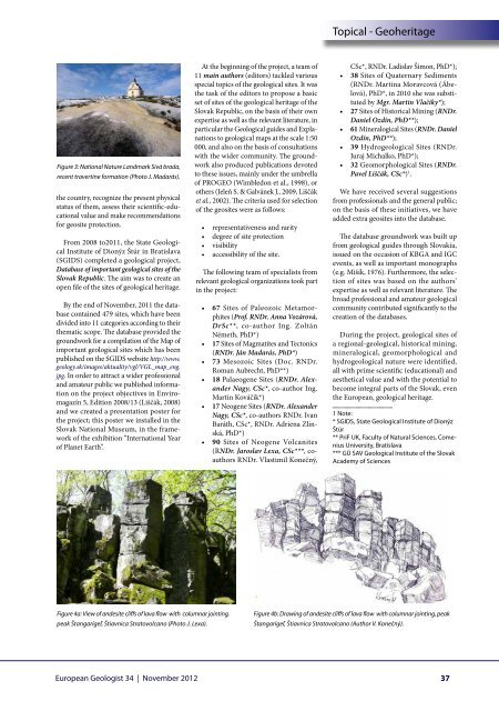
Figure 3: National Nature Landmark Sivá brada,<br />
recent travertine formation (Photo J. Madarás).<br />
the country, recognize the present physical<br />
status of them, assess their scientific-educational<br />
value and make recommendations<br />
for geosite protection.<br />
From 2008 to2011, the State Geological<br />
Institute of Dionýz Štúr in Bratislava<br />
(SGIDS) completed a geological project,<br />
Database of important geological sites of the<br />
Slovak Republic. The aim was to create an<br />
open file of the sites of geological heritage.<br />
By the end of November, 2011 the database<br />
contained 479 sites, which have been<br />
divided into 11 categories according to their<br />
thematic scope. The database provided the<br />
groundwork for a compilation of the Map of<br />
important geological sites which has been<br />
published on the SGIDS website http://www.<br />
geology.sk/images/aktuality/vgl/VGL_map_eng.<br />
jpg. In order to attract a wider professional<br />
and amateur public we published information<br />
on the project objectives in Enviromagazín<br />
5, Edition 2008/13 (Liščák, 2008)<br />
and we created a presentation poster for<br />
the project; this poster we installed in the<br />
Slovak National Museum, in the framework<br />
of the exhibition “International Year<br />
of Planet Earth”.<br />
At the beginning of the project, a team of<br />
11 main authors (editors) tackled various<br />
special topics of the geological sites. It was<br />
the task of the editors to propose a basic<br />
set of sites of the geological heritage of the<br />
Slovak Republic, on the basis of their own<br />
expertise as well as the relevant literature, in<br />
particular the Geological guides and Explanations<br />
to geological maps at the scale 1:50<br />
000, and also on the basis of consultations<br />
with the wider community. The groundwork<br />
also produced publications devoted<br />
to these issues, mainly under the umbrella<br />
of PROGEO (Wimbledon et al., 1998), or<br />
others (Jeleň S. & Galvánek J., 2009, Liščák<br />
et al., 2002). The criteria used for selection<br />
of the geosites were as follows:<br />
• representativeness and rarity<br />
• degree of site protection<br />
• visibility<br />
• accessibility of the site.<br />
The following team of specialists from<br />
relevant geological organizations took part<br />
in the project:<br />
• 67 Sites of Paleozoic Metamorphites<br />
(Prof. RNDr. Anna Vozárová,<br />
DrSc**, co-author Ing. Zoltán<br />
Németh, PhD*)<br />
• 17 Sites of Magmatites and Tectonics<br />
(RNDr. Ján Madarás, PhD*)<br />
• 73 Mesozoic Sites (Doc. RNDr.<br />
Roman Aubrecht, PhD**)<br />
• 18 Palaeogene Sites (RNDr. Alexander<br />
Nagy, CSc*, co-author Ing.<br />
Martin Kováčik*)<br />
• 17 Neogene Sites (RNDr. Alexander<br />
Nagy, CSc*, co-authors RNDr. Ivan<br />
Baráth, CSc*, RNDr. Adriena Zlinská,<br />
PhD*)<br />
• 90 Sites of Neogene Volcanites<br />
(RNDr. Jaroslav Lexa, CSc***, coauthors<br />
RNDr. Vlastimil Konečný,<br />
CSc*, RNDr. Ladislav Šimon, PhD*);<br />
• 38 Sites of Quaternary Sediments<br />
(RNDr. Martina Moravcová (Ábelová),<br />
PhD*, in 2010 she was substituted<br />
by Mgr. Martin Vlačiky*);<br />
• 27 Sites of Historical Mining (RNDr.<br />
Daniel Ozdín, PhD**);<br />
• 61 Mineralogical Sites (RNDr. Daniel<br />
Ozdín, PhD**);<br />
• 39 Hydrogeological Sites (RNDr.<br />
Juraj Michalko, PhD*);<br />
• 32 Geomorphological Sites (RNDr.<br />
Pavel Liščák, CSc*) 1 .<br />
We have received several suggestions<br />
from professionals and the general public;<br />
on the basis of these initiatives, we have<br />
added extra geosites into the database.<br />
The database groundwork was built up<br />
from geological guides through Slovakia,<br />
issued on the occasion of KBGA and IGC<br />
events, as well as important monographs<br />
(e.g. Mišík, 1976). Furthermore, the selection<br />
of sites was based on the authors’<br />
expertise as well as relevant literature. The<br />
broad professional and amateur geological<br />
community contributed significantly to the<br />
creation of the databases.<br />
During the project, geological sites of<br />
a regional-geological, historical mining,<br />
mineralogical, geomorphological and<br />
hydrogeological nature were identified,<br />
all with prime scientific (educational) and<br />
aesthetical value and with the potential to<br />
become integral parts of the Slovak, even<br />
the <strong>European</strong>, geological heritage.<br />
1 Note:<br />
* SGIDS, State Geological Institute of Dionýz<br />
Štúr<br />
** PriF UK, Faculty of Natural Sciences, Comenius<br />
University, Bratislava<br />
*** GÚ SAV Geological Institute of the Slovak<br />
Academy of Sciences<br />
Figure 4a: View of andesite cliffs of lava flow with columnar jointing,<br />
peak Štangarígeľ, Štiavnica Stratovolcano (Photo J. Lexa).<br />
Figure 4b: Drawing of andesite cliffs of lava flow with columnar jointing, peak<br />
Štangarígeľ, Štiavnica Stratovolcano (Author V. Konečný).<br />
<strong>European</strong> <strong>Geologist</strong> 34 | November 2012<br />
37