European Geologist European Geologist Geoheritage - learning ...
European Geologist European Geologist Geoheritage - learning ...
European Geologist European Geologist Geoheritage - learning ...

Create successful ePaper yourself
Turn your PDF publications into a flip-book with our unique Google optimized e-Paper software.
Topical - <strong>Geoheritage</strong><br />
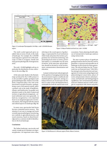
Figure 12: Landscape Physiographic Unit Map - scale 1:250.000 Abruzzo<br />
region. Figure 13: Map of habitat and land use, scale 1: 50.000.<br />
The multi-scaled approach gives an<br />
added value in terms of tools, to the study<br />
of landscape. For example, the 1:250.000<br />
scale map gives a general view of the landscape,<br />
in order to recognize, classify and<br />
map geomorphologically homogeneous<br />
areas.<br />
The scale 1: 50.000 highlights soil use, in<br />
particular the distribution of wine cultivation<br />
in the area (Fig. 13).<br />
At the same scale, thanks to the thematic<br />
maps produced by the CARG project it<br />
is also possible to gather geological and<br />
geomorphological data. Indeed, even if the<br />
biotic component plays a key role in the<br />
functional ecosystem dynamics, geology,<br />
being a part of all natural systems, plays<br />
a primary role in the study of landforms,<br />
climate, and biodiversity. In parallel, new<br />
attention is paid, in the study of nature and<br />
territory, to agricultural arrangement, cultural<br />
settlement and, more generally, to<br />
land use, recognized as a very important<br />
factor in an integrated approach to territorial<br />
analysis, that integrate both the natural<br />
and cultural aspects of a landscape (Fig. 14).<br />
In many cases, spectacular land forms<br />
become a potential tourist resource. This<br />
situation is not easy to manage and needs<br />
scientific/geomorphological monitoring,<br />
new outlooks in agricultural practice, and<br />
social consensus, based on shared knowledge<br />
and on a common model of identification<br />
in the local landscape.<br />
Conclusions<br />
referring to the social aspects of geoheritage,<br />
is represented by local institutions<br />
which study and protect the territory, programmes<br />
for territorial monitoring, and<br />
promoting local action to restore, protect<br />
and exploit, in a sustainable way, the areas<br />
of interest. At the same time, special attention<br />
should be devoted to social involvement:<br />
communication, dissemination and<br />
education.<br />
A proper technical and cultural approach<br />
to the question of managing and protecting<br />
the environment requires a multiscale and<br />
multidisciplinary approach, aiming at a<br />
balance between use of and respect for the<br />
land, in order to have development that is<br />
sustainable for both the natural and social<br />
ecosystems. Future planning should make<br />
use of interpretative landscape analyses<br />
using various tools.<br />
The aim to protect places of significant<br />
geological interest derives from the need to<br />
guarantee a conscious and enjoyable use of<br />
landscape in all its forms for future generations.<br />
The relevant Italian law, the “Framework<br />
Law on Protected Areas” (394/1991),<br />
has among its aims the protection and management<br />
of certain areas and geological and<br />
palaeontological conservation, places of<br />
scenic and panoramic interest, natural processes,<br />
and hydraulic and hydrogeological<br />
equilibrium. New environmental problems<br />
need new solutions and new creative strategies<br />
in cooperation with citizens and policy<br />
The Italian landscape, spectacular and<br />
varied, is made up of a dynamic set of geomorphosites.<br />
An important extra value,<br />
Figure 14: Risk/Resource in Abruzzo region (Photo: Mauro Cantoro).<br />
<strong>European</strong> <strong>Geologist</strong> 34 | November 2012<br />
27