European Geologist European Geologist Geoheritage - learning ...
European Geologist European Geologist Geoheritage - learning ...
European Geologist European Geologist Geoheritage - learning ...

You also want an ePaper? Increase the reach of your titles
YUMPU automatically turns print PDFs into web optimized ePapers that Google loves.
Topical - <strong>Geoheritage</strong><br />
further interpretation of the cultural diversity<br />
that has been transmitted over the millennia,<br />
until you get a result unique in the<br />
world and particularly emphasized in painting<br />
and literature. Environmental analysis<br />
carried out using the paradigm of landscape<br />
ecology essentially consists of four methodological<br />
approaches: numerical “sensu<br />
strictu”, spatial, multi-scalar and modelling.<br />
Much of the information required to<br />
undertake environmental assessment and<br />
planning has a spatial component, therefore<br />
the best way to acquire and implement this<br />
information is through GIS and Remote<br />
Sensing.<br />
Remote Sensing methods, particularly,<br />
supervised by field controls, play a primary<br />
role in these kinds of multi-scale landscape<br />
studies. By integrating information about<br />
the geomorphology and the land use of<br />
a region, it is possible to analyze the link<br />
between landscape shapes and the socioeconomical<br />
development of an area.<br />
Geosciences popularization<br />
The study of the landscape is a complex<br />
process: integrating all the components of<br />
the studied system: its geomorphology, its<br />
landscape ecology and its cultural aspects<br />
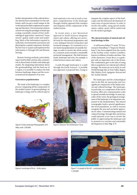
Figure 4: Sicily Landscape Physiographic Unit<br />
Map, scale 1:250.000.<br />
must represent a new way to reach a complete<br />
comprehension of the landscape<br />
through a holistic approach that considers<br />
and integrates all the components of the<br />
studied system.<br />
In recent years, a new theoretical<br />
approach to Earth Sciences integrates<br />
nature and culture, offering new powerful<br />
tools for educational programmes and<br />
a new dialogue between researchers and<br />
territorial managers. It is essential to try a<br />
new kind of popularization of scientific heritage,<br />
in order to involve the whole society<br />
in a common action towards a sustainable<br />
territorial management. The link between<br />
Earth, landscape and wine, for example, is<br />
a link between nature and culture.<br />
A path through landscapes is a path<br />
through the Earth Sciences. A possible<br />
new approach is proposed here, trying to<br />
Figure 5: Siracusa “Ear of Dionysius” Cave.<br />
integrate the complex aspects of the landscapes<br />
and the historical development of<br />
some areas of special interest, in order to<br />
involve the public, using special media:<br />
nature, culture, sports will be useful tools<br />
for the modern geologist.<br />
The characterization of natural and cultural<br />
heritage in film<br />
A well-known Italian TV serial, “Il Commissario<br />
Montalbano” (“Inspector Montalbano”);<br />
has been adapted from the novels<br />
of the Sicilian writer Andrea Camilleri,<br />
known to millions of readers and fans. One<br />
of the characters, Cesare Bocci, is a geologist<br />
with an important role in the fiction:<br />
this combination gave us the idea of using<br />
film to popularize our natural and cultural<br />
heritage. The stories are set in Sicily, in such<br />
World Heritage Sites as Noto Valley, Ragusa<br />
Ibla, Modica, Scicli, Agrigento, Siracusa and<br />
the Aeolian Islands.<br />
The landscapes and the archaeological<br />
sites in the film are spectacular and very<br />
significant components of the Italian natural<br />
and cultural heritage. The landscape,<br />
in particular, as a component of the movie<br />
location, offers new communication codes<br />
to spread scientific knowledge. In many episodes<br />
of the series, the geological arrangement<br />
of the landscape is an important component<br />
in the dramatization. The natural<br />
scenography lends a special significance:<br />
the local population, as well as tourists<br />
recognize the area and can better appreciate<br />
its value. Communicating natural and<br />
cultural heritage through film and fiction<br />
could represent a new way to involve the<br />
public in appreciating the landscape and<br />
to promote eco-tourism and sustainable<br />
development in Italy (Fig. 4-7).<br />
Figure 6: Landscape of Erice – Sicilia region.<br />
Figure 7: A sample of the GIS – Landscape physiographic Units of Erice -sc<br />
1: 250.000.<br />
<strong>European</strong> <strong>Geologist</strong> 34 | November 2012<br />
25