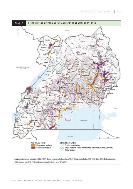
8 Wetland Characteristics and Uses Wetland Characteristics and Uses Wetlands cover about 15 percent (31,406 square kilometers) of Uganda’s total land area (205,212 square kilometers) and can be found in almost every subcounty. Most individual wetlands are linked to other wetlands through a complex network of permanent and seasonal streams, rivers, and lakes (Map 2), making them an essential part of the entire drainage system in Uganda (UN-WWAP and DWD, 2005). While such a dispersed geographic coverage provides wetland benefi ts to a greater number of people, it also increases the likelihood of overexploitation and degradation. Uganda’s high level of political and administrative decentralization adds to this risk. Most wetland systems cross administrative boundaries, which, because of compartmentalization of decision-making at the local level, makes it more diffi cult to manage wetlands in an integrative manner. With 11 sites designated as Wetlands of International Importance, Uganda is internationally recognized for leading the effort in Africa to conserve wetlands that are regionally and globally important for migratory bird species and biodiversity (Ramsar, 2006). Nonetheless, besides those wetlands that have international or national protection status, the great majority of wetlands lie outside the national protected area system (Map 2). Establishing a solid information base on wetland resources, their use, and condition is therefore essential to identifying successful wetland management approaches for the future. WETLAND CHARACTERISTICS To describe and categorize these resources, wetland managers often begin with three basic characteristics of wetlands: the permanence and seasonality of their moisture regime, the main vegetation and land cover types, and the resource pressure from human use. The following section categorizes Uganda’s wetlands by these key characteristics. About 75 percent of Uganda’s wetlands are seasonal, meaning they are not fl ooded for part of the year. In many locations, this dry period extends over most of the year. As Map 2 shows, seasonal wetlands can be found in almost every corner of Uganda. The great majority of these are narrow and elongated in shape, following valley bottoms and streams. These wetlands form densely branched networks, especially around Lake Kyoga. But they are also found in other areas such as Ssembabule, Lyantonde, and Kiruhura Districts. Large seasonal wetlands are located in various extensive fl oodplains, such as Katakwi, Nakapiripirit, and Moroto Districts (northeastern Uganda); at the southern end of Lake Albert; in Kasese District; and in Rakai District, bordering Tanzania. Permanent wetlands are mostly located near open water bodies such as lakes and rivers. The largest permanent wetlands are directly connected to Lake Kyoga and Lake Victoria. Others follow the banks of the Nile River from Lake Albert to the Sudanese border. Wetlands in Uganda are covered by a variety of vegetation types and occur in all of Uganda’s main land cover classes: tropical high forest, woodland, bushland, grassland, papyrus (including other sedges, reeds, and fl oating plants), and small and large-scale farmland. As Figure 1 indicates, the most common wetlands in Uganda are seasonally wet grasslands, covering 49 percent (about 15,326 square kilometers) of Uganda’s total wetland area. Seasonally wet woodlands are the second most common with 16 percent (5,136 square kilometers). Permanent wetlands consisting of papyrus and other sedges, reeds, and fl oating plants are the third most common wetland type and represent 15 percent (4,840 square kilometers) of Uganda’s wetland area. A signifi cant share of seasonal wetlands is used for crops, with 7 percent (2,322 square kilometers) of Uganda’s wetland area covered by small-scale farmland. The economic and subsistence uses of wetlands vary with land cover and whether they are seasonal or permanent. The type and level of use in turn determine how vulnerable each wetland is to becoming permanently degraded. Grasslands, for example, are primarily used for livestock grazing. If they have the right soils and water regime, they are also very desirable for growing crops. In the context of Uganda’s heavy dependence on agriculture (UBOS, 2007) and its growing demand for agricultural land, these wetlands are often prime targets for agricultural expansion. Woodland and papyrus wetlands, on the other hand, provide raw materials, the former for construction and fuel, and the latter for crafts and mats. Both woodland and papyrus wetlands are very vulnerable to over-harvesting of these products, especially if they are close to high demand centers or located along major transport routes. MAPPING A BETTER FUTURE
Wetland Characteristics and Uses 9 Map MAP 2 DISTRIBUTION OF PERMANENT AND SEASONAL WETLANDS, 1996 Sources: International boundaries (NIMA, 1997), district administrative boundaries (UBOS, 2006a), water bodies (NFA, 1996; NIMA, 1997; Brakenridge et al., 2006), wetness type (NFA, 1996), and major national protected areas (NFA, 2007). How Spatial Analysis Can Benefit Wetlands and Reduce Poverty in Uganda