ENVIRONMENTAL STATEMENT BARDOLINO DEVELOPMENT
ENVIRONMENTAL STATEMENT BARDOLINO DEVELOPMENT
ENVIRONMENTAL STATEMENT BARDOLINO DEVELOPMENT

Create successful ePaper yourself
Turn your PDF publications into a flip-book with our unique Google optimized e-Paper software.
Bardolino Development Environmental Statement<br />
4 <strong>ENVIRONMENTAL</strong> DESCRIPTION<br />
4.1 INTRODUCTION<br />
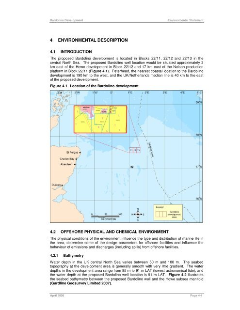
The proposed Bardolino development is located in Blocks 22/11, 22/12 and 22/13 in the<br />
central North Sea. The proposed Bardolino well location would be situated approximately 3<br />
km east of the Howe development in Block 22/12 and 17 km east of the Nelson production<br />
platform in Block 22/11 (Figure 4.1). Peterhead, the nearest coastal location to the Bardolino<br />
development is 190 km to the west, and the UK/Netherlands median line is 40 km to the east<br />
of the proposed development.<br />
Figure 4.1 Location of the Bardolino development<br />
4.2 OFFSHORE PHYSICAL AND CHEMICAL ENVIRONMENT<br />
The physical conditions of the environment influence the type and distribution of marine life in<br />
the area, determine some of the design parameters for offshore facilities and influence the<br />
behaviour of emissions and discharges (including spills) from offshore facilities.<br />
4.2.1 Bathymetry<br />
Water depth in the UK central North Sea varies between 50 m and 100 m. The seabed<br />
topography at the development area is generally smooth with very little gradient. The water<br />
depths in the development area range from 85 m to 91 m LAT (lowest astronomical tide), and<br />
the water depth at the proposed Bardolino well location is 91 m LAT. Figure 4.2 illustrates<br />
the seabed bathymetry between the proposed Bardolino well and the Howe subsea manifold<br />
(Gardline Geosurvey Limited 2007).<br />
April 2008 Page 4-1
![Download Shell AutoGas Stationen [Stand: Januar 2013] (PDF](https://img.yumpu.com/9982753/1/190x245/download-shell-autogas-stationen-stand-januar-2013-pdf.jpg?quality=85)