ENVIRONMENTAL STATEMENT BARDOLINO DEVELOPMENT
ENVIRONMENTAL STATEMENT BARDOLINO DEVELOPMENT
ENVIRONMENTAL STATEMENT BARDOLINO DEVELOPMENT

You also want an ePaper? Increase the reach of your titles
YUMPU automatically turns print PDFs into web optimized ePapers that Google loves.
Bardolino Development Environmental Statement<br />
Source: Anatec UK Ltd. (2006)<br />
Routes 1, 5 and 6 are located close to the Bardolino well site, tie-back pipelines and Howe<br />
subsea manifold. Details of these routes are as follows:<br />
• Route No. 1 is used by an estimated 20 vessels per year between Aberdeen (GBR)<br />
and Egersund. Cargo vessels, approximately 1,500 to 5,000 dwt in weight account<br />
for all vessels travelling this route. This route passes to the north of the proposed<br />
locations for the Bardolino well and associated tie-back pipelines.<br />
• Route No. 5 is used by an estimated 30 vessels per year between Iceland and<br />
Hamburg. The majority of vessels travelling this route are cargo vessels ranging from<br />
1,500 to 5,000 dwt to 15,000 to 40,000 dwt in weight. This route passes to the<br />
northeast of the proposed locations for the Bardolino well and associated tie-back<br />
pipelines.<br />
• Route No. 6 is used by an estimated 100 vessels per year between Tees and<br />
Sognefjorden. Tanker vessels, ranging from 1,500 to 5,000 dwt, 5,000 to 15,000 dwt<br />
and 15,000 to 40,000 dwt in weight, travel this route. This route passes to the<br />
southeast of the proposed locations for the Bardolino well and associated tie-back<br />
pipelines.<br />
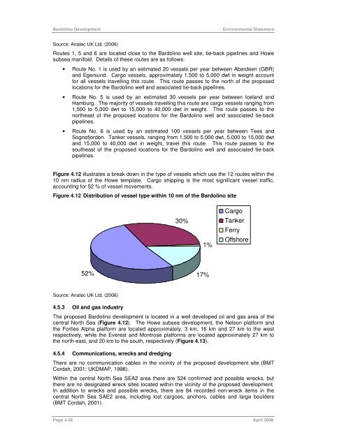
Figure 4.12 illustrates a break down in the type of vessels which use the 12 routes within the<br />
10 nm radius of the Howe template. Cargo shipping is the most significant vessel traffic,<br />
accounting for 52 % of vessel movements.<br />
Figure 4.12 Distribution of vessel type within 10 nm of the Bardolino site<br />
52%<br />
Source: Anatec UK Ltd. (2006)<br />
4.5.3 Oil and gas industry<br />
30%<br />
Page 4-36 April 2008<br />
1%<br />
17%<br />
Cargo<br />
Tanker<br />
Ferry<br />
Offshore<br />
The proposed Bardolino development is located in a well developed oil and gas area of the<br />
central North Sea (Figure 4.12). The Howe subsea development, the Nelson platform and<br />
the Forties Alpha platform are located approximately, 3 km, 16 km and 27 km to the west<br />
respectively, while the Everest and Montrose platforms are located approximately 27 km to<br />
the north-east, and 20 km to the south, respectively (Figure 4.13).<br />
4.5.4 Communications, wrecks and dredging<br />
There are no communication cables in the vicinity of the proposed development site (BMT<br />
Cordah, 2001; UKDMAP, 1998).<br />
Within the central North Sea SEA2 area there are 524 confirmed and possible wrecks, but<br />
there are no designated wreck sites located within the vicinity of the proposed development.<br />
In addition to wrecks and possible wrecks, there are 84 recorded non-wreck items in the<br />
central North Sea SAE2 area, including lost cargoes, anchors, cables and large boulders<br />
(BMT Cordah, 2001).

![Download Shell AutoGas Stationen [Stand: Januar 2013] (PDF](https://img.yumpu.com/9982753/1/190x245/download-shell-autogas-stationen-stand-januar-2013-pdf.jpg?quality=85)