guideline and standards for skytem measurements, processing and ...
guideline and standards for skytem measurements, processing and ...
guideline and standards for skytem measurements, processing and ...

Create successful ePaper yourself
Turn your PDF publications into a flip-book with our unique Google optimized e-Paper software.
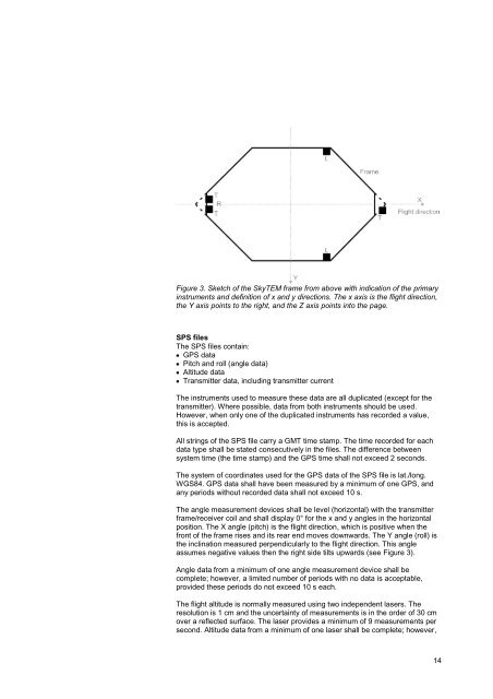
Figure 3. Sketch of the SkyTEM frame from above with indication of the primary<br />
instruments <strong>and</strong> definition of x <strong>and</strong> y directions. The x axis is the flight direction,<br />
the Y axis points to the right, <strong>and</strong> the Z axis points into the page.<br />
SPS files<br />
The SPS files contain:<br />
GPS data<br />
Pitch <strong>and</strong> roll (angle data)<br />
Altitude data<br />
Transmitter data, including transmitter current<br />
The instruments used to measure these data are all duplicated (except <strong>for</strong> the<br />
transmitter). Where possible, data from both instruments should be used.<br />
However, when only one of the duplicated instruments has recorded a value,<br />
this is accepted.<br />
All strings of the SPS file carry a GMT time stamp. The time recorded <strong>for</strong> each<br />
data type shall be stated consecutively in the files. The difference between<br />
system time (the time stamp) <strong>and</strong> the GPS time shall not exceed 2 seconds.<br />
The system of coordinates used <strong>for</strong> the GPS data of the SPS file is lat./long.<br />
WGS84. GPS data shall have been measured by a minimum of one GPS, <strong>and</strong><br />
any periods without recorded data shall not exceed 10 s.<br />
The angle measurement devices shall be level (horizontal) with the transmitter<br />
frame/receiver coil <strong>and</strong> shall display 0° <strong>for</strong> the x <strong>and</strong> y angles in the horizontal<br />
position. The X angle (pitch) is the flight direction, which is positive when the<br />
front of the frame rises <strong>and</strong> its rear end moves downwards. The Y angle (roll) is<br />
the inclination measured perpendicularly to the flight direction. This angle<br />
assumes negative values then the right side tilts upwards (see Figure 3).<br />
Angle data from a minimum of one angle measurement device shall be<br />
complete; however, a limited number of periods with no data is acceptable,<br />
provided these periods do not exceed 10 s each.<br />
The flight altitude is normally measured using two independent lasers. The<br />
resolution is 1 cm <strong>and</strong> the uncertainty of <strong>measurements</strong> is in the order of 30 cm<br />
over a reflected surface. The laser provides a minimum of 9 <strong>measurements</strong> per<br />
second. Altitude data from a minimum of one laser shall be complete; however,<br />
14